FAQ: How the Woolsey Fire Will Affect the Bay
November wildfires in California exacted a terrible toll, from the horrific devastation of the Camp Fire up north to the destruction wreaked by blazes in the greater Malibu area. Here we provide a detailed FAQ about how the Woolsey Fire affected the Santa Monica Mountains area, what the future holds for our region’s largest natural space, and what it all means for the Bay.
How bad is the damage in the Woolsey Fire burn areas from an ecological point of view?
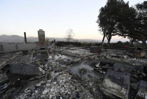
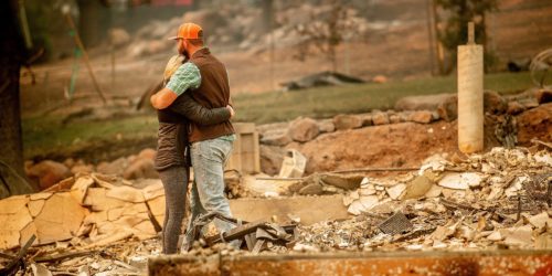
The Woolsey fire burned nearly 97,000 acres and the nearby Hill Fire in Ventura County scorched approximately 4,500 acres. Three lives and many structures were sadly lost. Habitat and open space also suffered big losses; 88% of the land in the Santa Monica Mountains National Recreation Area (SMMNRA) owned by the National Park Service burned. This total does not include land owned by partner agencies — such as State Parks, which is also considered part of the SMMNRA; however, many of those areas also burned.
Chaparral in Southern California’s coastal zones is adapted to fire, but the frequency at which wildfires are occurring is not natural. Humans cause an estimated 95% of California’s blazes. Fires can be harmful to plants, animals, and the ecosystem.
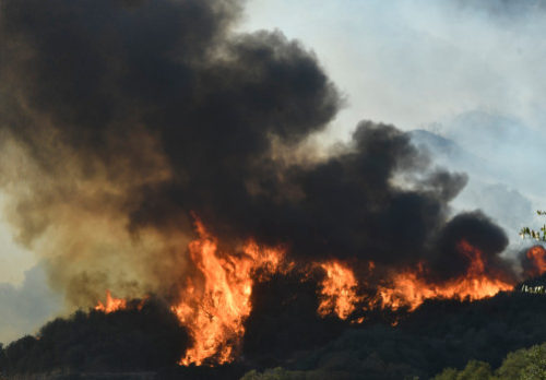
Thick black smoke and heavy flames from the Woolsey fire burn out of control in the mountains in Malibu on Sunday, November 11. (Photo by Gene Blevins)
Plant species and communities adapt to typical fire patterns over time; if that cycle changes in frequency or intensity, we may expect to see longer recovery times. Habitats often cannot recover on their own. For instance, if its seed bank is destroyed by a very intense inferno, the native plant community may not be able to regenerate. After fires, invasive species may proliferate. One plant community may convert to another less biodiverse or complex zone.
Blazes also have big impacts on streams; they change the physical state of the waterway through increased inputs of sediment. For instance, after a fire, and particularly after a rain, deep pools in streams will be filled in with sediment. These changes can last for many years until the sediment is pushed out, which only occurs after many large storms.
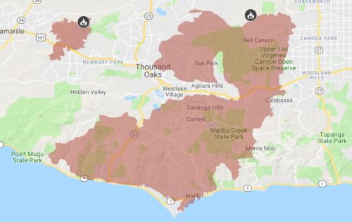
Map of burned area from http://www.fire.ca.gov/
What about recreation? What are near-term impacts for visitors to area State Parks and State Beaches?
Many recreational areas are closed. Be sure to check for the latest updates before you head to them.
SMMNRA: Many structures burned: most of Western Town in Paramount Ranch; Peter Strauss Ranch; part of the NPS/UCLA LA Kretz Field Station; luckily, the Anthony C. Beilenson Interagency Visitor Center at King Gillette Ranch was spared but remains closed. The NPS recommends hiking at Rancho Sierra Vista/Satwiwa and at Cheeseboro and Palo Comado Canyons until other areas are opened.
State Parks & Beaches: Malibu Creek and Leo Carrillo State Parks sit in the burn area. They lost structures and remain closed. Structures lost at Malibu Creek State Park include: employee residences, the historic Sepulveda Adobe, the Red House, the M.A.S.H. set, Hope Ranch (also known as the White Oak Barn) and the Reagan Ranch. Structures lost at Leo Carrillo State Park include: the visitor center, sector office, employee residences, three lifeguard towers, Leo Shop structures, the Junior Lifeguard Complex, and several restrooms. Point Mugu and Topanga State Parks were not in the immediate fire zone but remain closed. The Woolsey fire burned El Matador Beach, and part of the Robert H. Meyer Memorial State Beach, which remains closed. La Piedra and El Pescador are closed but did not burn. Malibu Lagoon and Point Dume State Beaches also remained out of the fire’s path but are closed.
Check on the status of State Parks and Beaches here: https://www.parks.ca.gov
Check on road closures here: https://dpw.lacounty.gov/roadclosures/
What happened to all the animals that lived there?
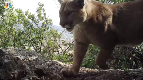
Many larger more mobile animals likely escaped immediate danger, such as deer, coyotes, bobcats, and mountain lions. In fact, the beloved mountain lions of the Santa Monica Mountains fared pretty well; of the 13 tracked via radio-collars by SMMNRA wildlife biologists, 12 have been confirmed as alive and moving. Unfortunately, #P74 is now presumed dead. Much of the cats’ needed habitat is gone, their food sources are reduced, and the remaining habitat will likely be unable to accommodate the large home ranges that they all require. Smaller less mobile animals likely suffered more direct losses than larger animals. However, all animals face the ongoing long-term impacts of habitat and food loss and increased competition.
Animals that live in streams face additional challenges, particularly as sediment and toxins enter the water after rains. The endangered red-legged frog requires deep pools with year-round water; the NPS has been successfully reintroducing red-legged frogs to a few locations throughout the Santa Monica Mountains. However, a rainfall in a burned area can bring significant amounts of sediment into these pools, filling them in completely and obliterating the frog’s habitat. Luckily, the source population for the red-legged frogs survived the Woolsey fire but ongoing vigilance will be required to ensure their survival.
How long will it take for the area to recover?
A biologist from the SMMNRA told the LA Times that it will take 10-20 years for the area to recover ecologically. Restoration activities, such as planting native plants and trees and removal of invasive species, will likely be needed in many areas. It will likely take significant time for the animal populations to reestablish themselves. Ongoing and new research will be key to monitoring the health of the ecosystems and success in recovery.
How will water quality be affected? What are the biggest dangers?
Fires can have significant detrimental effects on water quality. A forest or brush fire can exacerbate natural processes, such as the leaching of organic material and nutrients from soil, by removing stabilizing vegetation and increasing the potential for sediment runoff into waterways. Additionally, the concentrated brominated flame retardants used to contain and extinguish these fires are toxic and persistent, with long-term effects on water quality, aquatic life, and plant life.
While many of the immediate environmental impacts of a fire are local, atmospheric contamination from the fire plume can travel very long distances and redeposit toxic particulate matter on land or in waterways in other parts of the state and even in other parts of the U.S. Recent fires in California have caused unprecedented loss of private property, which means that the particulate matter in the fire plumes include the chemicals that are used or stored in our homes, offices and automobiles. This includes the metals and chemicals used to construct a building, the fuel from cars, cleaning supplies, other chemicals stored in garages, and much more.
What are the potential effects on water quality when rains – and possibly flooding and mudslides – come?
Stormwater is well known to be a major source of pollution in our waterways, particularly during a “first flush” event. After a storm, pollutants that have settled on the ground are washed into our rivers, lakes and ocean. After a fire, pollution on the ground is increased by the deposition of toxic particulate matter from the fire plume. Rain washes brominated flame retardants and the rest of this contamination into our waterways.
Fires can also cause more runoff, which means less natural filtration to remove contaminants from the environment. Blazes can destabilize the ground beneath us in some areas by removing vegetation, but it can also harden natural surfaces in other areas. This can occur simply through drying out healthy soil into a hardpan. Some plants, when burned, can leave behind a waxy residue creating a water repellent barrier (from KPCC). This combination of enhanced natural processes, the presence of new toxic chemicals and increased erosion and runoff can cause toxic water conditions, detrimental to environmental, aquatic and public health.
Why are the Santa Monica Mountains important to our local environment?
The Santa Monica Mountains provide critical habitat and open space in close proximity to urban Los Angeles. Los Angeles is located in a biodiversity hotspot; this means that we have more species of plants and animals here compared to many other areas of the country and world. Many plants and animals thrive here and nowhere else, and unfortunately, development and other human impacts threatens this bio-diversity. The Santa Monica Mountains National Recreation Area is the world’s largest urban national park and the area provides an incredible opportunity for Angelenos to experience and connect with the natural world.
How is the health of the coastal mountains related to the health of the Bay?
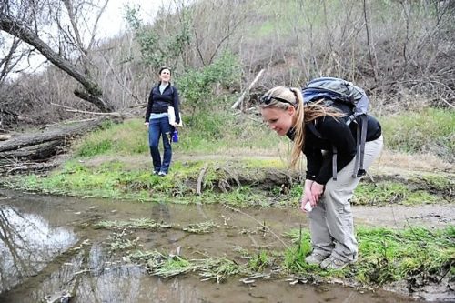
Healthy watersheds and healthy coastal waters are inextricably linked. Heal the Bay has long worked in the Santa Monica Mountains. (You can see some of our scientists at work in the photo below.) In 1998, we started our Stream Team community science program to assess the health of the Malibu Creek Watershed (the largest watershed in the Santa Monica Mountains and second largest draining to Santa Monica Bay). For 15 years, we conducted monthly water quality monitoring at 12 sites throughout the mountains. We also removed stream barriers and invasive species. In 2013, we published a comprehensive report on the State of the Malibu Creek Watershed. Every summer, we continue to monitor the water quality at popular freshwater swimming holes in Malibu Creek State Park. The land use, management, and way we treat the Santa Monica Mountains and all watersheds directly impacts the health of our local waters for humans and wildlife.
How can we all help people that live in fire-ravaged areas?
STAY INFORMED by following the official sources for disaster relief and recovery resources, including how to donate, upcoming volunteering opportunities, urgent safety information and more:
- Butte County Recovery: https://buttecountyrecovers.org/
- Los Angeles County Recovery: http://www.lacounty.gov/woolseyfire/
- Ventura County Recovery: http://venturacountyrecovers.org/
HOST PEOPLE IN NEED of emergency housing through Airbnb. Many people have been displaced and a roof over their heads along with a warm meal can help with health and wellness, as well as provide the temporary security and comfort people need to get back on their feet.
CONTINUE HELPING days, weeks and months after the disaster occurs. Give blood. Sign up to be a disaster relief volunteer or an environmental educator. Host a fundraiser. Whatever it is you can do, keep it up!
How can people help with the restoration of these natural places?
It is too early to start restoration work right now. Once needs have been better assessed, check out these great organizations and resources for ways to get involved:
SAMO Fund This nonprofit supports the preservation and enjoyment of the SMMNRA; their Outdoors calendar lists great opportunities by many organizations.
SMMNRA Our local National Recreation Area also offers direct volunteer opportunities.
Mountains Restoration Trust MRT has long been a partner with Heal the Bay. MRT suffered the loss of its plant nursery in the fire but we know the group will continue to do great work of habitat restoration and removal of invasive crayfish from local streams.
TreePeople The organization works to restore areas of the Santa Monica Mountains by planting native plants and trees, caring for them, and removing invasive species.
Will this happen again?
Unfortunately, catastrophic fire events are likely to happen again in California. Gov. Jerry Brown aptly noted “This is the new abnormal, and this new abnormal will continue.” Experts from all fields, including CAL FIRE Director Ken Pimlott, agree that climate change is creating conditions in many parts of the world that make fires in California more likely and more severe. The Fourth National Climate Assessment estimates that the amount of acres burned by fires each year will almost double by 2060.
What is the direct connection to climate change, if any?
It would be inaccurate to say that climate change is the cause of these wildfires in California. However, the impacts of climate change have produced the ideal conditions for record breaking fires. Globally, we have seen 16 of the last 17 years documented as the hottest years on record. With climate change, we anticipate longer periods of drought, followed by heavy precipitation events in California — a weather whiplash, so to speak. We recently experienced the worst drought in California’s history, followed by a very wet winter in 2016-17. While it gave us an incredible super bloom that we could see from outer space, it also ended up leaving behind a lot of dead fuel as the record-breaking temperatures and drought conditions resumed. As a result, we have witnessed 4 of the top 20 largest fires in California in the last two years. And 15 of the 20 these blazes have occurred since 2002. The Camp Fire, however, is the most destructive by a long shot. And unfortunately, when floods follow fire, dangerous mudslides can result.
How can we better prepare to reduce the risk of this happening again?
In the long term, the best way to reduce the risk of fires is to address the effects of climate change by reducing our greenhouse gas emissions and returning our environment to a more natural system (with healthy soils, healthy vegetation and a healthy aquatic ecosystem) that can sequester carbon. This will ensure that the conditions we are experiencing today do not get worse. And there any many small changes that everyone can make at home to help reach this goal, like using public or active transportation, making sure that your home is energy-efficient, and planting new vegetation.
However, we know all too well this these fires are not a future issue, but a risk that we face today. So what can we do today to protect ourselves, our loved ones and our property? The California Wildland Fire Coordinating Group has some tips, at PreventWildfireCA.org, including campfire safety, debris burning, and equipment use. And Cal FIRE has released a guide called Prepare for Wildfire, with instructions on how to put in fire-safe landscaping and create an evacuation plan.