Changes are Coming to the L.A. River
Sign up for our “Knowledge Drops – Wait, what’s happening to the L.A. River?” webinar on December 3
When I first visited Los Angeles in 2015, I was not interested in seeing the Hollywood Walk of Fame or the Hollywood Sign. Instead, I asked my local friends to take me directly to the L.A. River. I wanted to see the hallmark concrete embankments where so many movie car chases happened and the thin ribbon of water I watched my favorite skateboarders jump over (with mixed success).
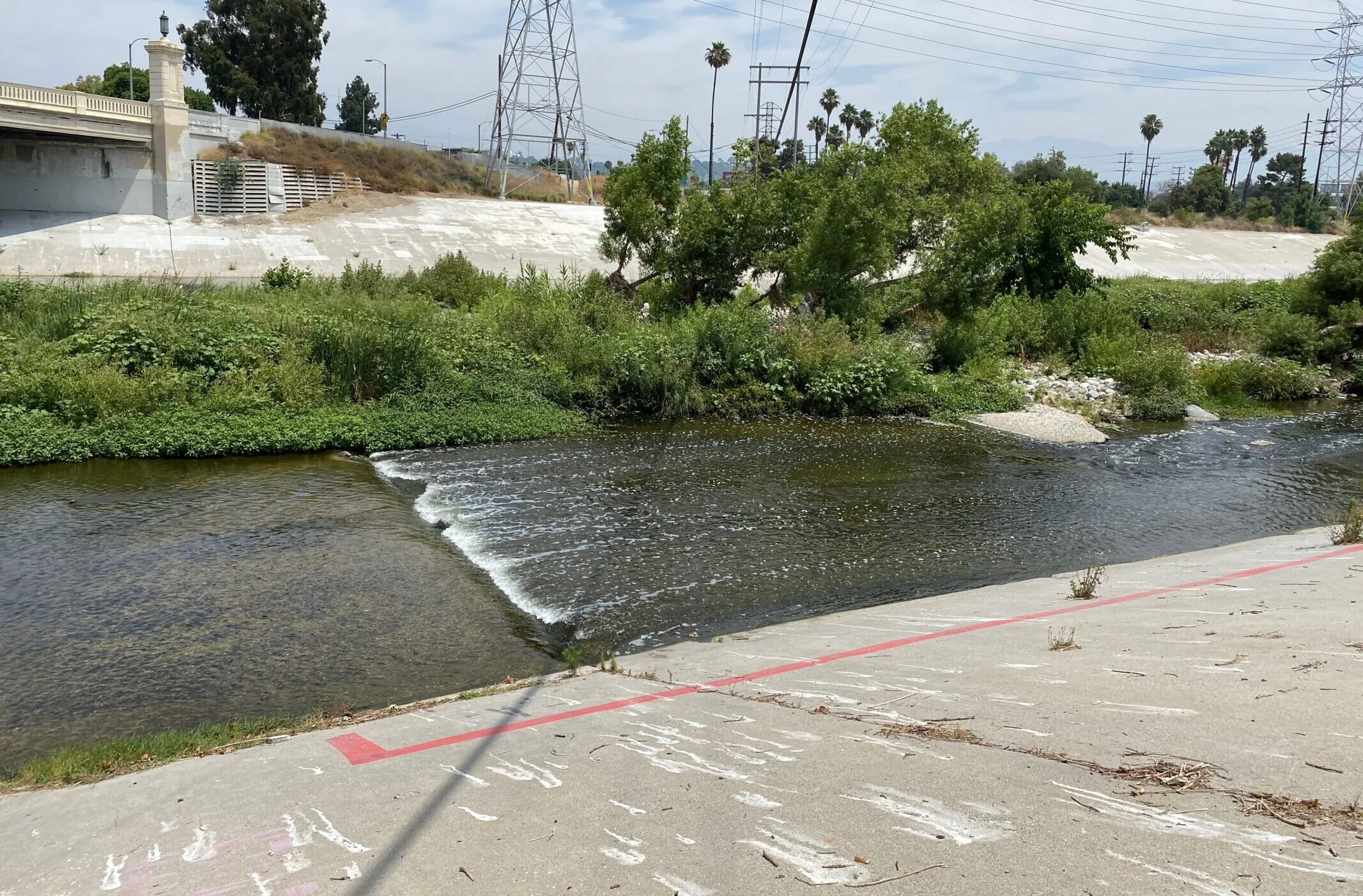
The L.A. River has A-List status far outside of the Los Angeles area, and is recognized by people all over the globe. Its notoriety is mostly due to its unique appearance. It doesn’t look like a typical river at all, instead it looks like – and functions as – a storm drain channel.
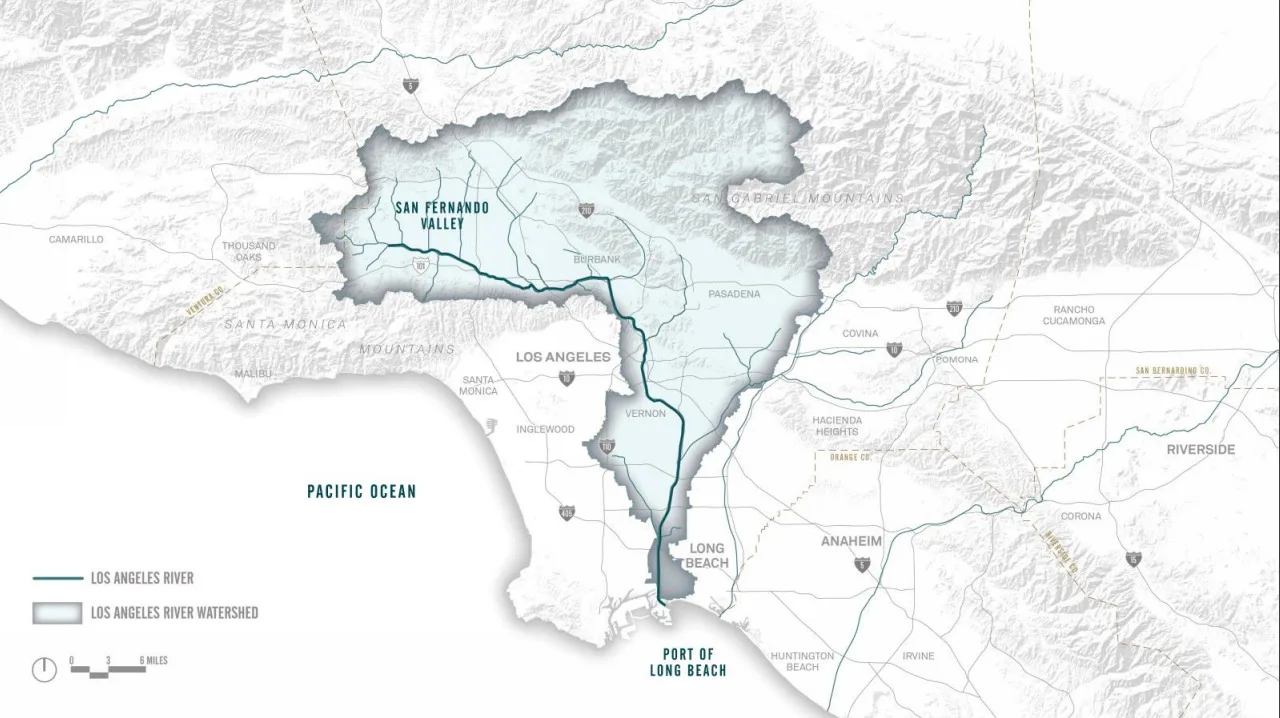
The L.A. River begins in Canoga Park where Bell Creek and Arroyo Calabasas converge, and it runs 51 miles through the City of Los Angeles and over 17 other cities, draining over 800 square miles of land, before it flows into the Pacific Ocean in Long Beach.
The History of the L.A. River
In pre-colonial Los Angeles County, water from rivers and streams naturally flowed and supported Tongva, Tataviam, and Chumash Peoples in the area. Later, the L.A. River and its tributaries supported the colonial settlements that were violently and coercively established on local Indigenous territories.

1800’s Before Colonial Settlement. Source: Seaver Central For Western History Research / Natural History Museum Los Angeles County, riverlareports.riverla.org
A population boom in the early 1900’s meant the L.A. River and its tributaries could no longer support the water demand for the area. Cities began sourcing water from the Colorado River and Northern California, and the L.A. River gradually went from being a vital local water source to being seen as a nuisance.
From 1900-1940 there were multiple floods of the L.A. River that destroyed neighborhoods and resulted in fatalities. The colonial cities along the river failed to respect the L.A. River as the Indigenous People had, and instead built homes and buildings within the River’s floodplain.

1938 Colfax Avenue Bridge Studio City. Source: Regional History Center / USC, riverlareports.riverla.org
In response to the floods, the U.S. Army Corps of Engineers decided to pour concrete over the sides and bottom of the L.A. River channel and its tributaries to create a network of concrete storm drain channels. The concretization of the river led to a reduction in flood risk because it forced water to flow much more quickly down the river and out to the ocean. But, the concrete completely decimated the river ecosystem and the services it once provided, including cultural value, habitat for wildlife, and greenspace for recreation.
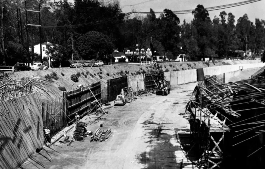
1949 Laurel Canyon Channel Construction. Source: riverlareports.riverla.org
After the river was concretized, Indigenous People, activists, and environmental organizations demanded the restoration of the L.A. River and its tributaries back into a functioning natural river ecosystem.
Now with the climate crisis, we can no longer afford to have a concretized river system that solely provides flood control. We need a river system that will help cool communities as temperatures rise, provide habitat for diverse wildlife, increase local water resiliency, and serve as a greenspace where communities can recreate and reconnect with nature and culture.
Government agencies have identified the need to re-establish all of the lost ecosystem services as well, and have implemented six major plans with the goal of transforming the L.A. River and its tributaries into a multi-benefit system that will serve the surrounding communities.
Here we summarize these plans and let you know how to get involved.
Los Angeles River Master Plan Update (LARMPU)
The LARMPU is a plan created by L.A. County with the goal of transforming the L.A. River. The original Master Plan was drafted in 1996, and its main goal was to beautify the river while maintaining its functionality as a stormwater conveyance system. The 2020 update of the Master Plan was set into motion to ensure the L.A. River has spaces that provide more benefits in addition to flood abatement and beautification. As stated in the plan, projects will reduce flood risk; improve parks and open space; improve river access; support the ecosystem; provide cultural and educational opportunities; address housing affordability and homelessness; improve local water resilience; and promote water quality.
Heal the Bay was selected to serve as a Steering Committee member for the update and has been attending meetings and offering feedback over the last two years. The updated Master Plan for the entire River is expected to be released to the public in the next few weeks as a draft open for public comments – stay tuned for updates on that and be ready to share your thoughts on the River and the Master Plan.
Meanwhile, the Master Plan has to go through the CEQA (California Environmental Quality Act) process and a programmatic Environmental Impact Report (EIR) is being prepared for the Master Plan itself (see this fact sheet for more explanation).
Upper L.A. River Master Plan (ULART Plan)
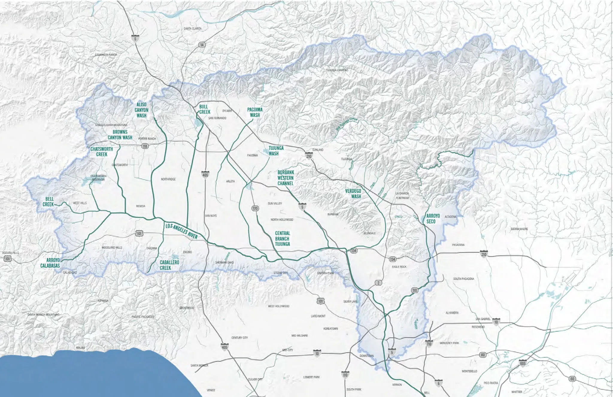
The ULART Working Group (formed by Assembly Bill 466 & Senate Bill 1126) developed this plan so low income communities with limited access to greenspace in the L.A. River Watershed have the opportunity to implement projects such as parks and paths along the river. The ULART Plan was developed to revitalize the L.A. River from Canoga Park to Vernon as well as Aliso Canyon Wash, Pacoima Wash, Tujunga Wash, Burbank Western Channel, Verdugo Wash, and the Arroyo Seco. This plan has identified areas along the L.A. River and its tributaries where multi-benefit projects will be implemented. This is the only plan discussed here that addresses tributaries, which have largely been ignored by revitalization efforts in the past.
As stated by the ULART Plan, the goals are to enhance the ecosystem; maintain and enhance flood management; increase opportunities for culture, arts, and recreation; and increase connectivity and green space along the river system. This plan has identified areas along the L.A. River and its tributaries where projects such as parks and bike paths can be designed and implemented. And, community members are encouraged to collaboratively develop project ideas and get them constructed. The plan was finalized and adopted in April 2020 and can be found on the ULART website.
Lower L.A. River Revitalization Plan
The Lower L.A. River Revitalization Plan was set forth in Assembly Bill 530, and unlike the other plans discussed, has been in the implementation phase since 2018. This plan covers revitalization efforts in the lower 19 miles of the L.A. River from Vernon to Long Beach. Communities in this section of the river have lower than average incomes in L.A. County, are predominantly People of Color, and have been historically underserved by economic, educational, and environmental services. Local residents are disproportionately exposed to pollution and have little access to green space among other environmental injustices. Therefore, it is crucial the Lower L.A. River Revitalization Plan works to create benefits that will address systemic issues. As stated by the plan, the goals are:
- Create diverse, vibrant public spaces along and connected to the Lower Los Angeles River resulting in safe, inviting, healthy green spaces that support diverse local communities, allowing equitable access to nature and a variety of recreation entertainment, multi-modal transportation and socio-economic opportunities that enhances quality of life and sustains watershed health.
- Conserve and restore natural river and watershed functions while managing flood risk, enhancing the long-term ecosystem services provided to surrounding communities and mitigating climate changes and environmental impacts of urbanizing on the Lower L.A. River, floodplains, and associated habitats.
Heal the Bay was on the Working Group to help develop and offer feedback on the Plan and currently attends the Implementation Advisory Group meetings, where specific projects are brought forward for discussion and feedback in context of the Master Plan.
Los Angeles River Revitalization Master Plan (LARRMP)
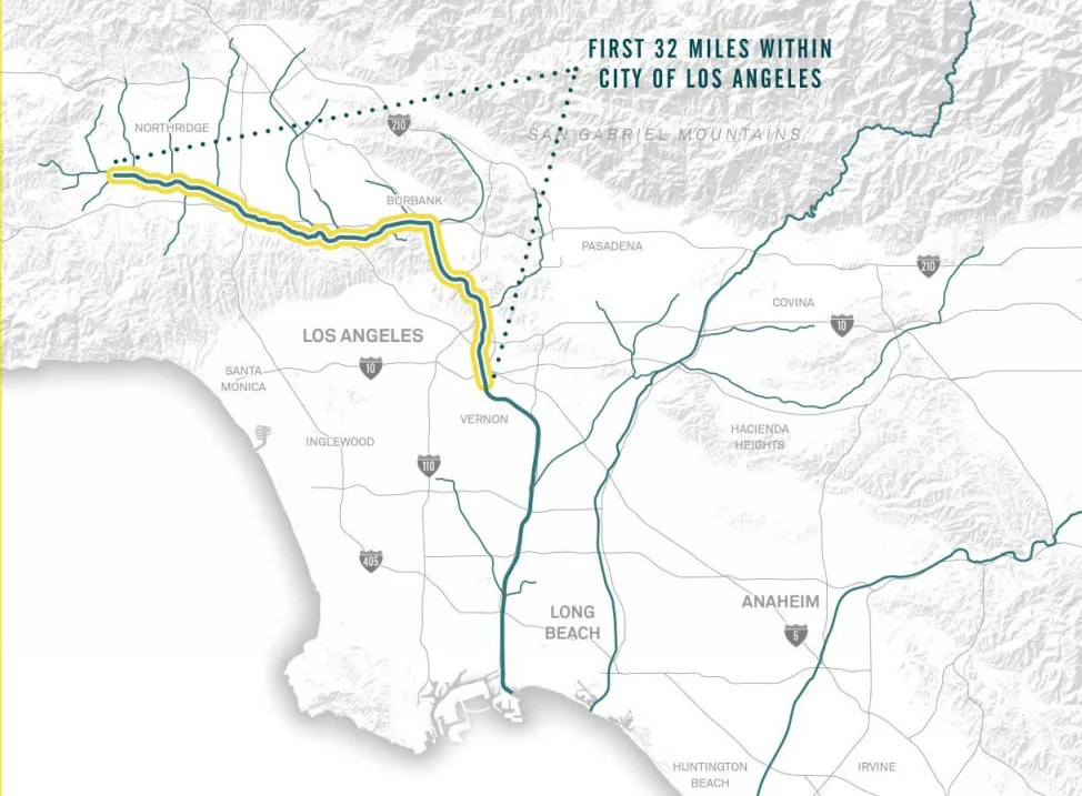
This LARRMP was approved by the Los Angeles City Council in 2005, and it aims to revitalize the 32 miles of the L.A. River within L.A. City limits. The plan is intended to serve as a blueprint for transforming the river over the next 25-50 years, and the four “core principles” of the plan are as follows:
- Revitalize the river by creating a continuous stretch of riparian habitat throughout the 32 mile section of the river in the city boundaries. The plan states that concrete removal will be considered as long as flood abatement ability of the river channel is not compromised.
- Creating a continuous “River Greenway” that would consist of a network of bikeways, pedestrian paths, “green connections,” and open space.
- Create a river that is safe, accessible, healthy, sustainable, and celebrated. The LARRMP states that it will address environmental justice issues by redeveloping polluted areas and providing natural spaces in neighborhoods that lack them.
- Create value by encouraging participation and consensus-building, creating opportunities for sustainable, economic reinvestment, and adding value and providing an equitable distribution of opportunities to underserved neighborhoods along the River.
Projects under this plan are still ongoing, but some projects like Albion Riverside Park, have already been completed. Check the LARRMP website for updates.
Los Angeles River Ecosystem Restoration Feasibility Study
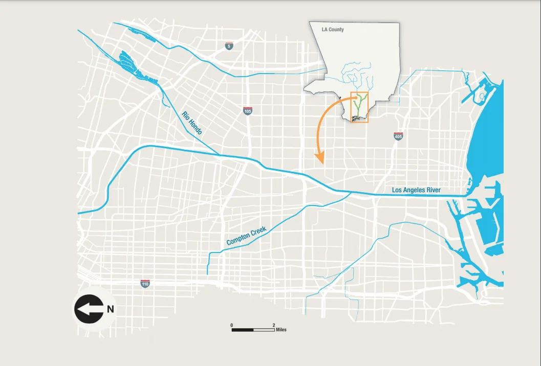
Adopted by the Los Angeles City Council in 2016, this proposed plan would transform 11 miles of the Elysian Valley in the Los Angeles River. The restoration would include the creation of riparian and marsh habitat, enhancing habitat connectivity to other natural areas such as the Santa Monica and San Gabriel Mountains. The plan will also include a natural hydrologic regime with the goal of restoring historic floodplains and connections to Los Angeles River tributaries. Ecological restoration under this plan will also allow for certain passive recreation opportunities like nature walks. There are some preliminary projects that must be completed before this plan is implemented, but the project is expected to be completed by 2029.
Los Angeles River Flows Project
Historically, the water in the L.A. River came from rainfall and groundwater upwelling in the Glendale Narrows. While that remains the case today, wastewater is now the dominant source of water in the main channel of the river during dry weather. The Tillman Water Reclamation Plant in Van Nuys and the Los Angeles-Glendale Water Reclamation Plant near Griffith Park both discharge treated wastewater into the L.A. River on a daily basis. Although this water originated from toilets, sinks, and drains, it is relatively free of contaminants like fecal matter.
In light of the recent long-term drought conditions in California and the looming threat of climate change, wastewater managers in L.A. are rethinking the practice of discharging treated wastewater into the L.A. River. That wastewater can be recycled, which would result in improved water resilience in times of drought and sustainable local water. However, the reduction of wastewater discharges into the river poses a potential problem for the river ecosystem that has come to rely on that water source. The State Water Board and other stakeholders have created the Los Angeles River Flows Project to evaluate the environmental and recreational impacts of reducing wastewater discharge into the L.A. River. The goal is to identify a water flow regime that will support a healthy river ecosystem, allow for recreation opportunities, and recycle enough water to be drought resilient.
Right now, the L.A. River Flows Project has been conducting analyses to identify the optimal flow regime, and research and meetings are planned to continue through the end of 2020. After that, a plan will be drafted and there will ideally be an opportunity for the public to weigh in on the plan.
Heal the Bay is a member of the Technical Advisory Committee as well as part of the Stakeholder Working Group. We will keep you updated on the progress of this and if there are opportunities for the public to voice their comments.
What’s with all these plans for the L.A. River?
Revitalizing the L.A. River is a monumental task so it makes sense to break the revitalization effort into different pieces. However, the main reason for this patchwork of plans is that they are all being led by different agencies. The LARMPU was created by L.A. County and ULART and the Lower L.A. River Revitalization Plan were created by legislation at the state level. The L.A. River Flow Plan was mandated by the State Water Resource Control Board. The LARRMP and L.A. River Ecosystem Restoration Feasibility Study are both overseen by the City of Los Angeles. Each plan states that it will work in conjunction with all the other plans; however, it is unclear what that collaboration will look like as three of the plans are not in the implementation phase yet.
What will these plans do exactly?
The L.A. River Master Plan, ULART, LARRMP, and Lower L.A. River Revitalization Plan will all identify areas along the L.A. River watershed where there is space for a project. A project can take the shape of many different things such as a park, retail space, housing, bike path, nature trail, and habitat among other things. The spaces where these projects will be placed are government owned or easily obtainable by a government agency. The Flows Project will not consist of any projects, instead, it will make recommendations on the amount of water in the river. This might change the habitat characteristics of the river as well as the recreational opportunities. We will know more as the plan continues to take shape. The L.A. River Revitalization Master Plan has already identified the locations of proposed projects.
How can I get involved?
When the L.A. River Master Plan is released to the public, you can provide comments about the changes you would like to see in the watershed. The Flows Plan has not been released yet, but the public will have the opportunity to comment when it is released. As plans are implemented, you will have the opportunity to weigh in on each individual project that gets implemented. We recommend tracking these projects on the L.A. River Master Plan, Lower L.A. River Master Plan, ULART Plan, LARRMP, and L.A. River Ecosystem Restoration Feasibility Study websites.
Los Angeles River Access and Points of Interest
Click on a trail segment, access point, or icon for photos and to learn more.