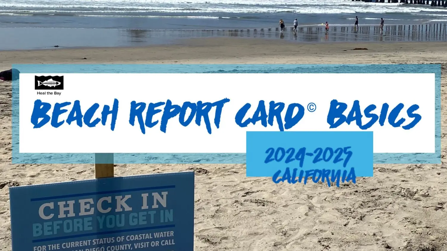
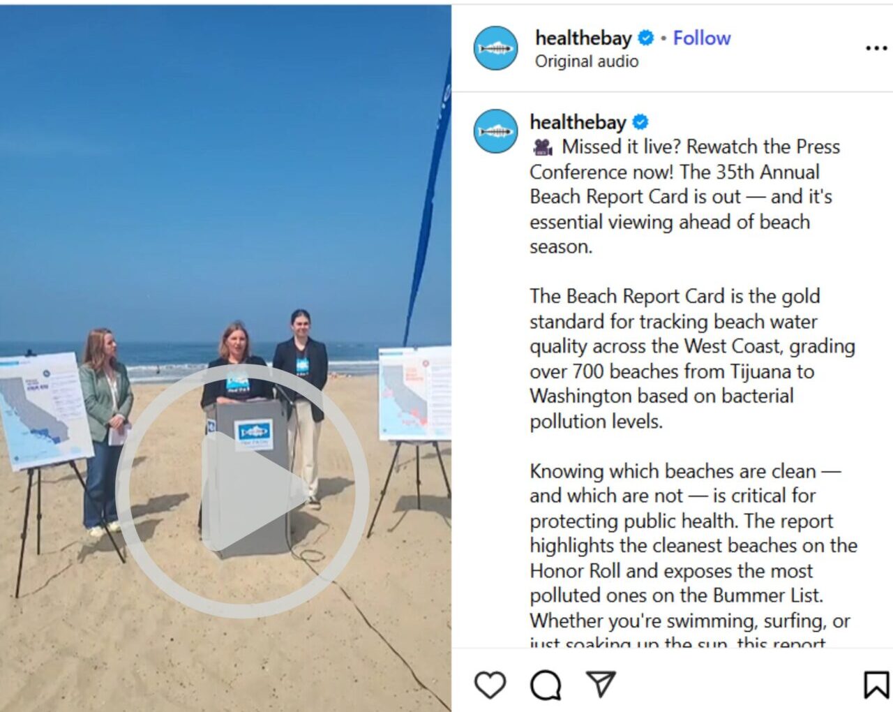
Summer is officially here – the peak season for swimming outdoors. Heal the Bay releases its annual scientific report on bacterial-pollution rankings for hundreds of beaches in California.
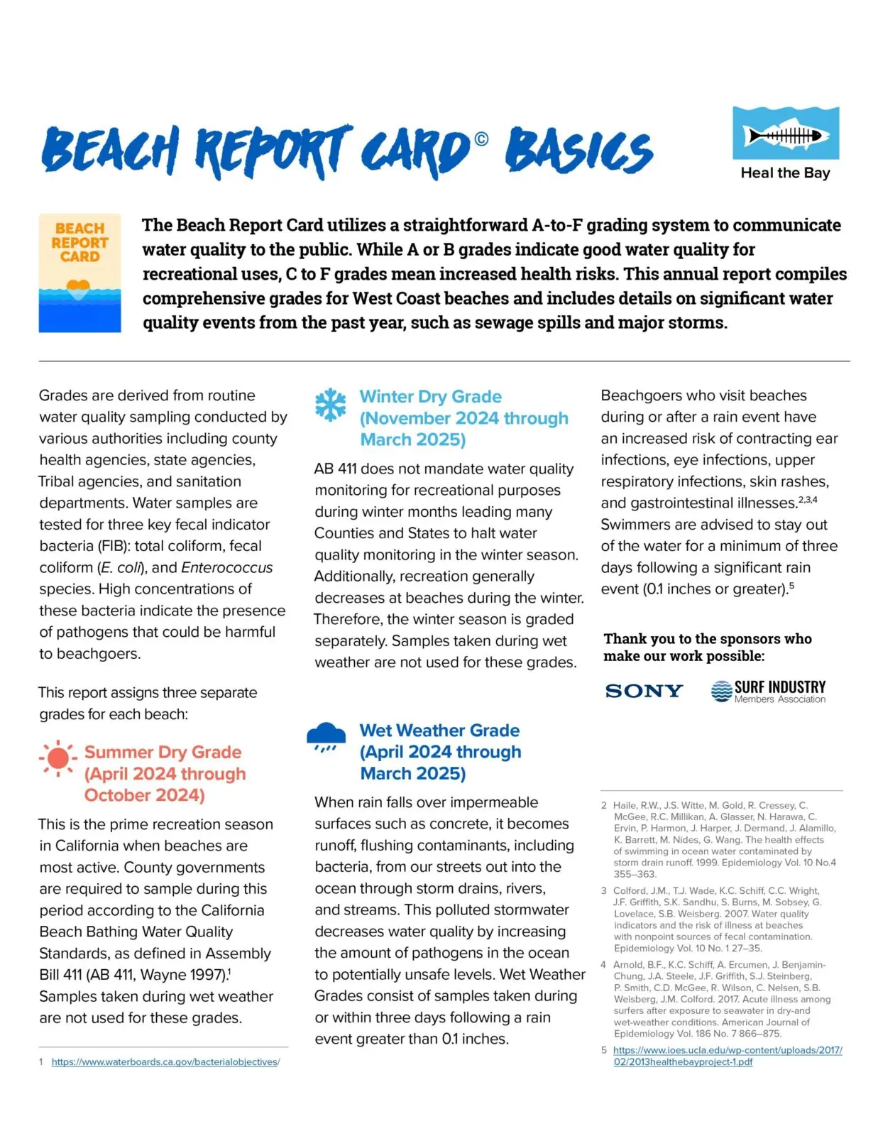
For more than 30 years, Heal the Bay has assigned annual “A-to-F” letter grades for 700 beaches from Washington State to Tijuana, Mexico, including 500 California beaches in the 2024-2025 report, based on levels of fecal-indicator bacterial pollution in the ocean measured by County health agencies. The public can check out the updated water quality of their local ocean beaches at beachreportcard.org or by downloading the app on their smartphone.
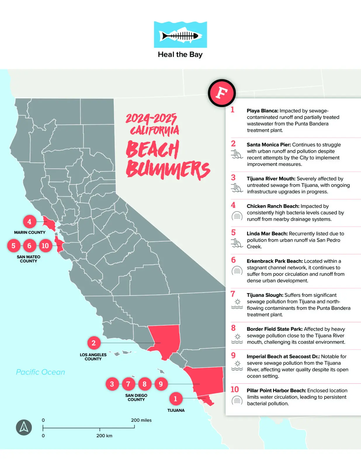
BEACH BUMMER LIST
Heal the Bay’s Beach Bummer List ranks the most polluted beaches in California based on levels of harmful bacteria in the ocean.
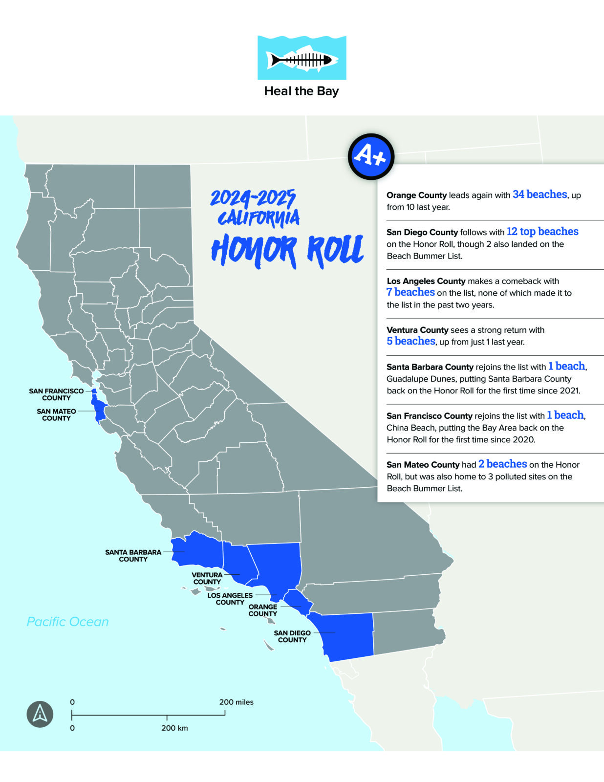
BEACH HONOR ROLL LIST
This year, 62 out of over 500 monitored beaches in California earned a spot on the Honor Roll, a significant improvement from just 12 beaches last year and only two in 2022–2023. This return to a higher Honor Roll count reflects levels more consistent with the reporting five
years ago. The increase in beaches on the Honor Roll this year is likely attributed to less overall rainfall during the 2024–2025 winter season, leading to substantially improved overall coastal water quality.
Avoid shallow, enclosed beaches with poor water circulation.
Swim at least 100 yards away from flowing storm drains, creeks, and piers.
Stay out of the water for at least 72-hours after a rain event.
Follow all local health and safety regulations, including all local pandemic-related regulations.
Check in with the lifeguard or ranger on duty for more information about the best places to swim.
Stay in the know! This year, the annual reports received state and national coverage – appearing in the New York Times, LA Times, and Associated Press.
ACCESS TO WATER RECREATION
The COVID-19 pandemic, record-setting wildfire seasons, and extreme heat have compounded the already dire need for equity in our recreational waters, and exposed major systemic failures; open spaces, including beaches and rivers, are not equally accessible to all people. Low-income communities of color tend to be the most burdened communities, bearing the brunt of environmental pollution, socioeconomic disparities, and limited access to safe, healthy, and clean water recreation. Heal the Bay is committed to expanding the user base of our Beach Report Card and River Report Card. We have started by working with local community-based organizations that are taking down barriers to water recreation for communities of color. Through this work, we will amplify what “safe, healthy, and clean access to water recreation” means in the communities where it is needed the most.
About Heal the Bay: Heal the Bay is a 501(c)3 nonprofit organization founded in 1985. They use science, education, community action, and advocacy to fulfill their mission to protect coastal waters and watersheds in Southern California with a particular focus on public health, climate change, biodiversity, and environmental justice. Heal the Bay Aquarium, located at the Santa Monica Pier, welcomes 100,000 guests annually and hosts a variety of public programs and events that highlight local environmental issues and solutions. Learn more at healthebay.org and follow @healthebay on social media or watch this short video.
The Beach Report Card Heal with NowCast, in partnership with SIMA Environmental Fund, and SONY Pictures Entertainment, is Heal the Bay’s flagship scientific water quality monitoring program that started in the 1990s. For more than thirty years, the Beach Report Card has influenced the improvement of water quality by increasing monitoring efforts and helping to enact strong environmental and public health policies. Learn more at beachreportcard.org and download the free app on Apple and Android devices. The Beach Report Card is made possible through generous support from SIMA Environmental Fund and SONY Pictures Entertainment.
About River Report Card: Currently, there is no statewide water quality monitoring mandate for rivers and streams in California, like exists for the ocean as a result of the Beach Report Card. Heal the Bay started the River Report Card in 2017 to push for new public health protections for freshwater areas in addition to serving the immediate need for increased public awareness about the risks at popular freshwater recreation areas in Los Angeles County. Learn more at healthebay.org/riverreportcard. The River Report Card is supported by Environment Now.
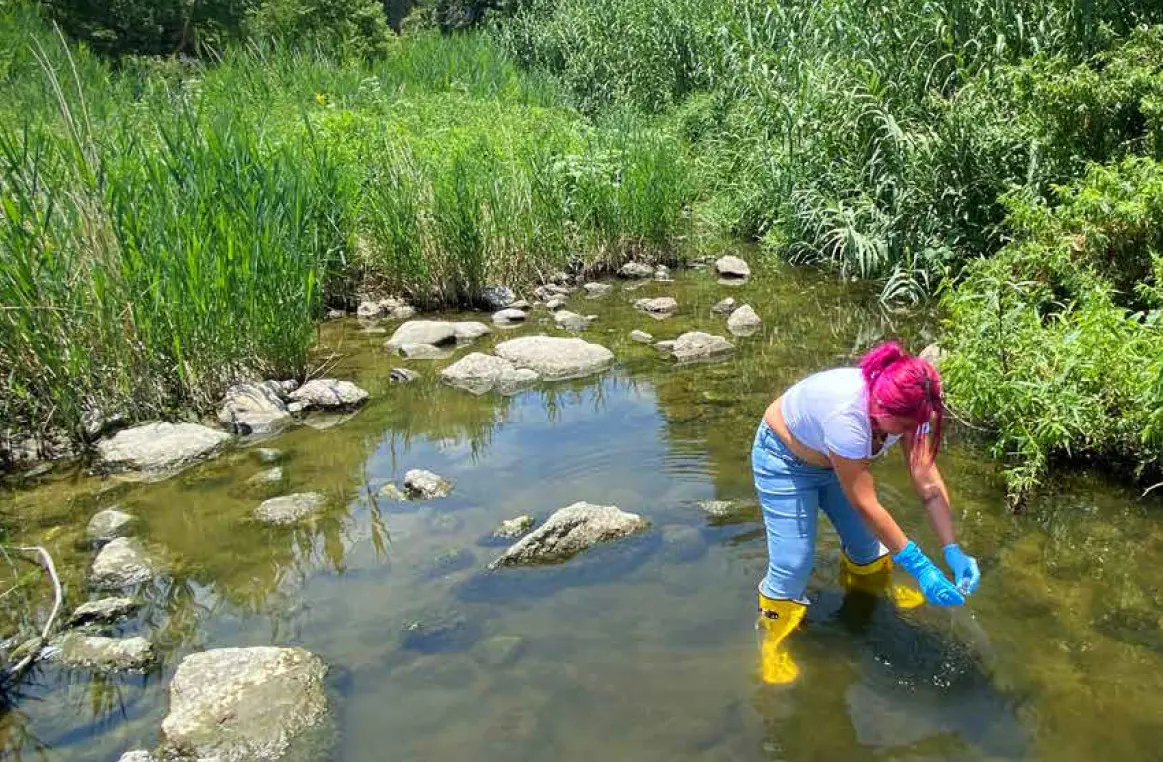
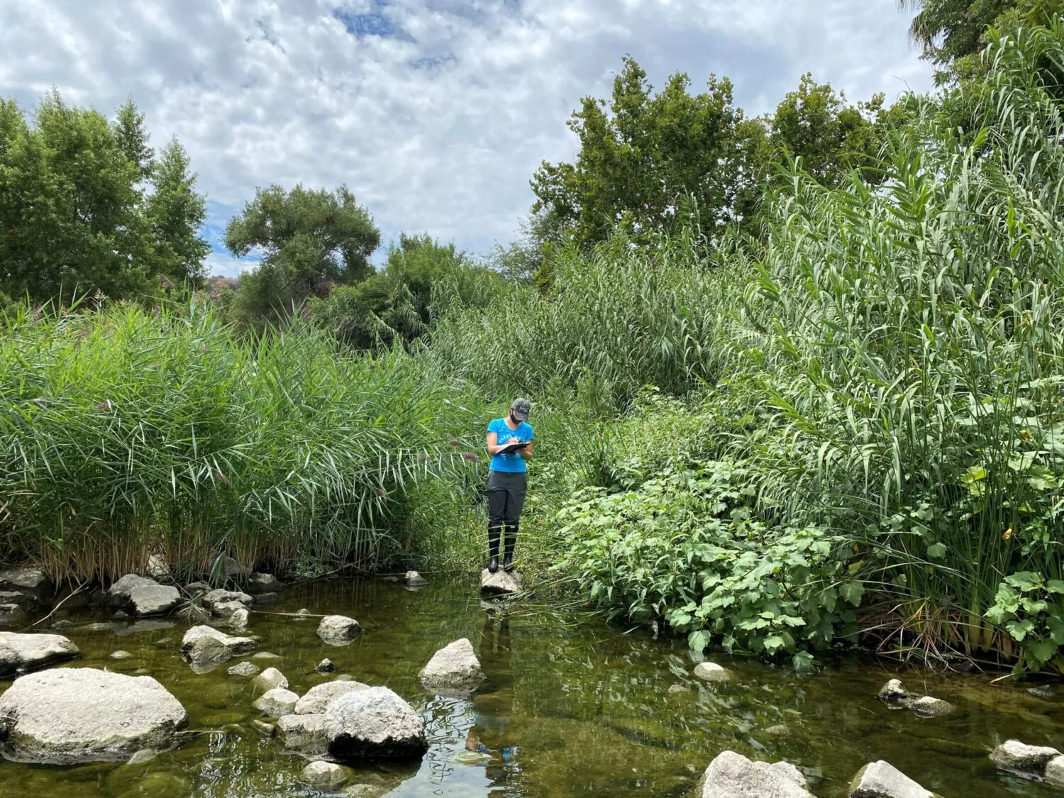
Freshwater sites in L.A. County suffer from fecal indicator bacteria (FIB) pollution, indicating harmful pathogens that can lead to serious illness. FIB pollution often stems from urban runoff, illegal discharges, and leaks from failing wastewater systems. In response to the lack of publicly available information, Heal the Bay launched monitoring efforts in 2014, culminating in the River Report Card (RRC) in 2017, to keep freshwater sites safe for recreation.
The RRC offers free, weekly water quality grades for 35 freshwater recreation sites, providing essential information to safeguard public health. In addition to these weekly updates, Heal the Bay releases an annual report each summer.
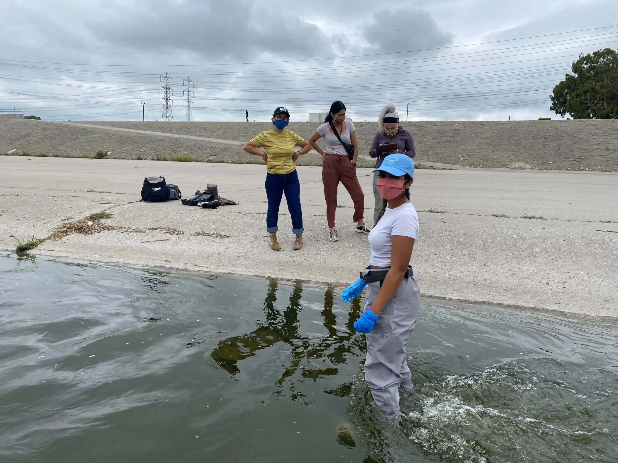
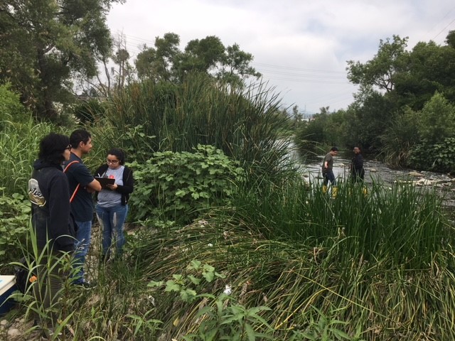
The program also supports local students through the Stream Team initiative, which trains participants in field and lab techniques to prepare them for STEM careers. Since its inception, 57 students have contributed to monitoring efforts, expanding from Malibu Creek State Park to the L.A. River Watershed and beyond, including storm drain testing in the Elysian Valley, where dry weather urban runoff enters the river via storm drains. This initiative aims to identify and address potential sources of contamination that could impact water quality in the L.A. River and surrounding environments.
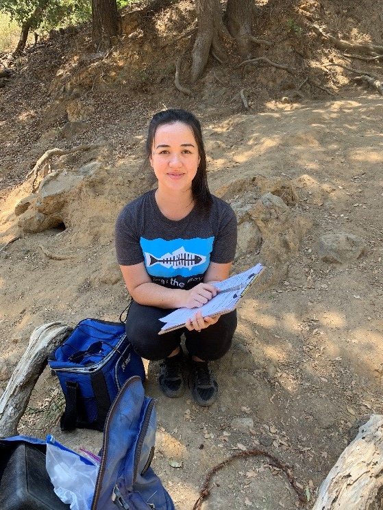
2024 Lower LA River Stream Team (from left to right: Vina Rose Matias, Emily Uy, Danny Herrera, Zaria Alam, and Ellie Garcia)
Summer 2024 Recap
Heal the Bay welcomed 14 students from colleges across Southern California for the Stream Team internship this summer. Over 16 weeks, the team collected over 150 water samples and evaluated nearly 700 water quality grades, revealing trends at 35 testing locations monitored by HTB, SGRMP, and LA Environment and Sanitation (LASAN). Grades this summer were similar to past summers, with sites higher in the watershed, such as the San Gabriel River locations, receiving better grades and sites lower in the watershed, such as the lower L.A. River, receiving worse grades.
In addition to hands-on training, interns engaged in science communication, writing blog posts about their experiences, and participating in community events like the Friends of the Los Angeles River Festival. They also learned about career opportunities in environmental science from guest speakers and researchers at the EPA, LA Water Quality Control Board, and U.C. Riverside.
Heal the Bay monitors water quality through these efforts and cultivates the next generation of environmental stewards. For the latest grades, visit the River Report Card website. A full report will be available early next year.
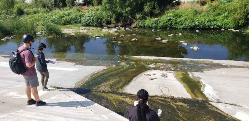
Stream Team members Blaire Edwards and Kate Medrano are sampling at Los Angeles River at Benedict St.
2024 Upper LA River Stream Team (from left to right: Sanam Viliani, Lyanne Fernandez, David Martinez, Kate Medrano, Blaire Edwards, Vicente Villaseñor)
2024 Malibu Creek Stream Team (from left to right: Blaire Edwards, Alejandra Miranda, Amy Flores, Thais Arata)
Students provided insight on their favorite sections of the LA River:
“My favorite part of the LA River is the Lower LA River. It’s definitely not the cleanest, as illustrated in the grades these sites often receive, and not the most visually appealing. However, I find it’s incredibly diverse with both flora and fauna. The bird species in particular, especially at Willow, were always abundant. There was definitely a lack of human activity most likely due to sanitation and lack of aesthetics for recreational use, but that didn’t stop the river from doing its job for the other inhabitants of LA. I especially liked collecting field data at Willow because it was a hotspot for a variety of shorebirds.” – Ellie Garcia, Lower LA River Team
“My favorite part of the L.A. River is around Frogtown. There are a lot of people walking around, biking, enjoying nature, and the businesses adjacent to the river. I also appreciated how busy the area is throughout the day. We usually start at 8 AM and end at 12 PM collecting samples and the area is never quiet or empty.” – Vicente Villasenor, Upper LA River Team
“My favorite part of the LA River is how quickly it can change. The one I’d see change significantly every week was Sepulveda Basin, making it my favorite sampling site. Every week I noticed it became lusher than it had been the first time we visited the site.” – Kate Medrano, Upper LA River Team.
Students also shared what they learned about these urban waterways and water quality testing, and the importance of this water to the communities of humans and other species who live in and around the river:
“I learned more about how the river is an essential part for the community. I understood already that the river is important for wildlife. If its quality goes down, it has a domino effect on the environment. This season I learned that the domino effect also affects the community. I used to view the lower LA river as a sewage line, but while taking samples this season, I seen that it is also used for recreation. For example, people run, ride their bikes, and walk their dogs along the river. People also bird watch. I believe this further brings reason on why we need policy to protect this river and make it better. It’s vital in uplifting our community further.” – Vina Rose Matias, Lower LA River Team
“As a second-year intern, I was already quite familiar with the sampling process. However, this season we accounted for the different bird species present in the Lower LA River in our field data. I learned more about the migration patterns of native and non-native birds that call LA home and experienced the visual difference of biodiversity that came along with this. With this, I learned just how important the LA river is to these migratory birds. It acts almost like a home base for those that nest in this area. My most interesting finding had to be the Egyptian Geese we ran into during the end of our sampling season. They were very vocal, very colorful, and a bit too bold with people! They got a little too close while during sampling in Willow, which was interesting!” – Ellie Garcia, Lower LA River Team
Impact
Heal the Bay has maintained strong partnerships with the State Water Resource Control Board’s Clean Water Team, Los Angeles Trade Technical College, and California State University Long Beach. These collaborations have expanded our programs, providing essential laboratory resources and expertise while actively recruiting students for our Stream Team. This initiative equips students with practical skills and empowers them as future environmental leaders.
UC Riverside graduate researcher John Perna explains to the Stream Team how microplastics collection and research is completed along the LA River.
Through our partnerships, Heal the Bay improves understanding of water quality issues and advocates for public health measures. Our data collection has led to enhanced monitoring by LASAN and the establishment of a dedicated webpage by the L.A. County Department of Public Health for freshwater recreation areas.
Heal the Bay continues to push for legislation that mandates comprehensive water quality testing at freshwater sites, similar to existing beach testing standards. In 2021, we took a significant step forward with the successful sponsorship of AB 1066, which aims to establish a statewide water quality monitoring program at freshwater recreation areas.
Summer is officially here – the peak season for swimming outdoors. Heal the Bay releases its annual scientific reports on bacterial-pollution rankings for hundreds of beaches in California and dozens of freshwater recreation areas in Los Angeles County.
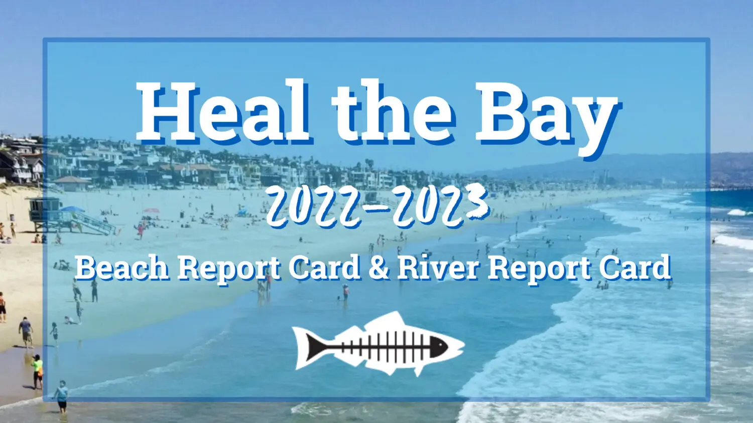
For more than 30 years, Heal the Bay has assigned annual “A-to-F” letter grades for 700 beaches from Washington State to Tijuana, Mexico including 500 California beaches in the 2022-2023 report, based on levels of fecal-indicator bacterial pollution in the ocean measured by County health agencies. In addition, since 2017, the organization has ranked freshwater quality, releasing report grades for 35 freshwater recreation areas in Los Angeles County for summer 2022 in its fifth annual River Report Card. The public can check out the updated water quality of their local freshwater recreation areas at healthebay.org/riverreportcard and ocean beaches at beachreportcard.org or by downloading the app on their smartphone.
BEACH REPORT CARD HIGHLIGHTS
The good news is 95% of the California beaches assessed by Heal the Bay received an A or B grade during summer 2022, which is on par with the average.
Even so, Heal the Bay scientists remain deeply concerned about ocean water quality. Polluted waters pose a significant health risk to millions of people in California. People who come in contact with water with a C grade or lower are at a greater risk of contracting illnesses such as stomach flu, ear infections, upper respiratory infections, and rashes. Beaches and rivers usually have poor water quality following a rain event. More rain typically means that increased amounts of pollutants, including bacteria, are flushed through storm drains and rivers into the ocean. Sewage spills pose increased health risks and trigger immediate beach closures, which should be heeded until public officials clear the area. Last year an astounding 45 million gallons of sewage were spilled and made their way to California beaches. Only 56% of California beaches had good or excellent grades during wet weather, which was worse than average, and very concerning.
“As climate change continues to bring weather whiplash, our water woes will swing from scarcity to pollution. This year, record precipitation produced major impacts on water quality across Coastal California,” said Tracy Quinn, President and CEO of Heal the Bay. “Now more than ever, we must prioritize multi-benefit projects to manage stormwater as both a water quality and supply solution, all while ensuring that the public is kept informed of risks to public health.”
Heal the Bay’s Beach Report Card and River Report Card provide access to the latest water quality information and are a critical part of our science-based advocacy work in support of strong environmental policies that protect public health.
Heal the Bay’s Beach Bummer List ranks the most polluted beaches in California based on levels of harmful bacteria in the ocean. The 2022-2023 Beach Bummer List includes beaches in Los Angeles, San Mateo, San Diego, and Orange Counties as well as the Tijuana Area. This year, Santa Monica Pier and Playa Blanca in Tijuana tied for the top spot as both faced significant water quality challenges.
1-2. Playa Blanca, Tijuana Area
1-2. Santa Monica Pier, LA County
3. Linda Mar Beach, San Mateo County
4. Marlin Park, San Mateo County
5. Erckenbrack Park, San Mateo County
6. Tijuana River Mouth, San Diego County
7. Pillar Point Harbor, San Mateo County
8. Marina del Rey Mother’s Beach, LA County
9. Poche Beach, Orange County
10. Gull Park, San Mateo County
BEACH HONOR ROLL LIST
This year, only two out of over 500 monitored beaches made it on the Honor Roll compared to 51 last year. Unfortunately, the unprecedented amount of rain that fell across California during the 2022–2023 winter led to an enormous dip in water quality and a very short Honor Roll list. The Honor Roll is typically dominated by Southern California beaches, in part, because many Northern and Central California Counties do not monitor beach water quality year-round. However, it appears that the wet weather from this past winter took its toll everywhere.
Point Loma, Lighthouse, San Diego
Bean Hollow State Beach, San Mateo
The record rainfall impacted the Honor Roll list in two ways: 1) fewer beaches received Winter Dry Grades because most of the winter data was collected during wet weather, and 2) increased precipitation negatively impacts water quality. In order to get on the Honor Roll, a beach must have zero bacterial exceedances all year under all conditions, which is extremely difficult to do with so much rainfall. The unsettlingly short Honor Roll was also impacted by our inability to grade one third of San Diego County’s beaches, which usually comprise a large portion of the Honor Roll (15 in the last report). in 2022 San Diego agencies began using a new testing method for bacterial pollution at nearly a third of beaches in the County, which is unfortunately not yet compatible with our grading methods in the Beach Report Card. Find out why we couldn’t grade nearly a third of San Diego beaches in the full report.
RIVER REPORT CARD HIGHLIGHTS
Heal the Bay graded 35 freshwater recreation areas in Los Angeles County within the L.A. River, San Gabriel River, and Malibu Creek Watersheds during summer 2022. Across all 35 sites and all dates graded throughout summer 2022, 65% of grades were Green (indicating no water quality health risks); 15% were Yellow (moderate health risk), and 19% were Red (high health risk). This was an improvement from the previous year.
We are thrilled to be debuting a new method for grading freshwater quality in summer 2023 in our weekly grades that are online. The method was developed with the help of a team of water quality experts and will use the same letter grading system (A-F) as the Beach Report Card to improve user experience and reflect the latest science.
“Our River Report Card identifies a disturbing trend between development and water quality. The natural areas in our watersheds, rivers and streams with muddy or sandy bottoms and ample flora, typically have the best water quality and are the safest for the public. In contrast, heavily developed areas, waterways encased with concrete (including within the L.A. River channel) and stormdrain inputs, tend to have lower water quality. We recommend checking out the River Report Card before heading out to the L.A. River because bacteria levels are often at unsafe levels and you can find a safer spot for cooling off,” said Dr. Alison Xunyi Wu, Water Quality Data Specialist and co-author of the River Report Card and Beach Report Card.
Top 10 river recreation sites in Los Angeles County that are high-risk places to contact the water. Note: Three sites are tied for number 1 Freshwater Fails.
1-3. L.A. River at Riverfront Park
1-3. Compton Creek
1-3. Tujunga Wash at Hansen Dam
4. L.A. River below the Rio Hondo Confluence
5. L.A. River at Willow St.
6. L.A. River at Hollydale Park
7. L.A. River below the Compton Creek Confluence
8. Bull Creek
9. Lake Balboa Boat Ramp
10. Las Virgenes Creek
FRESHWATER HONOR ROLL LIST
Top 10 river recreation sites in Los Angeles County that are low-risk places to swim or boat. An impressive eight sites tied for number 1 with 100% Green grades all summer.
1-8. San Gabriel River East Fork at Graveyard Canyon
Avoid shallow, enclosed beaches with poor water circulation.
Swim at least 100 yards away from flowing storm drains, creeks, and piers.
Stay out of the water for at least 72-hours after a rain event.
Follow all local health and safety regulations, including all local pandemic-related regulations.
Check in with the lifeguard or ranger on duty for more information about the best places to swim.
Stay in the know! This year, the annual reports received state and national coverage – appearing in the New York Times, LA Times, and Associated Press.
ACCESS TO WATER RECREATION
The COVID-19 pandemic, record-setting wildfire seasons, and extreme heat have compounded the already dire need for equity in our recreational waters, and exposed major systemic failures; open spaces, including beaches and rivers, are not equally accessible to all people. Low-income communities of color tend to be the most burdened communities, bearing the brunt of environmental pollution, socioeconomic disparities, and limited access to safe, healthy, and clean water recreation. Heal the Bay is committed to expanding the user base of our Beach Report Card and River Report Card. We have started by working with local community-based organizations that are taking down barriers to water recreation for communities of color. Through this work, we will amplify what “safe, healthy, and clean access to water recreation” means in the communities where it is needed the most.
About Heal the Bay: Heal the Bay is a 501(c)3 nonprofit organization founded in 1985. They use science, education, community action, and advocacy to fulfill their mission to protect coastal waters and watersheds in Southern California with a particular focus on public health, climate change, biodiversity, and environmental justice. Heal the Bay Aquarium, located at the Santa Monica Pier, welcomes 100,000 guests annually and hosts a variety of public programs and events that highlight local environmental issues and solutions. Learn more at healthebay.org and follow @healthebay on social media or watch this short video.
Beach Report Card with NowCast, in partnership with World Surf League, is Heal the Bay’s flagship scientific water quality monitoring program that started in the 1990s. For more than thirty years, the Beach Report Card has influenced the improvement of water quality by increasing monitoring efforts and helping to enact strong environmental and public health policies. Learn more at beachreportcard.org and download the free app on Apple and Android devices. The Beach Report Card is made possible through generous support from SIMA Environmental Fund, SONY Pictures Entertainment, and World Surf League.
About River Report Card: Currently, there is no statewide water quality monitoring mandate for rivers and streams in California, like exists for the ocean as a result of the Beach Report Card. Heal the Bay started the River Report Card in 2017 to push for new public health protections for freshwater areas in addition to serving the immediate need for increased public awareness about the risks at popular freshwater recreation areas in Los Angeles County. Learn more at healthebay.org/riverreportcard. The River Report Card is supported by Environment Now.
On warmer days when people are spending time outdoors in Los Angeles, Heal the Bay is there too, collecting water samples from rivers, creeks, and streams. Our River Report Card has issued water quality grades for freshwater recreation sites throughout LA County since 2017. The grades are based on levels of bacterial pollution in the water, and help the public make informed decisions about whether it’s safe to swim there. Local college students (our ‘Stream Team’) collect water samples from Malibu Creek State Park and the LA River in the San Fernando Valley and north of Downtown.
This fantastic achievement would not be possible without the hard work of our Lower LA River Stream Team, which is composed of five students from CSULB and Long Beach City College (LBCC).
We asked the students to share their thoughts on the work they did this past summer – read on to hear their voices and what this experience meant to them.
Sarah Valencia
“Throughout my entire experience with the Stream Team I learned so much about the activity surrounding the LA River. So many locals come out to enjoy the River and the space it has to offer. It made me realize how precious the River is to so many hidden communities and local families. Unfortunately, our samples collected from the lower part of the LA River yielded large amounts of E. coli and Enterococcus (which indicates the presence of fecal pollution). The River was not suitable or safe for any kind of in-water activities, so seeing locals try to catch fish or bathe in the water made our work feel needed and long overdue.
I grew up in Bell, California, just about a block from Riverfront Park. I remember hanging out by the River with friends, so I feel connected to the River in that it is part of my community and childhood. Joining the Stream Team helped me look at the LA River through different lenses. I can now see how the River is an integral part of the ecosystem there especially as we move closer to the ocean where the River ends. Animals were always a fun sight. We’d randomly find a snake, turtle, frog, and countless dogs. Each field day was its own new adventure.
I hope to continue my education in environmental science by attending graduate school so that I can take my knowledge and studies into helping watershed conservation and communities. I believe that the work the Stream Team does will prompt legislatures, other conservation groups, and the community to support efforts into watershed conservation and protecting the LA River for all its communities.”
Sarah Kambli
“I was so excited to have the opportunity to work as part of the Stream Team this summer. Originally a Marine Biology major, I switched to Environmental Science & Policy in the fall of 2019 and while I was excited at the new prospect, I wasn’t entirely sure what exactly this field would have in store for me. Cue the Stream Team! When I heard about this opportunity, I was so excited and jumped at the chance to apply, and I was absolutely elated when I got the position. I’ve always felt a connection to Nature, especially water, so to be able to get down into the River and study it was so exciting!
This project meant a lot to me in many ways. Scientifically, I was able to get some hands-on experience by collecting and analyzing samples. I was able to use some of the skills I learned in previous Science classes that, while enjoyable, I really struggled with. So, it really made me feel good to see that I was able to pull from some of that knowledge and put it to practical use, despite my previous difficulties. I gained so much confidence in myself through working both in the field and in the lab, and this experience showed me a potential road that I am excited to continue down after school. I’m still not completely sure what I want to do when I’m finished, but I know I want to work with ocean conservation; having this experience will really help me with that goal in the future.
On a personal level, this project also meant a lot to me. Like a lot of people, COVID has been very difficult for me. My entire family lives over a thousand miles away in the middle of the country, so I felt the forced isolation especially hard. When I joined the Stream Team, though, and got to work with these amazing young women, I felt myself come alive again. The five of us all got along exceptionally well from the start, and we worked seamlessly as a team. Besides amazing teammates, I made four wonderful friends that I foresee being in my life for many years down the road.”
Monet Pedrazzini
“Early morning air carries sounds of sweeping trucks on the 710 that mimic ocean waves, a foreshadowing of the eventual pelagic destiny of the Lower LA River runoff. We, the Stream Team, trudge in our waders and boots while taking note of cyclists and weekly algae bloom, watching dragonflies during the summer, and counting trash bags or shopping carts that decorate the concrete-floored watershed. Each site has its own expression of local flora, fauna, and activity. Families push strollers on the bike trail past the scattered duckweed and litter on the slopes of Riverfront Park’s riparian bank while Audubon Society members stake out at Willow (the furthest downstream site) to view Canadian geese or California terns taking a rest from migration commutes. As a part of Los Angeles history from early colonization to its present physical intertwinement that starts in Canoga Park, the LA River’s broad ecosystem spans time as well as the landscape with understatement. Shooting through downtown LA generally unnoticed and ending in Long Beach, it runs through and by us each day. The myth of nature as other erodes as we collect samples, commuting downstream, amongst the biodiversity and legacy of the LA River. We, as humans, are as much a part of this once wild river that’s laden with society’s trashy fingerprint as it is a part of us, as the watershed cycle flushes away our cityscape toxins like urban kidneys. Our connection is integrated, even interdependent.
Participating in routine, weekly visits cultivated an intimate relationship with each site, allowing us to more acutely observe seasonal shifts and differences in weather or time of day as patterns of the ecosystem. We learned to correlate these fluctuations with our lab analysis, excitedly putting into practice empirical observation along with the scientific method as we discovered the disappointing, but not so surprising, high levels of bacteria present in the River. This was each of our introductions to scientific field and lab work. Our worst fear was to feel intimidated, talked down to, or not smart enough to be there. Being an all-female team with varying abilities and backgrounds felt radically inclusive according to our understanding of the culture of STEM. With Heal the Bay’s encouraging support and example of relearning inclusivity in STEM, we intentionally empowered each other with compassionate accommodation that highlighted each member’s contributing strengths. Learning to practice consistency in standardized data collection and interpretive analysis as well as utilize unfamiliar lab equipment as a team allowed us to be more present, confident, and welcomed in the realm of science, transforming the fearful, projected legacy of competition into collaboration.
These embracing qualities have been so important to each of us as our initiating experience with scientific research. The opportunity to engage with science without feeling judged or insecure not only maintained a wholesome environment but has worked to affirm my own capacity, ability, and confidence to pursue a professional career in the STEM fields. Furthermore, as a Latinx, Long Beach native, relating data specific to my local ecosystems to the overarching narrative of climate change and environmental justice is a priority. Given this, my goal is to utilize my degree to advocate for Indigenous Land reclamation and stewardship in the process of decolonization along with environmental advocacy while continuing to nourish inclusivity in STEM. Working with Heal the Bay on the Lower LA River Stream Team has provided an incredible launching pad of curiosity, partnership, empowerment, and insight into the praxis of scientific pursuits. My experience with the LA River will always be a deep, personal reminder of the poetic resiliency and adaptive character of nature, moving me to remember that nature is not only all around us but more so, we have merely built ourselves around nature.”
Melissa Zelaya
“My time spent learning about the Lower LA River these last few months has been incredibly informative and inspirational. I was lucky to be part of the Stream Team which included a wonderful array of individuals that I learned from each day. Also training under Luke and meeting a community of like-minded individuals has been fuel to my already blazing need to work towards the health and protection of our natural environment.
I discovered that to understand the importance of monitoring the Lower LA River is to understand the importance of all the connecting waterways. The seriousness of a rainfall washing through these connecting channels bringing all the waste of our city to the ocean is one of the reasons it is instrumental in seeking ways we can make better changes. Not only were we able to see firsthand what rainfall does to the River but we were also able to quantify the difference it makes in our data. Monitoring the Lower LA River was challenging at times. Even though it holds the title of a river and is used recreationally, what we noted was a heavily impacted area not held to safe health standards. The qualitative data we recorded revealed that there is movement of birds as well as local activity using this area as recreational pathways. We saw fishes, insects, algae, vegetation, and life in and near the River. Our mission to the River was for the entirety. To advocate for those who cannot speak for themselves and to show the results of our current standing so that we can see positive improvements of the natural aspect of this area.
The direction of my personal and professional life has always been intertwined. As a first generation Latina college student, it was exciting being able to come home and explain to my parents the work I was doing in the River. My passion for my study came from their encouragement and compassion. I want to use my time and voice in ways that can be beneficial to the community and in the protection of the environment. I felt privileged to be able to do work that I loved at this point in my educational career. In addition, knowing that I would be gaining experience working with Heal the Bay who commits their time and resources to public health, climate action and education has been rewarding. I want to continue in this path that has been nothing but fulfilling. In educating others, as others have educated me. To advocate for an equitable future and use my training in ways that are going to help our diverse community flourish. I’ve been able to grow my confidence as well as knowledge of what it means to be a scientist thanks to an encouraging group putting work every day to see a better tomorrow.”
Jasmine Sandoval
“Hi, my name is Jasmine Sandoval and I had an amazing time being a part of the Stream Team this summer/fall! I am currently working on my Bachelor’s in Environmental Science and Policy, minor in Geology, and GIS certificate at Cal State University of Long Beach so this opportunity was right up my alley. During this time, I learned a lot about how to use lab equipment, how to set up, clean up, and perform testing on water samples, and how to take proper samples that would not introduce any bias or obstruct the sample as a whole. I also learned how to properly record data that is being collected! Working with the entire Stream Team has been such a blessing as the colleagues I worked with helped create such a fun, supportive, and respectful work environment. This whole experience has been so meaningful to me as it has helped me see how capable I am as a person, how much I love the field I am getting into, and how much work there is to be done that I can be involved in. I will take everything I learned from this and apply it to my future endeavors and for that I am truly grateful!”
The Stream Team will be back to issuing water quality grades next summer. In the meantime, keep an eye out for our annual River Report Card, which will be released in late spring 2022. Here’s our last report from 2020.
UPDATE: The AB1066 bill has passed and is heading to the Governor’s desk to sign! Thank you for making your voice heard on behalf of clean freshwater in California.
Heal the Bay and Assembly Member Richard Bloom Introduce Legislation to Protect Public Health at Freshwater Swimming and Recreation Sites in California
We are so excited that Assembly Bill 1066 is progressing through the State legislature. It is the necessary first step towards protecting all Californians from pollution at their favorite freshwater recreation spots, and it has the potential to inspire more health protections and water quality improvements as we have seen at our ocean beaches.
Take Action and Call Your Reps:
Help us ensure AB1066 passes by callingyour California representatives and letting them know you support safe, freshwater swimming sites for ALL!
Don’t know who your reps are or how to contact them? Find your reps here. Click the provided link to go to their websites and contact info.
Sample call script: “Hi, my name is ___ and I live in ___ . As your constituent, I am urging you to please support clean water, safe freshwater recreation, and public health by voting YES on AB1066. Thanks for your time.”
Learn More About Assembly Bill 1066
Assembly Bill 1066 has been amended since its initial introduction. The scope of the bill has been reduced, but it still remains a critical and significant step forward in protecting the public health of inland communities and visitors to freshwater recreation areas. The reduced scope cuts down on the cost and approaches the issue in phases, tackling phase one in its current version and extending the initial timeline.
Defining and identifying priority freshwater recreation sites across the state, based on criteria such as frequency of use and equity-based metrics
Making recommendations for an appropriate monitoring program for these sites to the State Water Board
If AB1066 passes, future steps, which Heal the Bay is committed to working on, would include:
Developing and mandating a monitoring and public notification program for priority freshwater recreation areas across California (similar to AB411 for ocean beaches)
Identifying appropriate funding sources to support this new program, such as a state budget allocation or federal funding
Twenty-four years ago, the California Legislature took an important step forward in protecting public health at ocean beaches. AB411, authored by Assembly Members Howard Wayne (San Diego) and Debra Bowen (South Bay), established statewide water quality standards, required standard monitoring protocols, and set uniform mandatory public notification procedures in place during poor water quality events. Prior to AB411, ocean-goers did not have access to water quality information leaving them vulnerable to serious illnessessuch as stomach flu, respiratory illness and debilitating ear, nose, and throat infections, which are contracted from fecal contamination in the water.
AB411 requires weekly water quality monitoring from April 1 to October 31 as well as public notification of water quality conditions for beaches where annual visitation is 50,000 or greater or that are near storm drains. Heal the Bay was the primary sponsor for this bill, and ourBeach Report Card, started in 1991, helped grow support for it. AB411 is still the guiding piece of legislation for recreational water quality monitoring in California. Unfortunately, freshwater swimming and recreation areas are not regulated or monitored consistently in the same way that ocean beaches are. California has fecal pollution standards for freshwater, but monitoring for that pollution is lacking. Many swimming holes across the State are not tested for water quality, and for those that are, the monitoring and public notification protocols are not consistent statewide.
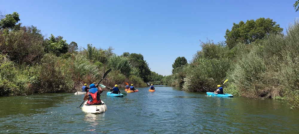
Rivers, lakes, and streams are popular areas where people swim, fish, kayak, wade, raft, and more. And for many people who do not live near the coast or for whom the coast is not easily accessible, these are the areas where they go to cool off and enjoy time with friends and family, and have a good time. People who visit freshwater swimming holes should be provided with the same protections that ocean beachgoers are given. People deserve to know if they might be exposed to fecal pollution so that they can adequately protect themselves. We are thrilled to announce that Assembly Member Richard Bloom, in partnership with Heal the Bay, has introduced legislation to address this public health disparity, AB1066.
AB1066 is the latest effort from Heal the Bay on addressing this issue. In 2014, Heal the Bay began monitoring freshwater recreation sites and providing that information to the public. We also began aggregating freshwater monitoring data from throughout LA County starting in 2017. This grew into our River Report Card (RRC), a free and publicly accessible website with updated water quality information throughout the greater LA region. Similar to the Beach Report Card, we have been using the RRC to advocate for increased monitoring and better water quality notifications across LA County. However, we want to take this to the next step and ensure people across the whole state have access to consistent water quality information that can help keep them safe.
AB1066 would:
Establish a definition for afreshwater recreation site based on frequency of use and identifysites state-wide to be monitored;
Require weeklymonitoring from Memorial Day to Labor Day for freshwater recreation sites by the owner/operator using a standardized protocol and metrics;
Require public notification online and through signage for hazardous water quality conditions.
“I am pleased to author AB1066 to address a key public health challenge that many Californians face in outdoor recreation– ensuring there are science and health based bacterial standards, ongoing water quality monitoring, and public notification for freshwater bathing where needed.
California is a magnificent state and one that affords all our communities with opportunities to recreate outdoors. Our lakes, rivers and streams should be enjoyed by residents throughout the state, but we need to ensure that their public health is protected while doing so.”
-Assembly Member Richard Bloom
The protections in AB1066 are long overdue and were afforded to ocean beaches nearly 25 years ago. Sign up for our newsletter to stay informed on our work and ways to get involved.
Luke Ginger, Water Quality Scientist at Heal the Bay, recaps a tough summer for water quality monitoring at LA County’s freshwater recreation areas, and outlines the urgent need for equitable, climate-resilient communities in the face of a health pandemic, extreme heat, unprecedented wildfires, and beyond.
Heal the Bay concludes another summer of freshwater sampling and monitoring with the River Report Card. Over the course of the summer of 2020, we provided inland water-goers with water quality grades for 27 freshwater recreation sites across Los Angeles County, California. This included 5 sites in Malibu Creek State Park and the LA River, where Heal the Bay staff collected water quality samples. We updated grades on a weekly basis and posted them online to be viewed by the public.
Summer 2020 was filled with many challenges that impacted our program. Due to COVID-19, Heal the Bay was unable to hire local college students to monitor water quality at recreation sites and storm drains like in previousyears. Instead, Heal the Bay’s permanent staff carried out water sampling. This was a major blow to our program because one of our main goals has always been to provide knowledge, skills, and career training to emerging professionals. Additionally, without a full crew, we sampled fewer recreation sites and storm drains, leaving the public with less information on how to stay safe.
We also had to take extra precautions while sampling – wearing masks at all times, driving in separate vehicles, and sporting extra protective gear (face shields and extra-long gloves) to reduce exposure to potentially contaminated water. These were necessary precautions because the research on the risk of contracting COVID-19 from recreational waters is still ongoing.
Photo by Alice Dison
There were also major changes in accessibility and use this summer at the sites Heal the Bay monitored. Malibu Creek State Park was open all summer, but the swimming holes (Rock Pool and Las Virgenes Creek) remained closed due to concerns over the ability to maintain proper physical distancing. However, this closure was not clearly enforced as we saw many swimmers throughout the summer. The official LA River recreation zones were open from Memorial Day until the end of September, but kayaking was not allowed due to safety concerns around COVID-19.
Monitoring efforts by LA Sanitation, Council for Watershed Health, and San Gabriel Regional Watershed Monitoring Program were impacted this summer as well. There were weeks where certain recreation sites in the Upper LA River Watershed and San Gabriel River Watershed were not monitored due to park closures or overcrowding concerns. According to LA Sanitation officials, Hermit Falls was not monitored this summer because it is a particularly crowded area that posed a health risk to the water quality monitors. Worker safety is incredibly important, as is the health of all Angelenos and visitors. Unfortunately, these tough decisions resulted in critical water quality information not being available at a very popular location all summer. LA Sanitation instead sampled the Vogel Flats picnic area, which is a new addition to the River Report Card. Toward the end of the summer, monitoring in the San Gabriel River Watershed and some of the Upper LA River Watershed was cut short due to the Bobcat Fire and the subsequent closure of Angeles National Forest.
This summer, the pandemic, a record setting wildfire season, and extreme heat culminated into one even larger public health crisis. The pandemic forced people to stay local and opt for close-by areas to take a swim. Because of this, as well as the reduced risk of contracting COVID-19 outdoors, people flocked in unusually high numbers to ocean beaches and freshwater recreation sites to stay active and cool. Unfortunately, if outdoor crowds become too big and dense, there is an increased risk of COVID-19 spread. The fact that so many people sought respite outside made clear the importance of open space for physical and mental health. But, the benefits of open space are not equally experienced by all. Black and Latinx communities have been systemically denied access to parks and nature, and there is a lot of work to do to provide justice for these communities. LA City and County must work hard to meet their target of 65% of Angelenos living within half a mile of a park or open space by 2025 (and 75% by 2035).
Photo by Alice Dison
The summer’s extreme heat waves coincided with the largest wildfires in California’s history, which created harmful air quality across the entire west coast. Many people endured hazardous outdoor air quality in order to cool off at rivers, streams, and beaches. Tragically, exposure to wildfire-induced poor air quality exacerbates the harmful health effects of COVID-19. So for low-income households without air conditioning, it was impossible to escape harm; people were either subject to extreme heat at home or subject to harmful air quality outside. We must acknowledge that in the United States, the communities facing the brunt of climate change impacts like extreme heat and wildfire are disproportionately Indigenous, Black, Hispanic, and Asian people.
Summer 2020 was a tough time for many, and it underscores the need for immediate and equitable action to address the climate crisis and environmental justice.
Looking forward, Heal the Bay will continue to advocate for water quality improvements across LA County, so everyone is protected from waterborne illness. And, we will continue to push for nature-based policies that stem the impacts of climate change and make our communities climate resilient.
Summer 2020 Results
Here are the water quality results from the sites Heal the Bay monitored during summer 2020.
Malibu Creek State Park
Rock Pool – did slightly better than last year
64% Green
35% Yellow
0% Red
Las Virgenes Creek – worse than last year
0% Green
93% Yellow
7% Red
Los Angeles River
Sepulveda Basin at Burbank Ave. – slightly better than last year
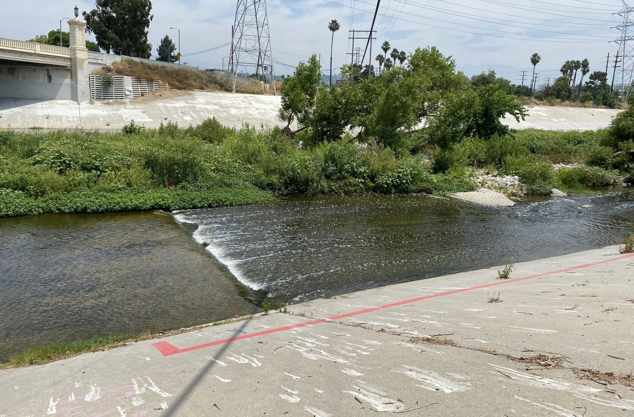
When I first visited Los Angeles in 2015, I was not interested in seeing the Hollywood Walk of Fame or the Hollywood Sign. Instead, I asked my local friends to take me directly to the L.A. River. I wanted to see the hallmark concrete embankments where so many movie car chases happened and the thin ribbon of water I watched my favorite skateboarders jump over (with mixed success).
The L.A. River has A-List status far outside of the Los Angeles area, and is recognized by people all over the globe. Its notoriety is mostly due to its unique appearance. It doesn’t look like a typical river at all, instead it looks like – and functions as – a storm drain channel.
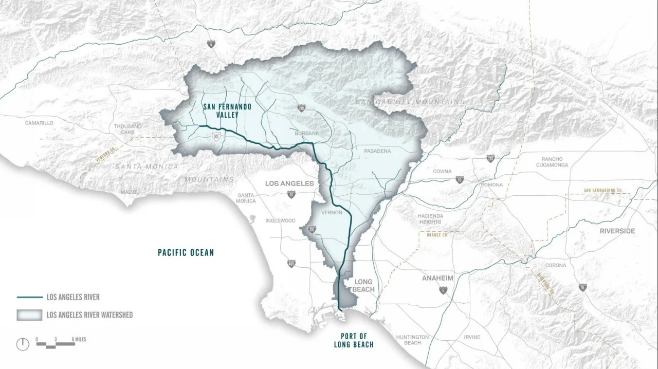
The L.A. River begins in Canoga Park where Bell Creek and Arroyo Calabasas converge, and it runs 51 miles through the City of Los Angeles and over 17 other cities, draining over 800 square miles of land, before it flows into the Pacific Ocean in Long Beach.
The History of the L.A. River
In pre-colonial Los Angeles County, water from rivers and streams naturally flowed and supported Tongva, Tataviam, and Chumash Peoples in the area. Later, the L.A. River and its tributaries supported the colonial settlements that were violently and coercively established on local Indigenous territories.
1800’s Before Colonial Settlement. Source: Seaver Central For Western History Research / Natural History Museum Los Angeles County, riverlareports.riverla.org
A population boom in the early 1900’s meant the L.A. River and its tributaries could no longer support the water demand for the area. Cities began sourcing water from the Colorado River and Northern California, and the L.A. River gradually went from being a vital local water source to being seen as a nuisance.
From 1900-1940 there were multiple floods of the L.A. River that destroyed neighborhoods and resulted in fatalities. The colonial cities along the river failed to respect the L.A. River as the Indigenous People had, and instead built homes and buildings within the River’s floodplain.
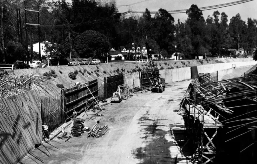
1938 Colfax Avenue Bridge Studio City. Source: Regional History Center / USC, riverlareports.riverla.org
In response to the floods, the U.S. Army Corps of Engineers decided to pour concrete over the sides and bottom of the L.A. River channel and its tributaries to create a network of concrete storm drain channels. The concretization of the river led to a reduction in flood risk because it forced water to flow much more quickly down the river and out to the ocean. But, the concrete completely decimated the river ecosystem and the services it once provided, including cultural value, habitat for wildlife, and greenspace for recreation.
After the river was concretized, Indigenous People, activists, and environmental organizations demanded the restoration of the L.A. River and its tributaries back into a functioning natural river ecosystem.
Now with the climate crisis, we can no longer afford to have a concretized river system that solely provides flood control. We need a river system that will help cool communities as temperatures rise, provide habitat for diverse wildlife, increase local water resiliency, and serve as a greenspace where communities can recreate and reconnect with nature and culture.
Government agencies have identified the need to re-establish all of the lost ecosystem services as well, and have implemented six major plans with the goal of transforming the L.A. River and its tributaries into a multi-benefit system that will serve the surrounding communities.
Here we summarize these plans and let you know how to get involved.
Los Angeles River Master Plan Update (LARMPU)
The LARMPU is a plan created by L.A. County with the goal of transforming the L.A. River. The original Master Plan was drafted in 1996, and its main goal was to beautify the river while maintaining its functionality as a stormwater conveyance system. The 2020 update of the Master Plan was set into motion to ensure the L.A. River has spaces that provide more benefits in addition to flood abatement and beautification. As stated in the plan, projects will reduce flood risk; improve parks and open space; improve river access; support the ecosystem; provide cultural and educational opportunities; address housing affordability and homelessness; improve local water resilience; and promote water quality.
Heal the Bay was selected to serve as a Steering Committee member for the update and has been attending meetings and offering feedback over the last two years. The updated Master Plan for the entire River is expected to be released to the public in the next few weeks as a draft open for public comments – stay tuned for updates on that and be ready to share your thoughts on the River and the Master Plan.
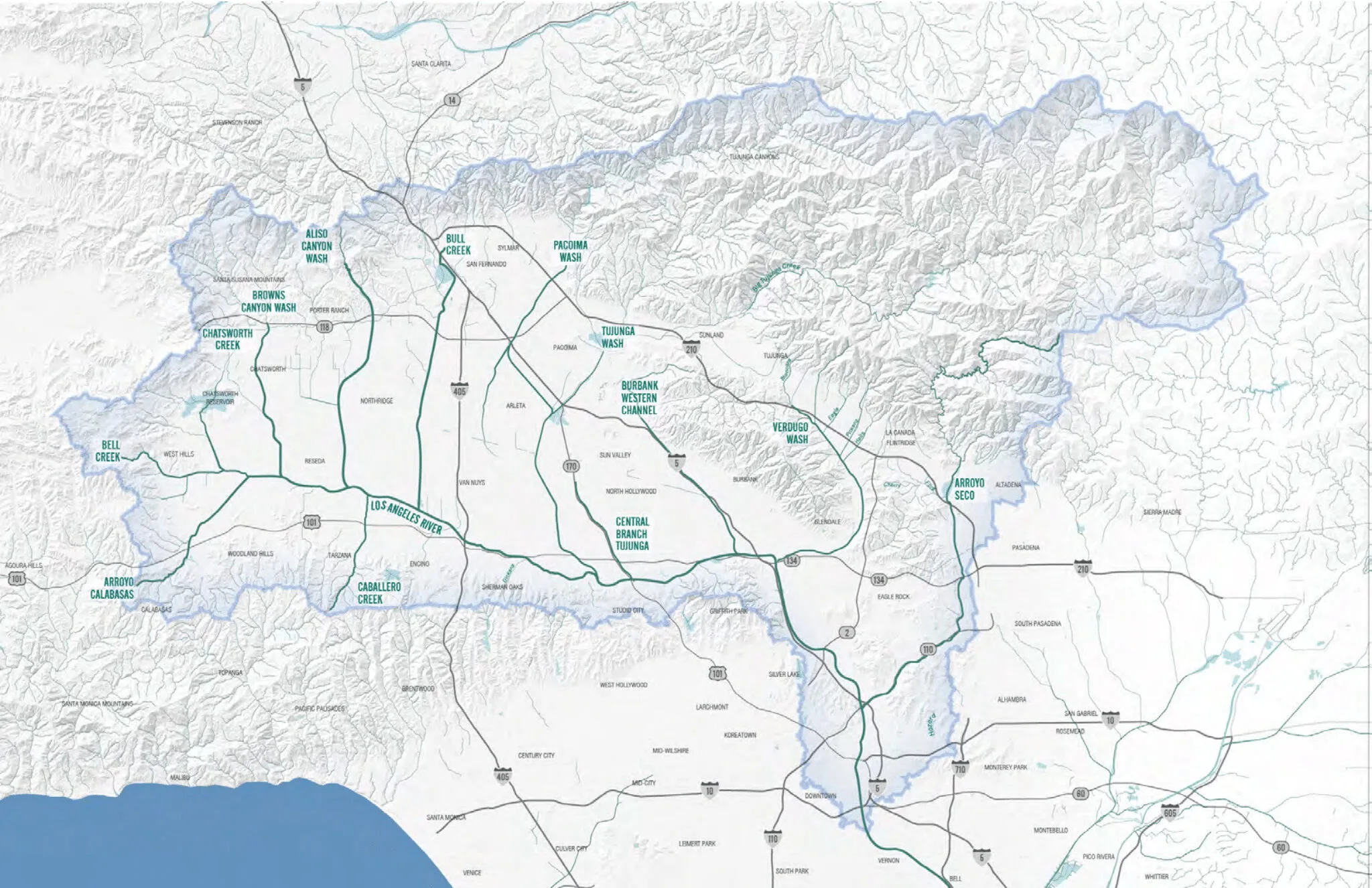
The ULART Working Group (formed by Assembly Bill 466 & Senate Bill 1126) developed this plan so low income communities with limited access to greenspace in the L.A. River Watershed have the opportunity to implement projects such as parks and paths along the river. The ULART Plan was developed to revitalize the L.A. River from Canoga Park to Vernon as well as Aliso Canyon Wash, Pacoima Wash, Tujunga Wash, Burbank Western Channel, Verdugo Wash, and the Arroyo Seco. This plan has identified areas along the L.A. River and its tributaries where multi-benefit projects will be implemented. This is the only plan discussed here that addresses tributaries, which have largely been ignored by revitalization efforts in the past.
As stated by the ULART Plan, the goals are to enhance the ecosystem; maintain and enhance flood management; increase opportunities for culture, arts, and recreation; and increase connectivity and green space along the river system. This plan has identified areas along the L.A. River and its tributaries where projects such as parks and bike paths can be designed and implemented. And, community members are encouraged to collaboratively develop project ideas and get them constructed. The plan was finalized and adopted in April 2020 and can be found on the ULART website.
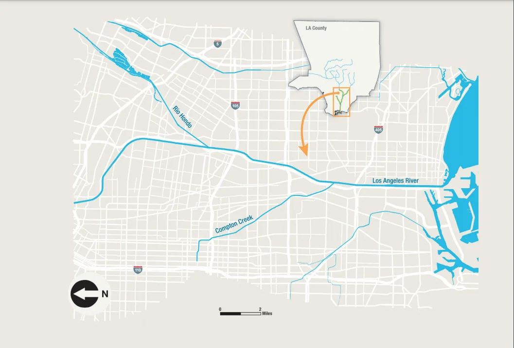
Lower L.A. River Revitalization Plan
The Lower L.A. River Revitalization Plan was set forth in Assembly Bill 530, and unlike the other plans discussed, has been in the implementation phase since 2018. This plan covers revitalization efforts in the lower 19 miles of the L.A. River from Vernon to Long Beach. Communities in this section of the river have lower than average incomes in L.A. County, are predominantly People of Color, and have been historically underserved by economic, educational, and environmental services. Local residents are disproportionately exposed to pollution and have little access to green space among other environmental injustices. Therefore, it is crucial the Lower L.A. River Revitalization Plan works to create benefits that will address systemic issues. As stated by the plan, the goals are:
Create diverse, vibrant public spaces along and connected to the Lower Los Angeles River resulting in safe, inviting, healthy green spaces that support diverse local communities, allowing equitable access to nature and a variety of recreation entertainment, multi-modal transportation and socio-economic opportunities that enhances quality of life and sustains watershed health.
Conserve and restore natural river and watershed functions while managing flood risk, enhancing the long-term ecosystem services provided to surrounding communities and mitigating climate changes and environmental impacts of urbanizing on the Lower L.A. River, floodplains, and associated habitats.
Heal the Bay was on the Working Group to help develop and offer feedback on the Plan and currently attends the Implementation Advisory Group meetings, where specific projects are brought forward for discussion and feedback in context of the Master Plan.
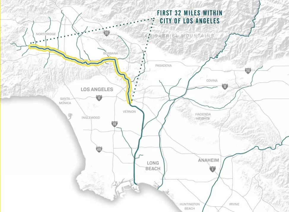
Los Angeles River Revitalization Master Plan (LARRMP)
This LARRMP was approved by the Los Angeles City Council in 2005, and it aims to revitalize the 32 miles of the L.A. River within L.A. City limits. The plan is intended to serve as a blueprint for transforming the river over the next 25-50 years, and the four “core principles” of the plan are as follows:
Revitalize the river by creating a continuous stretch of riparian habitat throughout the 32 mile section of the river in the city boundaries. The plan states that concrete removal will be considered as long as flood abatement ability of the river channel is not compromised.
Creating a continuous “River Greenway” that would consist of a network of bikeways, pedestrian paths, “green connections,” and open space.
Create a river that is safe, accessible, healthy, sustainable, and celebrated. The LARRMP states that it will address environmental justice issues by redeveloping polluted areas and providing natural spaces in neighborhoods that lack them.
Create value by encouraging participation and consensus-building, creating opportunities for sustainable, economic reinvestment, and adding value and providing an equitable distribution of opportunities to underserved neighborhoods along the River.
Projects under this plan are still ongoing, but some projects like Albion Riverside Park, have already been completed. Check the LARRMP website for updates.
Los Angeles River Ecosystem Restoration Feasibility Study
Adopted by the Los Angeles City Council in 2016, this proposed plan would transform 11 miles of the Elysian Valley in the Los Angeles River. The restoration would include the creation of riparian and marsh habitat, enhancing habitat connectivity to other natural areas such as the Santa Monica and San Gabriel Mountains. The plan will also include a natural hydrologic regime with the goal of restoring historic floodplains and connections to Los Angeles River tributaries. Ecological restoration under this plan will also allow for certain passive recreation opportunities like nature walks. There are some preliminary projects that must be completed before this plan is implemented, but the project is expected to be completed by 2029.
Los Angeles River Flows Project
Historically, the water in the L.A. River came from rainfall and groundwater upwelling in the Glendale Narrows. While that remains the case today, wastewater is now the dominant source of water in the main channel of the river during dry weather. The Tillman Water Reclamation Plant in Van Nuys and the Los Angeles-Glendale Water Reclamation Plant near Griffith Park both discharge treated wastewater into the L.A. River on a daily basis. Although this water originated from toilets, sinks, and drains, it is relatively free of contaminants like fecal matter.
In light of the recent long-term drought conditions in California and the looming threat of climate change, wastewater managers in L.A. are rethinking the practice of discharging treated wastewater into the L.A. River. That wastewater can be recycled, which would result in improved water resilience in times of drought and sustainable local water. However, the reduction of wastewater discharges into the river poses a potential problem for the river ecosystem that has come to rely on that water source. The State Water Board and other stakeholders have created the Los Angeles River Flows Project to evaluate the environmental and recreational impacts of reducing wastewater discharge into the L.A. River. The goal is to identify a water flow regime that will support a healthy river ecosystem, allow for recreation opportunities, and recycle enough water to be drought resilient.
Right now, the L.A. River Flows Project has been conducting analyses to identify the optimal flow regime, and research and meetings are planned to continue through the end of 2020. After that, a plan will be drafted and there will ideally be an opportunity for the public to weigh in on the plan.
Heal the Bay is a member of the Technical Advisory Committee as well as part of the Stakeholder Working Group. We will keep you updated on the progress of this and if there are opportunities for the public to voice their comments.
What’s with all these plans for the L.A. River?
Revitalizing the L.A. River is a monumental task so it makes sense to break the revitalization effort into different pieces. However, the main reason for this patchwork of plans is that they are all being led by different agencies. The LARMPU was created by L.A. County and ULART and the Lower L.A. River Revitalization Plan were created by legislation at the state level. The L.A. River Flow Plan was mandated by the State Water Resource Control Board. The LARRMP and L.A. River Ecosystem Restoration Feasibility Study are both overseen by the City of Los Angeles. Each plan states that it will work in conjunction with all the other plans; however, it is unclear what that collaboration will look like as three of the plans are not in the implementation phase yet.
What will these plans do exactly?
The L.A. River Master Plan, ULART, LARRMP, and Lower L.A. River Revitalization Plan will all identify areas along the L.A. River watershed where there is space for a project. A project can take the shape of many different things such as a park, retail space, housing, bike path, nature trail, and habitat among other things. The spaces where these projects will be placed are government owned or easily obtainable by a government agency. The Flows Project will not consist of any projects, instead, it will make recommendations on the amount of water in the river. This might change the habitat characteristics of the river as well as the recreational opportunities. We will know more as the plan continues to take shape. The L.A. River Revitalization Master Plan has already identified the locations of proposed projects.
How can I get involved?
When the L.A. River Master Plan is released to the public, you can provide comments about the changes you would like to see in the watershed. The Flows Plan has not been released yet, but the public will have the opportunity to comment when it is released. As plans are implemented, you will have the opportunity to weigh in on each individual project that gets implemented. We recommend tracking these projects on the L.A. River Master Plan, Lower L.A. River Master Plan, ULART Plan, LARRMP, and L.A. River Ecosystem Restoration Feasibility Study websites.
Los Angeles River Access and Points of Interest
Click on a trail segment, access point, or icon for photos and to learn more.
Winter rains in Los Angeles County flush an enormous amount of pollution into our storm drains from our streets, sidewalks, and neighborhoods. Where does this pollution end up? Who is responsible for monitoring and regulating it? And what’s next in the efforts to reduce it? Join Annelisa Moe, Water Quality Scientist at Heal the Bay, as she dives into the underworld of LA rain.
So, we know that stormwater is a huge source of pollution for LA’s rivers, lakes, and ocean. But have you ever wondered why? Or wondered how we track and manage this pollution? Well, let’s get into it…
In Los Angeles County, we have a storm drain system and a sewage system which are completely separate. The storm drain system is called the municipal separate storm sewer system (MS4). Separating these systems reduces the risk of sewage spills when storms might flood our sewage system, and attempts to get stormwater out of our streets before they flood. However, this separated system is also the reason why stormwater flows directly into our rivers, lakes, and ocean without being filtered or treated, leading to serious water quality issues throughout LA County that threaten public and environmental health.
Two main types of water flows through the storm drain system: (1) Stormwater, which is rainwater that cannot infiltrate into the ground naturally and instead builds up as it flows over the ground surface, and (2) dry weather runoff, which originates when it is not raining through activities such as overwatering lawns, or washing cars.
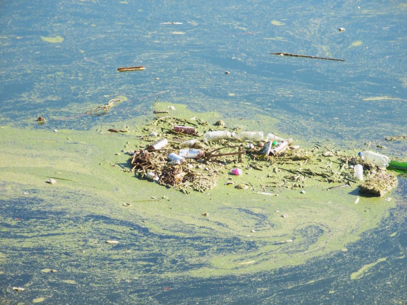
Water quality is much worse within 72 hours of a significant rain event in LA County. Last year alone, rain in our region accounted for almost 200 billion gallons of stormwater flushing through our storm drain system and into local bodies of water.
<
►
>
Under the Federal Clean Water Act, anyone who discharges water is required to limit the concentration of pollution in that water. This requirement is regulated under a permit to discharge water. The discharge of polluted stormwater and dry weather runoff through the storm drain system is regulated by the Los Angeles Regional Water Quality Control Board through an MS4 Permit. Cities and counties are permittees under an MS4 Permit, and are each responsible for their polluted stormwater and dry weather runoff.
The LA County MS4 Permit has been around since 1990, but in 2012 water quality had not improved much at all since then. The last update to the permit occurred in 2012, and, to our dismay, the Los Angeles Regional Water Quality Control Board unanimously voted to approve a 2012 MS4 Permit that was even worse than before – essentially setting up a scheme of self-regulation (meaning no regulation).
By no longer forcing cities that discharge millions of gallons of runoff into the storm drain system to adhere to strict numeric pollution limits, the Board took a giant step backward in protecting water quality throughout Southern California.
Under the 2012 rules, cities just had to submit a plan for reducing stormwater pollution (called a Watershed Management Plan) to the Board and have it approved to be in compliance, rather than having to actually demonstrate they are not exceeding specific thresholds for specific pollutants, such as copper or E. coli bacteria. These plans allow each permittee to choose the types of projects to build, and the timeline on which to build them. But these plans are adjusted each year, continuously drawing out implementation, and they do not include any clear way to determine if the permittee is making good progress.
We knew that this would slow progress even more, leaving stormwater pollution unchecked at the expense of public safety and aquatic health. Seven years later, we have the numbers to prove it.
In the next few weeks, Heal the Bay will be releasing a new report assessing the progress toward managing stormwater pollution in Los Angeles County, and how we can fix the permit when it is renewed in early 2020.
In the meantime, we encourage you to safely document photos and videos of trashed waterways and beaches, clogged storm drains, and stormwater pollution in LA County after it rains. Remember, safety first! Proceed with caution, observe all posted signs, and watch out for heavy flowing water. If you do snag a good image, please tag your location, #LArain, @healthebay and #healthebay. You can also tag relevant government officials to help raise awareness.
Our team at Frogspot in Elysian Valley. The LA River’s soft, mud-bottom sections are capable of supporting vegetation and wildlife.
In the summer of 2019, Heal the Bay’s team of water quality monitors spent many sunny days gathering freshwater samples from Malibu Creek State Park and the LA River, and testing them for bacterial-pollution in the lab. (Dive deeper into the findings.)
We’re thankful to partner with Los Angeles Trade Technical College (LATTC) who allowed us to work out of one of their labs, managed by Manuel Robles. As always, our team included local students eager to learn about water quality and public health. Along with sampling, this group also took part in outreach, educating and encouraging more people to be invested in improving the health of the LA River Watershed.
Read on for some of our team’s favorite highlights from the summer
Erik Solis
My favorite part about the summer program was not only the job itself, but the outreach to younger students who show interest in environmental science. I was able to tell them about what I do for Heal the Bay, why it matters, and how they can contribute themselves. It all comes together to make a positive impact in the community and encourage young minds to promote a cleaner L.A. watershed. I enjoyed the work I’ve done this summer, as I know I have done a huge service to the L.A. river area. I can recall this one time a couple of fishermen and women said, “Hey, the Bay healers are here!” Another favorite part was participating in the Coastal Cleanup day on September 21st, as not only was I able to meet a lot of people, talk to students, and clean up a river, but I was also able to bring my family out to participate and enjoy doing their part in doing a service to the Greater Los Angeles Area. I have also enjoyed the lab work, but it was a little overshadowed by the field work.
Stephanie Alvarez
As someone who grew in Los Angeles I wasn’t as aware of how much nature we still have in the city, and I want to help protect it and the people who want to enjoy it. My most favorite memory was when a few of us got to speak to high school students and saw how most of them grasped the urgency of keeping our water clean. They all had their own unique ideas and all agreed that keeping our waters clean was very important. This gave me even more hope that we will be able to save our bodies of water. As someone who wants to help find ways to clean water, in an effective and cheap manner, this experience helped me see the problem in different angles. I went into this program thinking only of how to clean water to drink it, and now I am thinking about how we can make it clean enough for people to swim in and wildlife to thrive in. This program helped me gain experience in the lab and helped me dream bigger. We were so lucky to have worked alongside many amazing people, and I wanted to thank Luke for being an amazing leader! I suggest, if you are reading this and you want to help your planet, to get involved. There are so many programs and events that you can sign up for free. Change always starts with one person! Together we can save our planet and our wildlife!
Blaire Edwards
I started off by trying something different and left with an abundance of information about the environment around me. My favorite part of this experience had to be learning about all the matters happening environmentally and what I can do to get more involved and help make a difference.
Christina Huggins
With so many adventurers heading outdoors to enjoy the summer weather, the highlight of sampling water quality for Heal the Bay this summer was the opportunity to connect with the community and educate them about their environment. From early morning hikes through the Santa Monica Mountains to curious explorers and hikers asking questions about our yellow boots and sample bottles. Getting the opportunity to be a part of keeping the public informed about freshwater quality has given me a new direction in my career and educational path.
Michelle Allen
The biggest highlight of working on the team this summer is knowing that what we do and the information we collect makes it to the general public. The fact that our samples that we test affect people’s choices to make safer decisions, is a huge part of why I love being a part of this team. Collecting samples is always something fun to me. I love the fact that we go out into nature and see how the land changes each time we go out while meeting people along the way.
Olivia Garcia
My favorite part of the summer was collecting water samples for analysis. I liked being able to see, understand, and make note of the factors that could potentially contaminate the water quality in the river. I was also fascinated with the quality control protocol. I gained a lot of knowledge about the importance of consistency in documentation and testing, and a better intuitive understanding of quality control as a whole. It’s hard to pick out what the overall highlight of the summer was because it was all so amazing.
<
►
>
Christina and Michelle collecting samples from the popular Rock Pool in Malibu Creek State Park.
Blaire, Olivia, and Luke collecting storm drain samples along the Elysian Valley.
Luke Ginger, Water Quality Scientist at Heal the Bay, recounts the latest season of freshwater monitoring, reveals the disappointingly poor water quality grades, and explains what this means for public health and the future of the LA River.
The summer of 2019 marked Heal the Bay’s sixth summer sampling in Malibu Creek State Park and the fifth summer sampling in the LA River freshwater recreation areas. Currently, there is no federal or state mandate or funding for monitoring freshwater recreation areas as there is for ocean beaches. So local freshwater stakeholders monitor water quality in LA County with their own funds. Heal the Bay samples in various places to fill in some of the sampling gaps left by those organizations.
This season, we regularly monitored the Rock Pool and Las Virgenes Creek in Malibu Creek State Park, the LA River at Burbank Boulevard, and three sites in the LA River near Elysian Valley. We also sample the storm drains along the Elysian Valley to help us understand the origin and amount of bacteria entering the LA River. In total, our team collected 96 river and stream samples, and about 84 storm drain samples.
Disappointing Findings, Yet Encouraging Outreach
Grades in the LA River recreation zones were disappointingly poor this summer. The four sites we tested had good water quality (green grades) just 16% of the time on average. That means bacteria levels exceeded at least one standard (yellow or red grades) 84% of the time in the LA River. Malibu Creek State Park sites had similar water quality where green grades were issued 19% and bacteria exceeded standards 81% of the time. For the public, this means that water quality presents indicates a risk for human illness more than 80% of the time.
In addition to protecting public health by reporting freshwater quality grades, our mission is to conduct outreach and get more people invested in improving the health of the LA River Watershed. This summer was jam-packed with events that allowed us to spread our message and make an impact. We tabled at events along the LA River, participated in river cleanups (including the first-ever Trash Blitz at Compton Creek) and also collaborated with Pacoima Beautiful, FOLAR and CSUN to educate high school students on water quality in the river. This fall, we are continuing our student outreach by giving lectures at local high schools and providing students hands-on experience collecting water samples.
<
►
>
We tabled at the Wiltern for an Ice on Fire documentary event. We even got to take over the Wiltern’s Instagram account for the day!
Looking Forward
Protecting the public from potentially harmful water has been Heal the Bay’s mission for the past 30 years with the Beach Report Card, so our next step has been to provide the same water quality information for freshwater recreation areas. Because a healthy Bay starts with a healthy LA. To dive deeper into our freshwater work, check out our River Report Card. And stay tuned for the next release in Spring 2020, which will include a full assessment of these recent water quality grades.
We are also anxiously waiting for the release of the LA River Master Plan in December 2019, which is LA County Department of Public Works’ plan to revitalize parts of the river. We are eager to see an LA River that supports both nature and the surrounding communities without displacing them, so we urge everyone to follow the LA River Master Plan updates and get involved.
Our monitoring program also got some attention in the media!
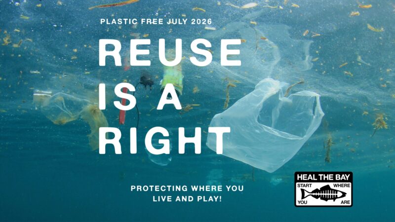
Less than 10% of all plastic ever produced has been recycled.
This Plastic-Free July, Reuse Is a Right. Learn why expanding reusable systems is key to reducing plastic pollution, then take action by signing our petition urging LA leaders to support a reusable future for Los Angeles.