Top

Heal the Bay Blog

Category: Beach Report Card Spanish

Ocean lovers in the Orange County now have a newly-enhanced resource for assessing water quality conditions before going for a swim.

 The Orange County Health Agency’s Ocean Water Protection Program just upgraded its public web tool, making it more user-friendly with features that include:

  • An interactive Google Earth map on the homepage that allows a quick status check of current ocean water quality conditions.
  • Color-coded map pins (green-yellow-red) indicating the current ocean water quality conditions.
  • A “menu bar” along the top of the Google Earth map that provides an easy-to-use drop down list to find your favorite local beach area, from Huntington Beach to San Clemente.
  • Clicking on the drop down list provides a close up view of the local beach area with water quality status, current weather conditions, beach amenities and beach information links.
  • Clicking on a color-coded pin provides a photo and directions to the beach along with information about the monitoring location and its sampling frequency.

Give it a try!

Read how California beaches fared in Heal the Bay’s recently-released annual Beach Report Card® . Weekly grades are also available from your iPhone or Android or online at www.beachreportcard.org. In addition, grades can now be viewed on Weather Underground.


California beachgoers can head to the shore with little anxiety this summer, as their beaches are generally very clean, according to Heal the Bay’s 2012 Beach Report Card®. In fact, 407 of the 441 beaches monitored throughout California’s summer dry weather received very good to excellent (A and B) grades; a 2% improvement from the previous report.

The Report

Press Releases

Online Beach Report Card

This is the 22nd time Heal the Bay has released an annual Beach Report Card, which provides water quality information to millions of people who swim, surf, dive or fish along the West Coast, including Oregon and Washington.

This year’s grades encompass more than 650 locations along the West Coast for summer dry weather and more than 300 locations year-round on an A-to-F scale. The grades represent the risk of adverse health effects from bacterial pollution.

Overall, only 25 of the beaches (6%) monitored statewide received D or F grades during summer dry weather, when most beachgoers typically use the ocean. High bacteria counts at these sites are linked to such potential illnesses as stomach flu, ear infections and major skin rashes.

Los Angeles County once again leads Heal the Bay’s annual Beach Bummer List, with seven locations in the ranking of the state’s 10 most polluted beaches. Avalon Beach on Southern California’s Catalina Island, troubled by outdated and leaking sewers, claimed the No. 1 spot.

On the positive side, San Diego, Orange and Ventura counties once again had superb water quality in dry summer. Central and Northern California ocean beaches also continued their trend of outstanding water quality in dry weather, save for some troubled spots in Santa Cruz and San Mateo counties.

Read the full report.

Beachgoers can check Heal the Bay’s Beach Report Card weekly grades from their iPhone or Android, or online at www.beachreportcard.org. In addition, grades are now available on Weather Underground.


At a hearing today, Judge James Chalfant upheld L.A. County’s plastic bag ordinance.

The Court found that the County’s proposed 10-cent paper bag charge was not a tax under the California Constitution because retailers keep all of the money collected pursuant to the ordinance, and even if the charge were a tax, it would be considered exempt to Prop 26.

While an appeal is expected, this decision is encouraging for California cities moving forward with their own plastic bag ordinances.

Read more.


A 12,000 gallon sewage spill on Saturday, Feb. 11 in Compton flowed into the Los Angeles River. City of Long Beach officials ordered all open coastal beaches closed.

According to the Long Beach Post, this spill–attributed to a blocked sewer line–is similar to the Studio City spill of last year and Burbank spill in 2010, each effectively shutting down the coastal areas of Long Beach.

The Los Angeles River ends in Long Beach, where beaches will remain closed until the Long Beach Health Department testing indicates the water is safe to swimmers.  

For the latest status on Long Beach recreational beach water quality, call the Water Hotline at 562.570.4199.

For up-to-date beach closure information, download the free mobile app for iPhone and Android, or visit the Beach Report Card.

Follow the Beach Report Card on Twitter.


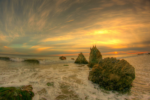
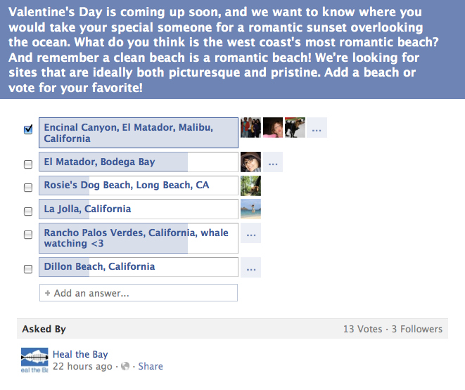
The “Ocean Lover’s Choice,” El Matador, won our Facebook poll, which asked supporters to share their favorite romantic beach along the West Coast. You can’t get much more dramatic than this secluded rocky cove.

Discover the other top 10 most romantic beaches in our Valentine’s Day Beach Guide for Ocean Lovers.

Encinal Canyon, El Matador State Beach in Malibu, a Flickr photoset by “Mulling it Over”


As top vacation destinations in the country, beaches are critical for recreation and the U.S. economy.  Specifically, California’s coastal tourism, which generates substantial revenues, is largely dependent on clean waters. Yet, every year, millions of people become sick after visiting America’s beaches. This can ruin not only your vacation, but can lead to lost work and productivity.

A new EPA proposal to address pollution at U.S. beaches contains the startling conclusion that EPA thinks it is acceptable for 1 in 28 people to get sick when they go to the beach!  Children are especially vulnerable, perhaps because they tend to submerge their heads more often and are more likely to swallow water when swimming. Imagine a school field trip to the beach – for every large conventional school bus, nearly three kids are put at risk of getting an illness like diarrhea, nausea, or vomiting.

EPA’s proposal also allows water testing to be averaged over a period as long as 90 days and for one in every four samples to exceed safe levels before pollution reduction is required. Both of these approaches could mask a serious pollution problem and expose families to an unnecessary risk of illness. Families shouldn’t be exposed to high levels of bacteria—and have increased chances of getting sick—just because the levels of contamination are lower on one day than on another. Beachgoers don’t need loopholes like this in the safety standards that are supposed to protect us. 

Please tell EPA to make sure America’s beaches are safe for all beachgoers, especially children. 


Show the special ocean lover in your life what they mean to you by donating a gift to Heal the Bay this Valentine’s Day. At the same time, you’ll be making a significant difference to our local waters.

If you like, Heal the Bay will send notification of your dedication gift along with your personal note to the person of your choosing.

Dedicate a gift.


Last chance to cast your vote! Get your vote in today!

El Matador Beach Photo by Barry M. VS. Ranchos Palos Verdes Photo by Eric Magnuson

With Valentine’s Day approaching, we want to know the ideal coastal spot for sparking a romantic mood. It can be anywhere along the U.S. West Coast, from California to Oregon and Washington.  El Matador and Ranchos Palos Verdes have garnered top votes, which one will claim the top spot? 

Cast your vote! 

Facebook Question: Most Romantic Beaches for Valentine's Day