Top

Heal the Bay Blog

Category: Marina del Rey / Playa del Rey

Heal the Bay’s 21st Annual Beach Report Card® provides water quality information to the millions of people who swim, surf or dive in California, Oregon and Washington coastal waters. This is the first annual report to cover the entire West Coast, with the debut of beach water quality grades from our northern neighbors, Oregon and Washington.

Button - View Full Report

Report Snapshots  

Just the Grades

Press Releases by Region

Documents in Spanish

Contacts at Heal the Bay

The 2011 Annual Beach Report Card incorporates more than 150 additional monitoring locations along the coasts of Washington and Oregon. Essential reading for ocean users, the report card grades approximately 600 locations along the West Coast for summer dry weather and more than 324 locations year-round on an A-to-F scale based on the risk of adverse health effects to beachgoers. The grades are based on fecal bacteria pollution concentrations in the surf zone. The program has evolved from an annual review of beaches in the Santa Monica Bay to weekly updates of beach monitoring locations throughout California, Oregon and Washington. All of this information is available on this website, www.healthebay.org, and the online Beach Report Card microsite at www.beachreportcard.org.

Recreating in waters with increased bacteria concentrations has been associated with increased risks to human health, such as stomach flu, nausea, skin rashes, eye infections and respiratory illness. Beach water quality monitoring agencies collect and analyze samples, then post the necessary health warnings to protect public health. Poor water quality not only directly threatens the health of swimmers and beachgoers, but is also directly linked to ocean-dependent economies.

Ocean water quality monitoring is vital to ensuring the health protection of the millions who recreate in coastal waters. Since the Annual Beach Report Card was first published more than twenty years ago, beachgoers throughout California have come to rely on the grades as vital public health protection tools. Now, residents and visitors of Oregon and Washington beaches will have the same critical information at their fingertips.

West Coast Beach Water Quality Overview

Most California beaches had very good to excellent water quality this past year, with 400 of 445 (90%) locations receiving very good to excellent (A and B) grades during the summer dry time period (California’s AB411 mandated monitoring from April to October). Year-round dry weather grades were also very good, with 284 of 324 (88%) locations earning A or B grades. Lower grades during year-round dry weather included 12 Cs (4%), 12 Ds (4%) and 16 Fs (5%).

Southern California (Santa Barbara through San Diego counties) summer dry (AB411) weather grades (91% A and B grades) were actually slightly better than the state average. In the San Francisco Bay Area (Marin through San Mateo counties), the summer dry weather ocean-side grades were excellent with 95% (40 of 42) of locations receiving an A or B grade. The bay-side’s water quality slipped slightly with 73% (19 of 26) A or B grades compared to 81% (21 of 26) last year. 60% (41 of 68) of these Bay Area locations were monitored frequently enough to earn year-round grades. Year-round dry weather water quality on the ocean-side was good, with 90% (18 of 20) of the monitoring locations receiving an A or B grade. It was fair on the bay-side with 67% (14 of 21) locations receiving A or B grades.

The disparity between dry and wet weather water quality continues to be dramatic, thereby demonstrating that California is not successfully reducing stormwater runoff pollution. This year’s (April 2010 – March 2011) report shows 46% of the 324 statewide locations monitored during wet weather received fair to poor (C–F) grades. In Southern California, 50% of sampling locations earned fair to poor wet weather grades. Despite higher than normal precipitation levels this past year, wet weather grades were slightly better than the seven-year average (years since new methodology implementation) for both Southern California and statewide.

While 60 locations were monitored throughout the summer in Oregon, only 13 were monitored frequently enough (at least weekly) to be considered for this report. All of Oregon’s 13 regularly monitored locations received A grades. Washington monitoring locations were also typically clean, with 93% of the 141 monitored receiving A and B grades.

California’s Dry Weather Honor Roll

Sixty-eight of the 324 beaches (21%) with year-round dry weather grades this year scored a perfect A+. These beaches had zero exceedances of state bacterial standards for ocean water quality during dry weather throughout the entire time frame of this report. These beaches demonstrated that superb water quality can be found in areas impacted by wildlife, but without anthropogenic sources of fecal bacteria. Heal the Bay proudly places these beaches on the 2010-2011 Beach Report Card Honor Roll. (A list of these locations can be found in the full report, Appendix B on Page 78.)

California Beach Bummers

Numerous California beaches vied for the Beach Bummer crown this year (the monitoring location with the poorest dry weather water quality). Four of the 10 most polluted beaches in the state were in Los Angeles County. Though most of these beaches are no strangers to the Beach Bummer list, Topanga State Beach made its first appearance since 2005-2006

Top 10 Beach Bummers (each location links to the online Beach Report Card)

  1. Cowell Beach – at the wharf (Santa Cruz County)
  2. Avalon Harbor Beach – Catalina Island (L.A. County)
  3. Cabrillo Beach – harborside (Los Angeles County)
  4. Topanga State Beach – at creek mouth (L.A. County)
  5. Poche Beach (Orange County)
  6. North Beach/Doheny (Orange County)
  7. Arroyo Burro Beach (Santa Barbara County)
  8. Baker Beach – at Lobos Creek (San Francisco County)
  9. Colorado Lagoon (Los Angeles County)
  10. Capitola Beach – west of the jetty (Santa Cruz County)

The data from Santa Barbara County through San Diego County was analyzed to determine whether there were significant differences in water quality based on beach type. As in previous years, water quality at open ocean beaches during year-round dry weather was significantly better than water quality at those beaches located within enclosed bays or harbors, or those impacted by storm drains. 99% of open ocean beaches received an A grade for year-round dry weather compared to 76% at beaches found within an enclosed bay, harbor or marina, and 76% at beaches impacted by a storm drain. The data demonstrate that visitors at open ocean beaches with no pollution source are nearly always swimming in clean water during dry weather.

Funding California’s Beach Monitoring Program

Monitoring efforts have been at risk statewide since then-Governor Arnold Schwarzenegger’s 2008 lineitem veto of nearly $1 million in California beach monitoring funds. Fortunately, some municipalities have temporarily allocated additional local funding in order to provide this invaluable service to the beachgoing public. The State Water Resources Control Board (SWRCB) directed Proposition 13 Clean Beach Initiative (CBI) grant funds to backfill the beach monitoring funds from July 1, 2008 through June 30, 2010. In addition, federal American Recovery and Reinstatement Act (ARRA) stimulus funds were approved to cover the monitoring season through 2010. On Nov. 2, 2010, the SWRCB approved a resolution to commit $984,000 from available funds, Proposition 13 or 50, to continue the state’s beach monitoring program through the end of 2011. The SWRCB has been working with members of the Beach Water Quality Group in order to explore options for sustainable, long-term funding; as the state cannot afford to fund any of the beach monitoring program after 2011.

There is no secured state source of funding for beach monitoring in 2012 and current federal Beaches Environmental Assessment and Coastal Health (BEACH) Act funding to California (about $500,000) is woefully inadequate. A protective beach monitoring program would cost about $2 million a year for conventional analytical methods, and approximately $3 million a year if rapid methods are used at California’s most polluted beaches. Heal the Bay will continue working with the state and local governments throughout California to ensure that future funding is secured.

Although beach water quality monitoring funding has seen cutbacks before (state funding was reduced by 10% in 2007), the complete elimination of state funding in 2008 by Gov. Schwarzenegger sent a message from Sacramento to the oceangoing public that its health is not a priority. It is imperative that government officials, county and state health departments, and non-governmental organizations (NGOs) strive towards a long term solution that will permanently restore funding to counties’ beach and bay water quality monitoring programs.

We have seen a marked and steady decline in the number of beaches monitored throughout California as a direct result of this funding uncertainty. Seventy-two beaches were not monitored during the summer dry (AB411) period and 47 were not monitored year-round compared to before 2008. This is equivalent to 2,770 fewer samples taken year-round compared to before 2008. Continued efforts must be made to ensure that adequate and sustainable funding becomes available for beach water quality monitoring immediately.

General Observations

Children play directly in front of storm drains and in runoff-filled ponds and lagoons. Monitoring at ‘point-zero’ (the mouth of storm drains or creeks) is the best way to ensure that the health risks to swimmers are minimized.

This is one recommendation among several that Heal the Bay has made to state officials to improve water quality monitoring and better protect public health. (A complete list of recommendations can be found at the end of the full report, page 68.)

The Beach Report Card is based on the routine monitoring of beaches conducted by local health agencies and dischargers. Water samples are analyzed for bacteria that indicate pollution from numerous sources, including fecal waste. The better the grade a beach receives, the lower the risk of illness to ocean users. The report is not designed to measure the amount of trash or toxins found at beaches. The Beach Report Card would not be possible without the cooperation of all of the shoreline monitoring agencies in California, Oregon and Washington.

Heal the Bay believes that the public has the right to know the water quality at their favorite beaches and is proud to provide West Coast residents and visitors with this information in an easy-to-understand format. We hope that beachgoers will use this information to make the decisions necessary to protect their health.

Health officials and Heal the Bay recommend that beach users never swim within 100 yards on either side of a flowing storm drain, in any coastal waters during a rainstorm, and for at least three days after a storm has ended. Storm drain runoff is the greatest source of pollution to local beaches, flowing untreated to the coast and often contaminated with motor oil, animal waste, pesticides, yard waste and trash. After a rain, indicator bacteria densities often far exceed state health criteria for recreational water use.

Sponsors

A special thank you to to the following for their continued support in funding the
Beach Report Card program and the publication of the 2010-2011 annual report:

The Diller – von Furstenberg Family Foundation logo

simplehuman logo

LAcarGuy logo

SIMA logo

Grousbeck Family Foundation


Attorney and Heal the Bay board member Dayna Bochco is expected to serve a four-year term with the Calfornia Coastal Commission. Bochco also sits on the City of Los Angeles’ Measure O Citizen Oversight Committee. Her leadership has been instrumental in establishing marine protected areas in Southern California, abating stormwater pollution in Los Angeles and tackling the global marine debris crisis. She is set to replace fellow environmental champion, Sara Wan. Congrats Dayna.

Press Release


Recently, the first tsunami related debris arrived on the West Coast, in Washington State.

Heal the Bay plans to continue our monthly beach clean-up activities, and will be scouting for any potential tsunami related debris. We will do our best to report any tsunami related debris to those that are tracking it. As of now, we do not plan to do any monitoring for radioactivity. Monitoring was conducted in the debris field at sea in September 2011, and the results showed no radioactivity. The debris was washed out before radioactive water started leaking from the power plant, so the contamination route is unlikely.

Do you have some questions about how the Japan tsunami debris may affect the California coast? The National Oceanic and Atmospheric Administration (NOAA) has the answers.

Whether you have concerns regarding radioactivity or need more information about what the navigational safety hazards will be, for the latest updates, check out NOAA’s marine debris site.

If you find any on your beaches, you can report it to MDsightings@gmail.com

Photo: yisris via Flickr


Earlier in the week, Frankie Orrala and James Alamillo gave a staff presentation in our office on the progress of the Pier Angler Outreach Program coordinated by Heal the Bay, EPA and the Fish Contamination Education Collaborative (FCEC).  Frankie and James have run Heal the Bay’s program for eight years.  Their achievements, along with the efforts of the outreach workers, have been nothing short of astounding.

To date, the program has educated nearly 100,000 anglers at eight different piers: Santa Monica, Venice, Hermosa, Redondo, Pier J, Rainbow Harbor, Belmont and Seal Beach piers. (Cabrillo Marine Aquarium educates Cabrillo Pier anglers).  The risk communication efforts focus on the health risks of eating locally caught DDT-, PCB- and mercury-contaminated fish.  The outreach workers encourage anglers to avoid the most compromised fish, and they provide fishermen with cooking methods if they choose to eat any contaminated catch.

Read more & comment» (new window)


Strandings of marine animals in Southern California have increased dramatically in the past few weeks. The mortality rate is up and rescue teams and care centers are overrun with a large number of ailing sea lions and birds. We asked David Caron, a professor in USC’s department of Biological Studies, if he could explain what is causing these animals’ illness and death.  He responded with the following:

Domoic acid is a powerful neurotoxin produced by a specific group of microscopic algae that sometimes blooms in coastal waters.   If the algae are abundant and producing toxin, they can be strained from the water by plankton-eating fish such as sardine and anchovy.  The toxin contained in the algae is concentrated in the stomachs of these fish during a toxic algal bloom.  Marine mammals or sea birds eating fish laden with toxin can ingest sufficient domoic acid in the stomachs of their prey to experience symptoms of domoic acid poisoning.  These symptoms can include a variety of neurological disorders including disorientation and seizures, and in severe cases death.

There has been an increased number of animals (sea lions, dolphins and some birds) stranding on local beaches during the past few weeks.  Many of these animals exhibited symptoms of domoic acid poisoning.  We have confirmed the presence of domoic acid in fluids collected from a number of these animals, indicating that a toxic bloom is taking place in coastal waters, although the specific location and extent of the bloom is not known.

Hear a more detailed interview with Professor Caron on National Public Radio station KPCC.


Understanding U.S. Fisheries Management

Part 1 of a 2 part series from National Geographic’s News Watch.  Photo by Captain Tom Migdalski


The United States has the largest Exclusive Economic Zone (EEZ) in the world, containing 3.4 million square miles [8.8 million square kilometers] of ocean and 90,000 miles [145,000 kilometers] of coastline.[i] Throughout this vast underwater realm, fish play an essential role in the interconnected web of life on which we depend. In fact, they are one of America’s most valuable natural resources, adding billions to the U.S. economy and supporting millions of jobs through fishing and recreation.

Unfortunately, overfishing—taking fish from our oceans faster than they can reproduce—has plagued U.S. oceans for decades and continues today. This squanders valuable fish populations and weakens ocean ecosystems, making them more vulnerable to problems like pollution, natural disturbances and climate change.

The good news is that we have a strong law in place in the United States governing how fish are managed in federal waters, and serious efforts are underway to end overfishing and rebuild depleted populations

Read more.

The U.S. is an ocean nation. Its exclusive economic zone (EEZ), extending 200 miles offshore, is larger than the combined land area of all 50 states--the largest in the world. The EEZ encompasses diverse ecosystems and vast natural resources, such as energy and mineral resources--and fisheries. (Courtesy: NOAA Fisheries Service).


Heal the Bay is joining the fight to protect sharks this Earth Month by promoting legislation that would outlaw the sale of shark fins. Sign now!

Every year, fins from tens of millions of sharks are used for shark fin soup. The human appetite for shark fins is a major contributor to the near collapse of shark populations worldwide, including in California. One of the most effective ways to protect sharks is to eliminate the market for fins by prohibiting their sale. AB 376, a bill being considered in the California state legislature, will ensure stronger protections for sharks by banning the possession, sale, trade and distribution of shark fins. Hawaii and the Commonwealth of Northern Mariana Islands have recently passed similar legislation, and Guam, Oregon, and Washington state legislatures are also considering similar bans.
 
The ruthless practice of shark finning (which leaves live animals finless and unable to swim) remains legal in many parts of the world. It is dangerously efficient because it enables fishing crews to throw out low-value, unmarketable shark carcasses and retain only the fins. As predators at or near the top of marine food webs, sharks help maintain the balance of marine life in our oceans. Research shows that the massive depletion of sharks has cascading effects throughout the oceans’ ecosystems. AB 376 will give critical protection to sharks and preserve the health of our oceans.
 
California represents a significant market for shark fins in the United States, and this demand helps drive the practice of shark finning and declining shark populations. San Diego and Los Angeles are two of the top U.S. entry points for shark fin imports. Most fins are processed in Asia and exported around the world, and fins sold in California may come from these markets.
 
Although shark fin soup has long been a popular entrée because of its association with prestige and privilege, concerned individuals across Asia – including China, Taiwan, Singapore and Hong Kong – have formed shark protection groups to highlight the plight of sharks. Some governments and businesses in the Pacific region have pledged to not serve shark fin soup at government functions, business meetings and celebratory banquets. Likewise, a growing number of globally recognized Asian chefs support alternatives to shark fin. We recognize the cultural importance of shark fin soup as a ceremonial dish, and the sacrifice that the Chinese community in California will be making to give it up in their support of ocean health. This leadership is also reflected by the group of respected Asian Pacific American leaders, elected officials, celebrities and advocates that have joined in support for AB 376.
 
Look out for petitions during Earth Month at Heal the Bay booths at festivals and fairs, or get more information when you stop by our Santa Monica Pier Aquarium during public hours, or at the Victor Douieb Shark Sculptures Premiere.

ACT NOW: Sign the petition to end shark fin sales in California.

Photo: USFWS Pacific via Flicker


Heal the Bay is looking for people to join our Angler Outreach Team! This group of dedicated people spends their days on local piers talking to fishermen about the importance of avoiding contaminated fish. The national EPA recently awarded the program one of its top honors for protecting public health.

In Santa Monica Bay, most fish are safe to eat. Some species, however, are contaminated with DDT, PCB and mercury dating from the decades old hot spot off the coast of Palos Verdes. This is particularly true for white croaker (also called Kingfish or Tomcod), barred sand bass, black croaker, topsmelt and barracuda.

If you’re interested in joining the Angler Outreach program, please visit our jobs page. Or learn more about the DDT contamination off the coast of PV.


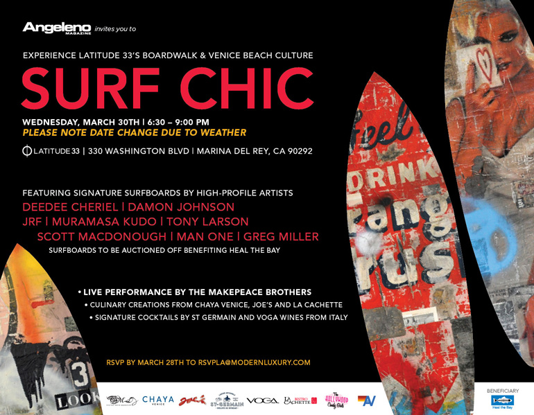
Latitude 33 and Angeleno Magazine to Host Surfer Chic Fundraiser Featuring Auction of Artist Made Surfboards and Musical Performers The Makepeace Brothers on March 30th in Venice Beach

Large portion of surfboard auction proceeds to benefit Heal the Bay

LOS ANGELES, CA (March 16, 2011) — Latitude 33, the 122-unit modern beach-inspired community located at 330 Washington Blvd. in Marina del Rey, Calif., and Angeleno magazine have announced a March 30th fundraiser event to be held in conjunction with Heal the Bay. In homage of the local vibrant art and music experience of the Venice Beach boardwalk, the event will feature an auction of unique one-of-a-kind surfboards handmade by eight well-known artists as well as a live acoustic musical performance by local roots rock favorite The Makepeace Brothers. The event auction proceeds will benefit Heal the Bay and its efforts to keep our coastlines and waterways clean.

The RSVP-only March 30th fundraiser will be held from 6:30 pm to 9:00 pm onsite at Latitude 33 in the BOARDWALK Collection, one of the beach chic community’s three eclectic living options offering lushly landscaped outdoor living spaces and a mix of contemporary floorplans. Upon arriving, guests will be greeted and directed toward the artistic display of surfboards created by artists Damon Johnson, Greg Miller, Muramasa Kudo, Tony Larson, Deedee Cheriel, Man One, Scott MacDonough and JRF. Once viewed, guests will bid on these eight custom designed surfboards that evening from 6:30 pm to 8: 45 pm in an auction curated in conjunction with Culture Shock Marketing (CSM) with proceeds benefiting Heal the Bay. All bidders at the live event must be present to claim their surfboards.

During the week prior to the March 30th event, one special surfboard will be placed for auction online at www.CharityBuzz.com. Participants will be able to place bids on the board from March 15 through March 30. Bidding will start at $1,000 and increase in $250 increments until the board is sold.

As part of the contemporary beach experience, The Makepeace Brothers, a local roots rock favorite known for their exceptional acoustic style, will entertain guests at the event with a live performance. Culinary favorites will be served by local artisanal eateries Chaya, La Cachette and Joes. Guests will also experience an assortment of beach-inspired cocktails provided by St. Germain, a shaved ice display and a selection of wine from sponsor Voga Italia Wines.

Favorite local lifestyle retailers Linus Bikes and Aviator Nation will also play important roles in the March 30th fundraiser. Linus Bikes, purveyor of the French inspired utilitarian city bike, will auction off a bike. Aviator Nation, the vintage t-shirt line, will conduct informal modeling of their unique clothing pieces and will furnish the closets in the BOARDWALK model unit.

For event details and to RSVP, see our calendar listing.

SURF CHIC Invitation


Finescale Triggerfish

The Finescale Triggerfish (Balistes polylepis) is the latest resident of the Santa Monica Pier Aquarium’s Beneath the Pier exhibit. Triggerfish are usually associated with tropical water, but their range stretches from San Francisco all the way to Peru. This fish has a feisty reputation and reportedly has been seen attacking sharks. Our triggerfish was shy at first, but has lately been seen coming right up to the glass, seemingly to check out our visitors and making it hard to tell who is observing whom.

Fun Facts

Triggerfish are often found in caves and crevices, but are also seen swimming in the open along the sandy bottom adjacent to rocky reefs and in waters as shallow as 10 feet. With powerful jaws and a set of eight teeth on each jaw, this fish is equipped to eat spiny sea urchins, small crustaceans, mollusks and other animals that are normally protected by a shell or armor.

The finescale triggerfish can reach a length of up 30 inches and usually weighs up to 10 pounds. The largest reported specimen was 16 pounds. Fossils of finescale triggerfish teeth dated at 25 million years old have been found in Santa Ana and Bakersfield.

Some triggerfish are toxic if eaten, but the finescale triggerfish has never been found to be toxic. Still the finescale doesn’t show up on the dinner table often because their tough hide makes it difficult to skin.

To get checked out by our finescale triggerfish, visit our Santa Monica Pier Aquarium.

photo by Nick Fash