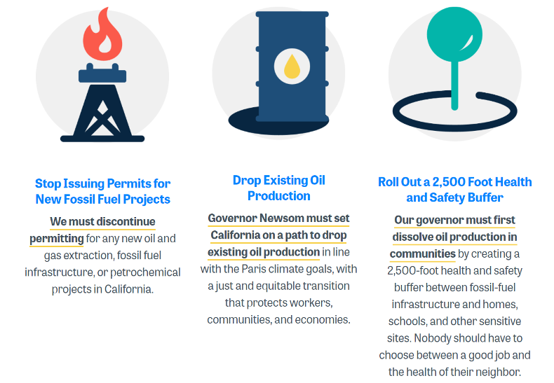
The recent oil spill near Orange County is a painful reminder of the dangers associated with fossil fuels.
Oil spills, air pollution, and single-use plastic waste are all preventable impacts from the fossil fuel industry. There is simply no safe way to drill. The only solution is a just transition away from an extractive fossil fuel economy.
Heal the Bay is calling on our elected officials and appointed agencies to end oil drilling in state and federal waters, and to decommission existing offshore drilling operations immediately. But it is not enough to ban all offshore drilling, when Big Oil will just ramp up their operations in our neighborhoods and public lands. We must end this harmful practice everywhere.
Let’s turn this preventable disaster into an opportunity to protect communities, our environment, and our local economy.
Numerous elected officials have stepped up to call for an end to offshore drilling – this needs to include an end for existing leases and an immediate decommissioning of offshore oil platforms and operations. We are heartened especially by Senator Min’s vow to introduce this type of legislation for California, by his and Senator Newman’s call for federal representatives to do the same. We will keep you updated on state and federal legislation and how to keep pushing it forward.
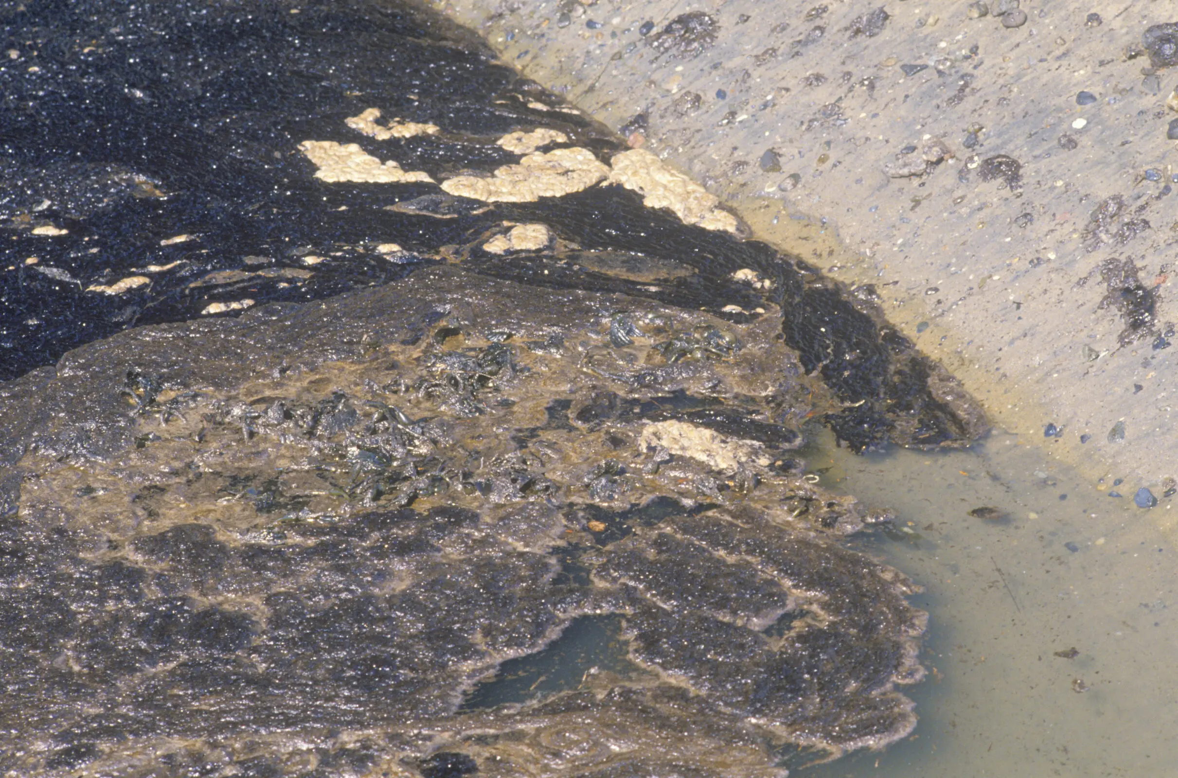
Estamos desconsolados e indignados. Este fin de semana se vertieron al océano 126.000 galones de petróleo crudo de una tubería cerca de Huntington Beach, en Orange County. El derrame de crudo ha tenido lugar en las aguas ancestrales no cedidas de los pueblos Acjachemen y Tongva.
LO QUE SABEMOS
Comenzó con informes de miembros de la comunidad que olían gas el viernes por la tarde y siguió el sábado con una mancha visible de petróleo en la superficie del océano. El anuncio oficial del derrame se produjo más tarde, el sábado por la noche: 126,000 galones de petróleo crudo brotaron de una tubería submarina hacia el agua circundante. El oleoducto (propiedad de Amplify Energy) transporta crudo desde la plataforma petrolífera Elly, ubicada en aguas federales frente a la costa de Orange County, hasta la costa en Long Beach. Según el LA Times, los criminólogos de la Guardia Costera de los EEUU están investigando detenidamente los eventos previos que llevaron al derrame y la posible negligencia en una respuesta tardía.
Los derrames de petróleo son terriblemente tóxicos para la salud pública y la vida marina. Las playas están cerradas y las aves y peces muertos y heridos ya están apareciendo en la orilla. Los mamíferos marinos, el plancton, los huevos de peces y las larvas también se ven afectados, ya que este crudo tóxico se mezcla con el agua del océano y se esparce por la superficie del agua, y hacia aguas más profundas también. A la 1:45 pm del 5 de octubre, solamente se habían recuperado 4,700 galones de los 126,000 galones derramados. Lamentablemente, este aceite también ha llegado a los sensibles y tan especiales humedales costeros de Talbert Marsh, un entorno natural crítico no solo para el hábitat de la vida silvestre, sino también para la calidad del agua ya que filtran naturalmente los contaminantes del agua que fluye a través de ellos; sin embargo, este humedal no puede filtrar la contaminación por hidrocarburos a tal escala.
Estos grandes derrames de crudo siguen ocurriendo porque las compañías petroleras priorizan las ganancias sobre la salud pública y el medio ambiente. Esto se evidencia por el hecho de que la industria petrolera ha buscado continuamente eludir las regulaciones y flexibilizar las restricciones a la extracción de petróleo. El peligro que plantea el patrón de comportamiento imprudente de la industria petrolera aumenta cuando se considera que gran parte de la infraestructura petrolera en California tiene décadas de antigüedad y se está deteriorando. Esta es la segunda fuga importante en una tubería en 6 años. La última fue en 2015, el vertido de petróleo de Refugio, un total de 142,000 galones de crudo que dañaron nuestra costa en Santa Bárbara.
Los derrames de petróleo son parte de un problema de contaminación mucho mayor. El impacto de los combustibles fósiles se deja sentir en todas sus etapas, desde la extracción hasta el desecho.
Los grandes vertidos de petróleo son desastrosos, aunque intermitentes. Pero la contaminación atmosférica de los lugares de extracción de combustibles fósiles y de las refinerías de petróleo situadas en tierra firme tiene un impacto perjudicial cada día para los barrios colindantes. Las comunidades de bajos ingresos y las comunidades de color están expuestas a riesgos desproporcionados para la salud y la seguridad debido a un historial de alta cantidad de perforaciones cerca de los lugares donde los vecinos viven, trabajan y llevan a cabo su vida cotidiana.
Entonces, ¿qué nos aporta toda esta perforación tan arriesgada? Al final lo que sacamos son productos como la gasolina, que contribuye a la crisis climática cuando se quema, o los plásticos que se usan una vez (o no se usan en absoluto) y luego se tiran “a la basura”, volviendo finalmente aquí, contaminando nuestros barrios y el océano.
LO QUE NO SABEMOS
Todavía no está claro qué es lo que causó el vertido de petróleo, ni cuándo empezó exactamente o cuándo se detuvo. La investigación en curso del personal de los equipos de buceo nos dará más información sobre lo que causó la ruptura que llevó miles de barriles de petróleo al Océano Pacífico.
El petróleo crudo es una mezcla de sustancias químicas tóxicas, como el benceno y otros carcinógenos, y se puede presentar en diferentes formas, con diferentes impactos en el ecosistema. Desgraciadamente, aún no sabemos qué tipo de petróleo se vertió, y las leyes de propiedad comercial permiten a las empresas petroleras mantener en secreto sus mezclas de petróleo y productos químicos. Tampoco sabemos cómo se supervisará el progreso de la limpieza y si se incluirán o no pruebas de calidad del agua en ese proceso. Basándonos en derrames anteriores, lo que esperamos es que las playas permanezcan cerradas durante varias semanas, y que los daños medioambientales duren años.
QUÉ NO HACER
En este momento, lo mejor que puede hacer es mantenerse alejado de la zona del vertido de petróleo por propia seguridad.
Aléjese de las playas manchadas de petróleo y cerradas, no entre al agua y mantenga las embarcaciones lejos de la mancha de petróleo existente. A día 4 de octubre, el puerto de Newport y el de Dana Point están cerrados, y en Huntington Beach se ha decretado el cierre de la playa.
Deje suficiente espacio para que los trabajadores de rescate y los equipos de limpieza de la Guardia Costera de los Estados Unidos y la Oficina de Prevención y Respuesta al Derrame del Departamento de Pesca y Vida Silvestre de California (CDFW-OSPR) puedan acceder y trabajar en el lugar del vertido. Si ve algún animal salvaje herido o empetrolado, NO intente intervenir por su cuenta. En su lugar, informe del animal a la Red de Atención a la Vida Silvestre Petrolizada en el 1-877-823-6926.
No pesque en la zona contaminada. CDFW ha emitido un veto de emergencia de la pesca. Cualquier captura de peces en esta zona está prohibida hasta nuevo aviso y CDFW está patrullando la zona concienzudamente. Si usted es un pescador, compruebe esta descripción detallada y el mapa para asegurarse de que se mantiene fuera de la veda de pesca por su propia salud y seguridad. Los mariscos y el pescado se pueden contaminar con el aceite y otros productos químicos del agua. Comer pescado y marisco de la zona contaminada puede hacer que enferme, y también es peligroso salir a pescar debido a la posible exposición a los gases nocivos del vertido.
QUÉ HACER
El equipo de Ciencia y Leyes de Heal the Bay está trabajando en llamar a la acción pública con demandas específicas sobre normativas que compartiremos pronto en nuestro blog y en nuestros canales de Twitter, Instagram y Facebook. Mientras tanto, hay muchas cosas que puede hacer mientras se mantiene a una distancia segura del vertido de petróleo.
Puede ponerse en contacto con la Red de Atención a la Fauna Silvestre Petrolizada de la UC Davis en el teléfono 1-877-823-6926 para informar sobre la fauna silvestre impregnada de petróleo. Ahora mismo, sólo el personal capacitado puede ayudar en los esfuerzos de limpieza. Sin embargo, si desea inscribirse para recibir formación para futuras emergencias, puede rellenar este formulario de voluntario para incidentes del OSPR o llamar a la línea de atención al voluntario al 1-800-228-4544 para obtener más información.
¡Manténgase informado! Preste atención a las noticias y los informes, siga la Respuesta al Derrame del Sur de California para obtener información y actualizaciones, y manténgase al tanto con Los Angeles Times, que está informando al día y en profundidad sobre esta emergencia.
Le animamos a que apoye y siga a estas organizaciones; están haciendo un gran trabajo para rescatar y proteger a la fauna del crudo, y defender el agua limpia y los humedales en buen estado a nivel local en Orange County:
Le sugerimos que siga y apoye a estas organizaciones; están luchando incansablemente porque se eliminen las perforaciones de pozos de petróleo en nuestro océano, en nuestros barrios y en cualquier otro lugar:
Esta lista NO es exhaustiva; hay muchas organizaciones y personas que realizan esta ardua labor. Si su grupo está trabajando en el vertido o luchando contra las grandes petroleras y le gustaría ser añadido a la lista anterior, contáctenos.
LA CONCLUSIÓN
Si seguimos dependiendo de los combustibles fósiles, los vertidos de petróleo y la contaminación atmosférica son inevitables y sus impactos seguirán siendo devastadores. La única solución es cerrar esta sucia industria y protegernos a nosotros mismos y al medio ambiente mediante una transición justa que nos aleje de la economía extractiva de los combustibles fósiles.
Permanezca atento, pronto publicaremos un seguimiento con las formas en que puede hacer oír su voz.
Come learn more about the future Inell Woods Park. We’re co-hosting an Open House there with the City of Los Angeles on Saturday, October 16 at 11 am to 1 pm. You are invited (see flyer below for details)!
Heal the Bay is committed to improving water quality in Los Angeles County’s watersheds through the creation of more green space. In addition to providing recreation areas and wildlife habitat, green spaces can function as essential multi-benefit stormwater solutions too. They improve local water quality, increase water reuse and supply, reduce carbon, and mitigate heat island effect.
This is why we are so excited to tell you about Inell Woods Park, Heal the Bay’s innovative stormwater park project near the intersection of McKinley Avenue and E 87th Place in South LA. Our work to build the park is being done in collaboration with LA City Councilmember Curren Price, North East Trees, California State Parks, and many local community members.
Inell Woods Park is a good example of how the Safe Clean Water Program aims to increase local water supply, improve water quality, and protect public health by focusing efforts on multi-benefit projects in communities that have been identified as severely disadvantaged with regards to access to green space and other socioeconomic factors. Multi-benefit projects are the most efficient and effective use of our taxpayer dollars because they are cost-conscious solutions that serve both community and environmental needs.
Heal the Bay celebra su 32nd aniversario albergando la mayor limpieza voluntaria en el condado de Los Angeles.
La organización medioambiental sin ánimo de lucro Heal the Bay hace una llamada a las personas voluntarias del condado de Los Angeles para que se unan al evento de limpieza más grande del mundo – El mes de la limpieza costera 2021 presentado por Portland Potato Vodka y Ocean Conservancy.
Se anima a los voluntarios y voluntarias a realizar limpiezas de playas y vecindarios por su cuenta durante todo el mes de septiembre, y como punto culminante, a unirse al evento especial del Día de Limpieza Costera (Coastal Cleanup Day) el sábado 18 de septiembre de 9 am a 12 pm en más de 25 sitios costeros, interiores y fluviales en area metropolitana de LA. Tenga en cuenta: para los grupos presenciales del Día de Limpieza Costera el 18 de Septiembre hay un aforo muy limitado debido a las precauciones de salud y seguridad de COVID-19, por lo que serán organizados por estricto orden de llegada. Usted puede saber de antemano cuándo se abre la inscripción para el voluntariado del Día de Limpieza Costera suscribiéndose al Boletín Azul de Heal the Bay.
El Mes de la Limpieza Costera invita a angelinos, angelinas y visitantes de toda la región a recoger basura y desperdicios dañinos y antiestéticos mientras exploran el medio ambiente, disfrutan del aire libre, y participan en un proyecto de ciencia comunitaria. El evento es parte de la Limpieza Costera Internacional que ha movilizado a millones de personas voluntarias por todo el mundo.
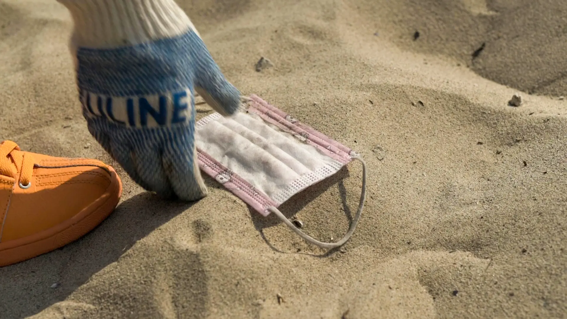
El año pasado, el equipo voluntario de Heal the Bay retiró 40,101 piezas de basura de los vecindarios, parques, senderos y playas, y por primera vez en la historia, los equipos de protección personal (máscaras y guantes) estuvieron entre los diez artículos de basura más encontrados en las zonas al aire libre favoritas de Los Angeles.
Las personas voluntarias pueden registrar la basura que encuentran usando la aplicación Clean Swell o manualmente a través de la tarjeta de datos de Heal the Bay. Los datos recopilados durante el Mes de la Limpieza Costera se utilizan para educar e informar a legisladores, administradores de saneamiento y desechos y comunidades sobre los tipos y fuentes de basura que hay en nuestro entorno. Las colillas, los utensilios, envoltorios y botellas de plástico y sus tapas siguen siendo los artículos más comunes que encuentran las personas voluntarias. Otros artículos comunes incluyen bolsas de plástico, popotes de plástico y agitadores, recipientes de plástico para llevar, tapas de plástico y recipientes de espuma para llevar.
Durante los últimos 20 años, los voluntarios y voluntarias de Heal the Bay han eliminado más de 4 millones de piezas de basura y escombros de las playas del condado de Los Angeles. Si bien la limpieza de playas es nuestra última defensa para erradicar la basura en la costa, todavía hay 8 millones de toneladas de plástico que se arrojan a nuestros océanos cada año. Eso equivale a un camión de basura lleno cada minuto. Heal the Bay exige una acción estatal para abordar esta crisis de contaminación y aboga por políticas y prácticas que reduzcan el plástico en el origen.
El Mes de la limpieza costera de Heal the Bay 2021 es posible gracias al apoyo de Portland Potato Vodka, Ocean Conservancy, la Comisión Costera de California, Water for LA, la ciudad de Santa Mónica y TIME TO ACT Entertainment.
Se recuerda la participación de manera segura seleccionando un lugar accesible, usando una máscara cuando estén en público, usando guantes al manipular la basura y participando solamente cuando gocen de buena salud para ayudar a prevenir la propagación de COVID-19. El aforo para el evento de Heal the Bay el 18 de septiembre es limitado debido a las precauciones de salud y seguridad, razón por la cual desde Heal the Bay se alienta a los voluntarios y voluntarias a participar en limpiezas autoguiadas durante todo el mes.
Heal the Bay es el coordinador oficial del Día de Limpieza Costera y el Mes de Limpieza Costera en el condado de Los Angeles en asociación con la Comisión Costera de California y Ocean Conservancy. La organización sin ánimo de lucro busca personas voluntarias de todas las edades y capacidades físicas para participar; no se necesita formación ni experiencia. Los organizadores animan a los voluntarios y voluntarias a “BYO” (traer sus propios baldes, bolsas reutilizables y guantes reutilizables para recoger la basura). Los suministros de limpieza están disponibles bajo pedido y por orden de llegada.
Acerca de Heal the Bay
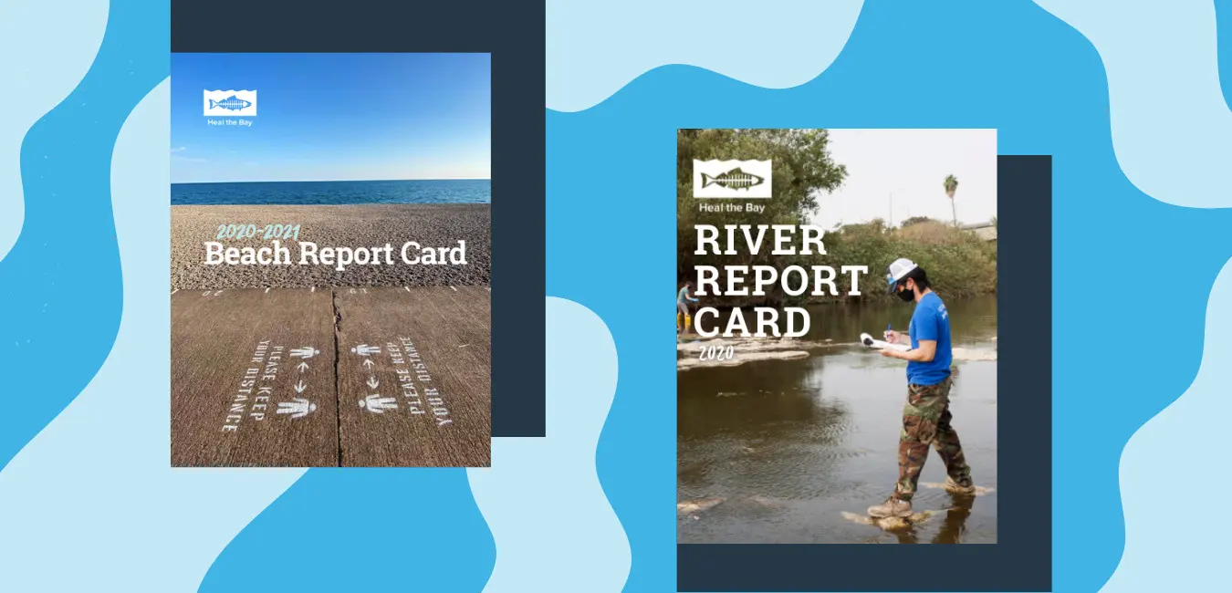
Heal the Bay es la organización medioambiental sin ánimo de lucro líder en el condado de Los Ángeles y está dedicada a proteger las aguas costeras y las cuencas hidrográficas. La organización tiene una historia de 36 años en el uso de la ciencia, la educación, la defensa y la acción comunitaria para proteger el agua limpia. El grupo realiza dos limpiezas de playa por día de media. Heal the Bay también emite calificaciones de calidad del agua para cientos de playas de California cada semana a través del Beach Report Card con NowCast, proporciona calificaciones semanales de calidad del agua para docenas de áreas de agua dulce con el River Report Card, educa a miles de estudiantes locales cada año y opera el galardonado Heal the Bay Aquarium. Visite healthebay.org para obtener más información.
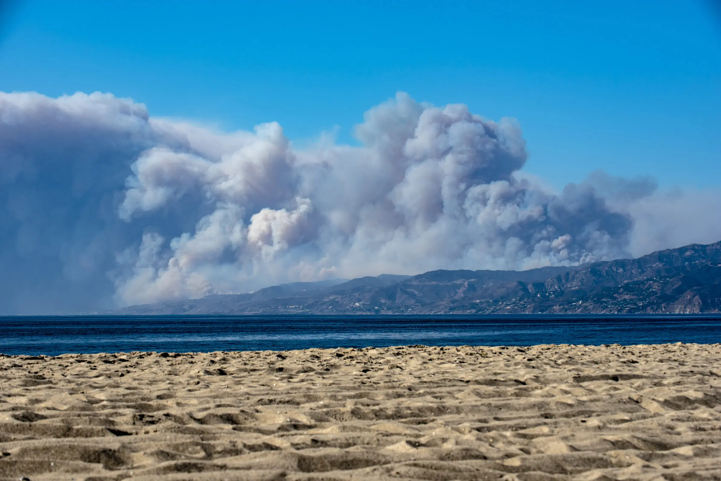
Wildfires rage in California year after year, with increasing frequency and intensity. This is driven by the climate crisis creating hot, dry conditions for wildfires to start, spread, and burn out of control. Spring comes earlier, melting snow more quickly, and reducing water availability during summer, which is lasting longer with more extreme temperatures. Less frequent but more intense rain along with with the extra snowmelt in spring triggers vegetation growth; then the long, hot summers dry out that vegetation, covering the state with kindling. These climate impacts, coupled with a systemic departure from smart tribal land management practices like controlled burns, leaves us setting new wildfire records every single year, destroying ecosystems and devastating communities.
2021 has been the worst wildfire season to date, with over 1.5 million acres burned across California already, and the season has just begun. So far this year, the Pacific Northwest has felt the brunt of this wildfire season, but Los Angeles is not out of the woods. The fire season for Southern California typically spans October through December, which is why Los Angeles officials urge residents to be prepared.
Wildfires, particularly the extreme events that we are experiencing more and more each year, have both immediate and long-term impacts on the health of people and the environment. But did you know that wildfires also impact the health of our waterways? Heal the Bay interviewed two experts this week on the impacts of wildfires on public health and on water quality.
We learned a lot from these experts. By removing vegetation, wildfires increase sediment and pollution runoff, which can affect both recreational and drinking water. Wildfires also release smoke pollution into our atmosphere with contaminants that are harmful to public health. These airborne contaminants eventually settle out onto surfaces like streets, sidewalks, and rooftops, where they remain until stormwater washes it all into our waterways. Scroll down to find links to these recorded interviews or to check out the transcripts for both of these conversations.
We urge you to take climate action now, whether through global systemic change, or directly in your home or your neighborhood to prepare for emergencies and make your community more climate resilient. Take the climate challenge with us – start by picking one action you can take today. But don’t stop there! Consider the skills, experiences, and resources you have to offer, and create a personal list of climate actions.
One action you can take right now is to sign up and join Heal the Bay virtually at 6 PM on Monday August 30th to learn about the Cool City Challenge, and how to become a Cool Block Leader to make real change in your neighborhood to tackle the climate crisis.
Host: Alex Preso (Manager of Outreach, Heal the Bay)
Expert: Marisol Cira (Graduate Researcher in Civil and Environmental Engineering, UCLA)
Alex: Please introduce yourself and provide a little background on some of the work you do.
Marisol: I am a graduate researcher at UCLA in the Civil and Environmental Engineering Department, where I study the impacts of wildfires on beach water quality.
Alex: How does a wildfire impact water quality, specifically in the Ocean?
Marisol: Wildfires remove vegetation and alter the soil. When it rains, the vegetation and the soil that remain can no longer filter and retain the water like they used to. This increases the sediment and runoff that carry harmful contaminants and eventually make their way into our reservoirs, rivers, and oceans.
Alex: That is definitely not ideal! Would that have any impact on our freshwater and drinking water, too?
Marisol: Yes, wildfires do impact both recreational and drinking water quality. For example, they contaminate our groundwater because the contaminants can reach the water table, and the loss of vegetation can affect the aquifer recharge. In addition, the amount of sediment and runoff that flows into our reservoirs increases the maintenance needs and costs for that reservoir. Similarly, for our drinking water treatment plants, they might have to change operations to meet the water quality standards, and that also increases cost. Lastly, the contaminants that reach the beaches can be harmful to beachgoers and to wildlife.
Alex: Would you mind expanding on what kind of contaminants those are, and how they end up getting into our water?
Marisol: Studies have reported increases in nutrients, metals, water temperature, and turbidity, among other things. Following the 2018 Woolsey Fire, which burned approximately 100,000 acres in the Santa Monica Mountains, researchers reported increases in fecal indicator bacteria at beaches in Malibu. Although the fecal indicator bacteria are not harmful themselves, monitoring agencies do use them to indicate the presence of pathogens in water. What may be happening is that the wildfires, and the debris flows that follow, damage and disrupt the sewage infrastructure which contaminates downstream water quality with fecal matter. And, as mentioned earlier, the vegetation and the soil can no longer filter and retain these contaminants.
Alex: Heal the Bay tracks water quality testing at over 500 beaches statewide. Are wildfires impacting water quality right now?
Marisol: Water quality may return to normal within hours, or it could take up to 10 years, depending on the severity of the burn, the precipitation, and the contaminants. Specifically for fecal indicator bacteria, researchers reported elevated levels for up to 6 months. However, these levels are still being monitored as the burn area recovers.
Alex: I’ll give you a few more minutes to talk a little bit more about the research that you are doing, and the recent findings.
Marisol: We saw increases in the fecal indicator bacteria and turbidity following the Woolsey Fire, specifically after rain events, which is a concern for the health of beachgoers and wildlife. We hope that this research is able to help agencies protect our oceans and treat these contaminants.
Alex: Do you have any advice on how other people can get involved?
Marisol: Wildfire activity has increased globally and here in the Western US due to climate change. The frequency, duration, and season length are longer. It is important that we support candidates and measures that address climate change, and that we do what we can to reduce our carbon footprint.
Host: Kayleigh Wade (Associate Director of Campaigns and Outreach, Heal the Bay)
Expert: Gilmar Flores (Senior Manager of Programs and Research, Breathe Southern California)
Kayleigh: Please introduce yourself. What’s your name, and what is your role at Breathe Southern California?
Gilmar: Thank you so much for having me on today. Hello everyone, my name is Gilmar Flores and I am the Senior Manager of Programs and Research at Breathe Southern California.
Kayleigh: What is Breathe Southern California’s mission? Can you give us a quick run-down of your organization?
Gilmar: Breathe Southern California is a non-profit organization. Its mission is to promote clean air and healthy lungs. We do that through education, research, technology, and advocacy. Our organization has over 50 programs that target with our mission of clean air and healthy lungs. We offer this through youth programs in regards to asthma, environmental factors, and vaping; and through community programs in regards to wildfires, asthma, and lung disease. We also have a professional membership society called the Trudeau Society, where professionals in the field can attend lectures and network.
Kayleigh: That is important information to know. Every year we have a wildfire season, so thank you for sharing those resources. How does wildfire smoke play a role in the air pollution problems facing Southern California?
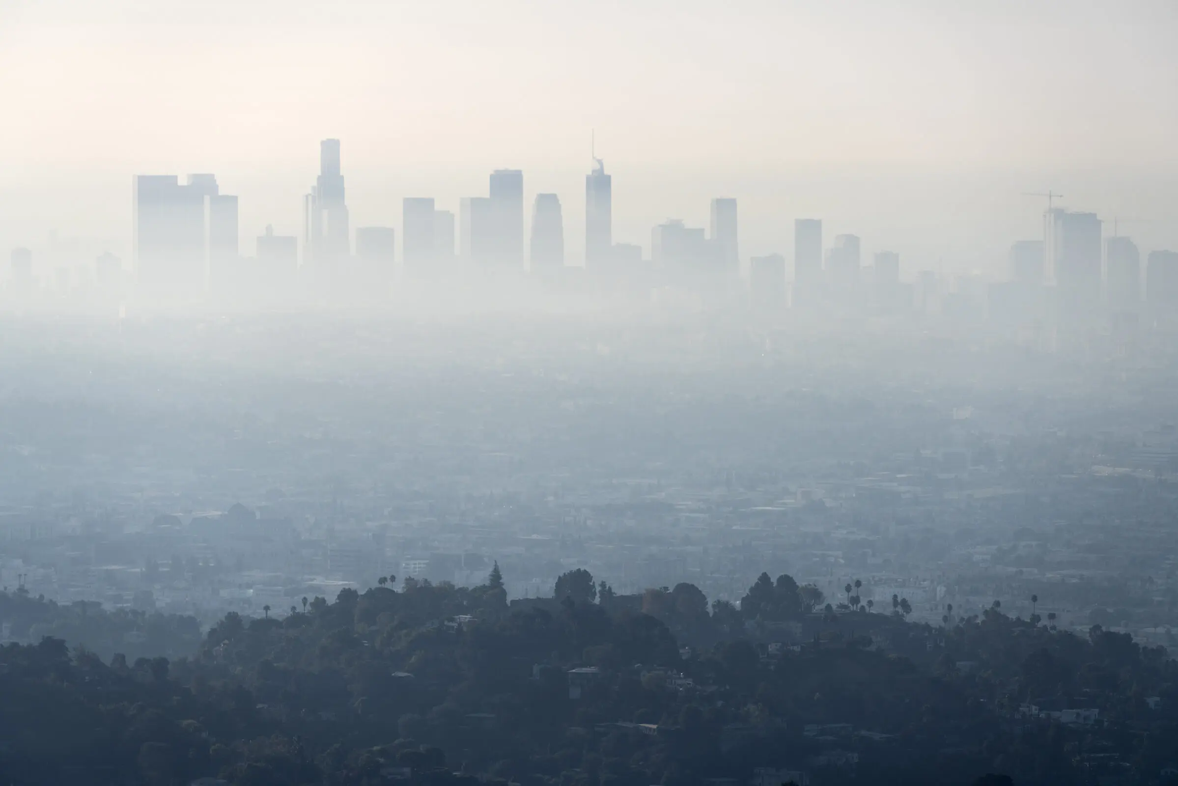
Gilmar: Back in 2019, California was home to 15 of the 30 places in the United States with the worst air pollution. Out of those 15, San Diego ranked #10; Los Angeles, Long Beach and Anaheim ranked #6; and Riverside and San Bernardino ranked #2. On an average day, the air quality index of these cities in Southern California were in the moderate levels. For those who do not know what the air quality index is, it is an index that ranges from good, moderate, unhealthy, very unhealthy, and hazardous. So if you think about that, an average day in those cities were not even in the good section of air quality. We’re in the moderate section. So when wildfires burn within 50 or 100 miles of those cities, it causes the air quality to be 5 to 15 times worse than normal, and often 2 to 3 times worse than normal even on a non-fire day. So during these wildfire seasons, the air quality index in these parts of the country can reach hazardous levels, which are very unhealthy not only for the vulnerable populations, but for everyone.
Kayleigh: What is the connection between environmental injustices, public health, and wildfires?
Gilmar: There are a lot of connections, but one that I will cover today is the resource availability that these vulnerable populations tend not to have. One example that I will focus on is asthma. During fires, air quality management districts will urge people to stay inside with windows closed and doors closed until smoke levels subside. This is mainly targeted to vulnerable populations such as the elderly, those who have respiratory illness or cardiovascular illness, and also for children. But the problem is that keeping the windows and doors closed only helps if your windows and doors can actually close and keep the smoke out. There are blocks of old apartment complexes, either in Los Angeles, Riverside, or the Bay Area where smoke still comes through, and some of these complexes do not have installed ventilation systems that can help remove the indoor toxins from these settings. We know that in low-income communities, there tends to be a lot of chronic disease, like asthma. So these communities are usually more effected by the wildfire seasons. There are more examples. If we had more time, we could talk about native American tribes located in areas where fires are more prominent. We could also talk about farm workers in Ventura County who are exposed. They still have to work during wildfires, and don’t always have the proper masks while working, so cannot avoid the harms of wildfire smoke.
Kayleigh: More often than not, people do not have access to those resources, especially in low income communities and communities of color. What are some tools you would recommend to promote wildfire resilience?
Gilmar: There are several steps you can take to keep your family or yourself safe during wildfire seasons. But the primary way to be resilient would be to stop yourself from breathing smoke, especially when there is a wildfire nearby. A few steps that you can take is to check air quality. You can use websites such as https://fire.airnow.gov to check the air quality, avoid going outside, close windows and doors, run the AC for circulation and check the filtration, use air purifiers at home if possible, avoid frying foods while inside, wear N-95 masks (don’t just buy is and have it there – when you purchase it, test it out and make sure it fits well and covers your whole face), be aware of any evacuation orders, and be prepared to evacuate.
Kayleigh: What are the long-term impacts of pollution from wildfires on communities that are already impacted by environmental racism?
Gilmar: These communities are already experiencing health hazard burdens by just living near landfills, power stations, and major roads. They often struggle with contaminated water supply or elevated airborne particulate matter. And then these communities are exposed to longer harsher air conditions because of wildfires. We see a correlation between these kinds of environmental exposures and cardiovascular disease such as heart attacks and strokes, pulmonary disease such as lung cancer and COPD (chronic obstructive pulmonary disease), emphysema, pneumonia exasperated among children and the elderly, low birth weights, and premature deaths.
Kayleigh: That information is very heavy, but thank you for sharing it. It is very helpful to pair that knowledge with the industrial activity that is happening in these communities. What types of pollutants, specifically, are found in wildfire smoke and ash?
Gilmar: When wood and other organic materials burn in wildfires, it produces a mixture of fine particulate matter and dangerous gases such as carbon monoxide, or volatile organic compounds. One of the major pollutants found in wildfire smoke is particulate matter (P.M. 2.5), which is a mixture of tiny solid and liquid droplets suspended in the air, which can be inhaled deeply into the lungs. The concern is that these particles, which make up most of the plume of smoke from wildfires, can get deep into the lungs and cause biological damage. Particulates can also effect the cardiovascular system by causing inflammation, and can also effect the nervous system. Some of the smallest particles can even cross into the blood stream and travel through other parts of your body effecting other organs.
Kayleigh: At some point after a wildfire, the atmosphere eventually clears out. But just as throwing away a piece of trash does not actually mean that it is gone, all of that pollution must remain in our environment in some way. Where does all of that pollution go?
Gilmar: Unfortunately, the pollution will eventually fall down to the ground. It’s going to fall onto the floors of our homes, onto vehicles, buildings, trees, and plants. It can even extend far beyond where the fire was actually burning. As an example, I visited Crater Lake up in Oregon back in 2019, and from the top of that mountain we could see the smoke from California crossing over, because it does not have any boundaries. So this pollution definitely will fall onto the ground and will either disburse into the soil or into water, and eventually make its way out to the ocean, effecting not only plant life but also the wildlife that lives in the ocean.
Kayleigh: It’s so important to remember that everything is connected, and there are no boundaries. Pollution will remain in our environment and continue to impact our health. What long-term effects does wildfire smoke have on the ability of our communities to be resilient to the climate crisis?
Gilmar: Wildfires will have far reaching impacts and effects and will ripple through communities as climate change continues to occur. Habitats will continue to get damaged, both on land and also in to sea. Air quality will be degraded, causing long term health impacts not only for us humans, but also for other animals. There will also be drinking water supply contamination. However, communities can still employ a number of strategies to be more resilient to wildfires. This includes zoning and building policies, landscape regulations, vegetation and forestry management, and public education and preparedness campaigns.
Kayleigh: Is there anything else you’d like to add or talk about that we didn’t already cover?
Gilmar: Extreme wildfires are becoming a yearly thing, especially here in the west. There are a few websites that I want to mention so all of you can be prepared, not only for those who suffer from a lung disease, but for everyone, especially if you have loved ones who do. A good website to follow is https://fire.airnow.gov, which provides you the air quality map index and smoke information when there are fires. It will show you what the air quality index is at that time and lets you know if you need to close the windows and stay inside. Another website is https://ww2.arb.ca.gov. They provide a lot of resources there. I know a lot of individuals do not have the luxury of owning an air purifier, so they provide examples of things you can do to still improve indoor air quality in your home during wildfire season. And you can follow Breathe SoCal on our social media platforms for awareness, and for additional information for workshops on lung disease, asthma, or environmental stewardship.
Kayleigh: We actually have a question from the audience: Do either of you know why, in California, there isn’t more fire prevention even though it’s become a yearly phenomenon.
Gilmar: There are preventative measures taken. Some examples include energy companies like SoCal Edison providing grants to non-profit organizations to provide those resources to communities. But one of the things that definitely has to happen is for folks to speak to elected officials and share your ideas, possibly for future legislation.
Kayleigh: There is definitely a need for infrastructure and a need for policy if we want to be more resilient as a community as the climate crisis accelerates.
At Heal the Bay Aquarium, we believe that there are 52 Shark Weeks in a year, so we’re keeping all the #SharkWeek learning going. It’s important to share and teach facts, not fear, as we all work towards protecting our ocean environment and the animals that call it home. Shark conservation is a 24/7 job, so let’s continue this deep dive into learning more about these critically important, and often misunderstood, creatures.
California is known for its incredible richness and variety of ecosystems—both on land and under the sea. Venture across the Golden State and you’ll cross coastal wetlands, lush wooded forests, and the vast deserts in Death Valley. Dive below the waters off our coastline and see the fairytale-like beauty of our kelp forests, the infinite expansiveness of the sandy seafloor, and the rocky shore dynamics of our tide pools. From abalone, to sea lions, hermit crabs to Mola mola, there is a wealth of marine diversity right in our Bay.
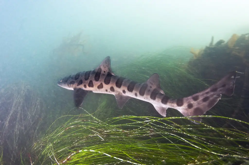
So, who are our elasmobranch neighbors? In our local waters, there are at least 23 different kinds of sharks, and over a dozen types of rays and skates (the triangular-shaped Rajidae—not the retro kind spotted weaving down the boardwalk). Wade into our shallower waters and you may see the slim, spotted shadow of a leopard shark (Triakis semifasciata) sashay by, on the hunt for crustaceans and clams on the sandy bottom. Head out a little further with the surfers and you may even get the rare, incredible opportunity to spot our resident (albeit juvenile) landlord: the great white shark (Carcharodon Carcharias). From long-tailed thresher sharks to the chiropteran-like bat rays, you never know what you’ll “sea” when you explore our coast. At our Aquarium, we exhibit marine species that you can find right next door in Santa Monica Bay. Learning about these local animals allows our visitors to see what our clean water mission is all about: not only protecting public health, but also protecting the thousands of different kinds of marine life that call it home—from seabirds and fish, to marine mammals and phytoplankton—all are part of the southern California ecosystem.
Let’s meet the locals in our Sharks & Rays Exhibit!
<
►
>
Swell sharks (Cephaloscyllium ventriosum) are a visitor favorite because when you’re observing them in the exhibit, you’re now in the “Splash Zone”, due to the fact that they literally spit water while they swim around. They’re so aptly named because when agitated, swell sharks will hold on to their caudal fin with their teeth and swell up with water, making it more difficult for predators to bite them or pull them from their rocky den. Ever seen a Mermaid’s Purse? Swell sharks are also oviparous, which means they lay keratinous egg cases. Developing swell shark pups take about 9-12 months until they’re ready to hatch into adorable, 6 inch (15 cm) long baby sharks. Check out Baby Shark Watch to see a swell shark grow from egg to pup!
Horn sharks (Heterodontus francisci), are named for the large horns in front of each dorsal fin. These horns are used for protection against predators, making horn sharks extremely difficult to eat. Imagine trying to swallow a sandwich with the toothpicks still holding it together—you’d have a pretty hard time getting that down. These oviparous sharks also have a uniquely shaped mouth that allows them to “suck” in food and forage through sand for a tasty crab or some other buried seafloor invertebrate. The scientific name Heterodontus comes from the Greek words “heteros” and “odont”, meaning “different teeth”. Horn sharks have sharp pointy teeth in the front, and crushing molar-like teeth in the back. This is why they’re one of the few shark species that can actually eat a spiky sea urchin (sometimes staining their teeth with the urchin pigment).
Round stingrays (Urobatis halleri), lovingly known as “sea pancakes” by our visiting students, are commonly found in sandy bottom habitats, and typically hang around intertidal areas down to depths of about 15 m (50 ft). Stingrays are viviparous (live birth), and will have between 1-6 pups that are about the size of the palm of your hand (2.5-3 inches or 6-7.5 cm).
To the right, to the right…to the left, to the left…now shuffle! Ever heard of the Stingray Shuffle? It’s actually the best way to protect both yourself and unsuspecting stingrays that may be camouflaging in the sandy bottom below you when you head into the waves. If you slide or shuffle your feet in the sand as you enter and move about the ocean, rays will feel the movement from your feet, and will move somewhere else to avoid contact. If you walk in normally (especially around this time of year during stingray mating season), you may accidentally step on a ray, which will then defend itself by using the venomous barb on their tail. The venom of the round stingray is not dangerous to humans; however, it is extremely painful. If stung by a ray, the best course of action is to seek help from the nearest Lifeguard, and soak the affected area in very hot water. This actually denatures the proteins in the venom, and will hopefully help provide some relief from the sting. This is also the best treatment for sea jelly stings, since contrary to popular myth (and TV sitcoms), peeing on the jelly sting can actually make the pain worse!
During our closure throughout 2020, we were busy at work refreshing our exhibits and creating fun, new experiences for our visitors for when we could safely reopen. We o-fish-ally re-opened our indoor gallery on June 12, 2021, and visitors can now enjoy our upgraded, interactive Sharks & Rays Touch Tank Exhibit! Get up close and feel the sandpapery touch of a swell shark’s skin from their dermal denticles (“tooth-skin”), or the velvety softness of a round stingray. Gentle interactions with these animals help to dispel long-held myths about sharks being scary, mindless, man-eaters.
Lurking. Stalking. Chasing. Attack. These are all familiar (and unfairly given) terms when we see any news about encounters between humans and sharks. Sharks have been around on this planet for at least 400 million years. They’re a keystone species, which means as apex (top) predators, sharks are critically important to a healthy ecosystem and marine food web. Just like the tumbling of a Jenga tower when we pull out a single, structural-load-holding piece, the removal of sharks can decimate the delicate balance of the ocean environment. We’ve seen the same impacts on land ecosystems with the human-led removal of wolves from Yellowstone National Park. Without these apex predators keeping elk populations in check, the land suffered from erosion and deforestation, affecting more than 200 other species of animals living in that ecosystem. Sharks usually take a long time to reproduce, and most don’t have that many young at a time. Female great white sharks usually aren’t even sexually mature for at least 1-2 decades, and their young take more than a year to gestate. Sharks are already vulnerable to the impacts of pollution and climate change, and data show that worldwide shark populations have declined by almost 99% due to the additional stress of overfishing.
So, what can we do to help protect sharks? One super easy way is to spread facts, not fear. Even though encountering sharks in the wild can still be a scary thought, sharks have no desire to eat us (honestly—do we really think we taste that good?). Sharks are actually probably much more afraid of you than you are of them, and when they encounter people, their usual reaction is to swim away, hide, or out of simple curiosity just check out this silly-looking animal scooting around the water. Being conscientious about sustainable seafood choices, and going zero-waste and plastic-free as much as possible can go a long way towards shark protections. Destructive fishing methods not only cause habitat loss, but harms millions of sharks each year as bycatch. Just looking at the Pacific Ocean alone, an estimated 3.3 million sharks are accidentally caught each year as bycatch on longlines that were targeted for other fish. Supporting bans on shark fin products and shark finning can also add protections to critically declining shark populations, because we can eliminate the market for fins by passing laws prohibiting their sale. Globally, at least 70-100 million sharks are killed each year just for the inhumane shark fin trade. Heal the Bay, along with partners and supporters, successfully led the charge to ban the sale and possession of shark fins in California in 2013. Right now, the Shark Fin Sales Elimination Act (H.R. 737) is still waiting for a vote in the Senate. The House passed this bill in November 2019, and the bill would “prohibit the sale, purchase, and possession of shark fins in the United States”. Your voice and action can help protect what we all love. Helping to teach others about the importance of sharks is a great way to help change the way people think about sharks. For the record, we think they’re “swell”.
Learn more about shark conservation with these great organizations and researchers:
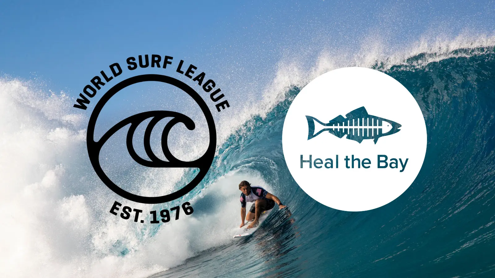
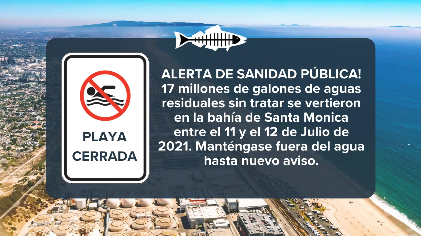
On the heels of the 17-million-gallon sewage spill in the Santa Monica Bay on July 11-12, Heal the Bay and the World Surf League—two Santa Monica-based organizations—are partnering to expand Heal the Bay’s Beach Report Card with NowCast to give beachgoers more information, more swiftly, about potential risks from poor ocean water quality at California’s most popular beaches and surf spots.
Heal the Bay and the World Surf League (WSL) are announcing a multi-year partnership in support of Heal the Bay’s Beach Report Card, activating local surfers to protect the health of 150 million beachgoers in California, and increasing surfing community outreach through social media and local competition events in California.
Summer is here, temperatures are hot, and more people are flocking to the beach. With roughly a thousand miles of shoreline, California has one of the longest and also most diverse coasts of any state in the USA. California offers an incredible array and variety of beaches and waves. Several offer pristine bays with 30-feet visibility underwater, others iconic views and world class waves.
While the waves may look clear, many beachgoers have no idea they might be swimming in a bacteria-polluted area, especially near piers, storm drains, and enclosed harbors with poor water circulation. One in 25 beachgoers will get sick swimming or surfing in polluted water near a flowing storm drain. Youth and seniors are particularly vulnerable to illnesses related to bacterial pollution.
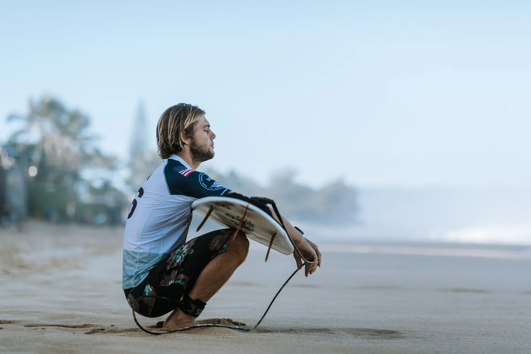
“As a surfer, I have spent a ton of time in the water since I was a little kid. The water quality at my local beaches is something I have always been observant of. Unfortunately, there have been many times where the water quality has seemed very low and I’ve gotten sick from surfing in dirty water. I’m thrilled the World Surf League is partnering with Heal the Bay on the Beach Report Card for California. Everyone deserves access to clean water to surf, swim, and enjoy this precious resource – our one ocean!” says Conner Coffin, WSL Championship Tour surfer.
The Beach Report Card is Heal the Bay’s education, advocacy, and public health notification tool for people concerned about the water quality at their favorite beaches across the state of California. The latest beach water quality grades are displayed alongside historical trends. The program also has science and policy initiatives to improve water quality, advance water quality testing methods, and ensure beachgoers have equitable and immediate access to beach water quality information through environmental and public health legislation and regulation.
Dr. Shelley Luce, Heal the Bay CEO & President says, “We’re excited to announce our partnership with the World Surf League. Clean ocean water has multiple benefits. It sustains healthy ecosystems and thriving wildlife, it mitigates impacts from the climate crisis, and it provides a safe place to enjoy the outdoors and cool off. We thank our partners at the World Surf League for working together with us to protect clean water starting in Santa Monica, stretching up and down the California coastline, and rippling out globally.”
The World Surf League is sponsoring the Beach Report Card for three-years, supporting the popular Annual Report, which highlights the coveted Honor Roll list as well as the notorious Beach Bummers list. The World Surf League is also investing in the growth of NowCast, Heal the Bay’s daily water quality prediction program.
“The WSL is incredibly proud to partner with Heal the Bay to provide tools and resources such as the Beach Report Card for all ocean lovers to be informed about water quality prior to heading to their favorite beach. As a global sports league, the future of our sport depends on a healthy ocean. Our focus as a league is to protect the ocean and beaches by inspiring climate action, preventing pollution, and conserving our coasts through campaigns like We Are One Ocean,” said Erik Logan, WSL CEO.
Heal the Bay is expanding NowCast to include 40-50 beaches over the next three years.
About Heal the Bay and the Beach Report Card
Heal the Bay is an environmental nonprofit dedicated to making the coastal waters and watersheds in Greater Los Angeles safe, healthy, and clean. We use science, education, community action, and advocacy to fulfill our mission.
Heal the Bay’s Beach Report Card is the only comprehensive analysis of coastline water quality in California. We provide water quality grades for more than 700 beaches weekly from Washington to Mexico during the peak beach-going season, with approximately 500 locations in California. Each location is assigned an A to F grade based on the health risks of swimming, surfing, and entering the water at that location.
Established in 1976, the World Surf League is the home of the world’s best surfing. A global sports, media and entertainment company, the WSL oversees international tours and competitions, a studios division creating over 500+ hours of live and on-demand content, and via affiliate WaveCo, the home of the world’s largest high performance, human-made wave. Headquartered in Santa Monica, California, the WSL has regional offices in North America, Latin America, Asia Pacific, and EMEA. The WSL is dedicated to changing the world through the inspirational power of surfing by creating authentic events, experiences, and storytelling to inspire a growing, global community to live with purpose, originality, and stoke.
Esta es una historia en desarrollo y les mantendremos actualizados a medida que vayamos teniendo más información.
¿Cuándo sucedió el vertido?
El vertido de aguas residuales comenzó el 11 de Julio de 2021 a las 7 pm y paró sobre las 5 am del 12 de Julio de 2021. La Oficina de Saneamiento de la ciudad de LA nos dijo que el vertido había parado sobre las 5 am y que todas las aguas residuales ya están siendo tratadas normalmente.
¿Cómo fue de grande?
Al parecer 17 millones de galones de aguas residuales sin tratar se vertieron a través del desagüe de 1 milla, que se encuentra situado directamente enfrente de la planta de tratamiento de aguas Hyperion en El Segundo.
¿Qué playas han sido afectadas?
Ahora mismo Dockweiler State Beach y El Segundo Beach están cerradas al público. La Ciudad de Los Angeles y el Departamento de Salud Pública del Condado de Los Angeles están haciendo pruebas en las playas y el agua de la bahía de Santa Monica. Se puede encontrar más información en la página web del Departamento de Salud Pública del Condado de Los Angeles.
¿Qué puede hacer el público para protegerse?
Recomendamos al público que se mantenga fuera del agua en la Bahía de Santa Monica hasta nuevo aviso. Además, consulte el boletín de calificaciones de las playas para conocer las últimas alertas sobre la calidad del agua del océano en California, y el boletín de calificaciones de río para obtener información sobre la calidad del agua dulce en las pozas del condado de Los Ángeles.
¿Qué problemas causa esto a las personas y a la fauna marina?
Las bacterias y los virus de las aguas residuales no tratadas son extremadamente peligrosas para la gente y traen consigo una variedad de enfermedades. Restos como tampones o basura plástica, cuando quedan sueltos en la bahía, pueden albergar bacterias y pueden enredar a la fauna, aunque parece ser que en este caso ese tipo de restos quedaron filtrados antes de llegar a la bahía.
¿Por qué ha sucedido esto?
Tenemos conocimiento de que la toma de entrada a la planta Hyperion de El Segundo estaba obstruida de forma severa, lo que causó una inundación en las instalaciones. Las aguas residuales salieron de la instalación sin tratar a través de la tubería de 1 milla y el desagüe.
¿Cuál es el origen y cómo podemos hacer que se hagan responsables del vertido?
Lo que ha pasado es responsabilidad de la Ciudad de Los Angeles y su Oficina de Saneamiento. La ciudad normalmente hace un buen trabajo conteniendo y tratando cientos de millones de galones de aguas residuales cada día – pero cuando se produce un vertido la Ciudad debe actuar deprisa para avisar al público, y debe descubrir y arreglar la causa para prevenir más vertidos.
¿Cómo se pueden prevenir los vertidos de aguas residuales?
Las mejores medidas preventivas son un buen mantenimiento del sistema y un uso debido de los inodoros por parte del público (no tirando en ellos basura como plásticos).
¿Cada cuanto tiempo suceden estos vertidos de aguas residuales?
El último vertido de importancia de aguas residuales en el condado de Los Angeles sucedió en 2015. Sin embargo, los vertidos pequeños no son algo especial. Entre 2020 y 2021, 75 vertidos mandaron un total de 346,888 galones a ríos, lagos y arroyos del condado de Los Angeles. Un vertido de 222,542 galones en febrero de 2021 mantuvo todas las playas de Long Beach cerradas; esta es un área monitoreada por el boletín de calificaciones de las playas de Heal the Bay. Un total de 39,621 galones de aguas residuales se vertieron en el río de Los Angeles, y 140 galones en el arroyo de Las Virgenes; ambas vías de agua dulce monitoreadas por el boletín de calificaciones de río de Heal the Bay.
Para más información sobre vertidos de aguas residuales, visite la página web del Departamento de Salud Pública del Condado de Los Angeles.
Heal the Bay releases scientific reports and annual bacterial-pollution rankings for hundreds of beaches in California and dozens of freshwater recreation areas in Los Angeles County during 2020 – 2021.
The thirty-first annual Beach Report Card study assigns A-to-F letter grades for 500 California beaches based on levels of fecal-indicator bacterial pollution in the ocean measured by County health agencies. In addition, we ranked water quality at 28 freshwater recreation areas in Los Angeles County during summer 2020 and shared findings from the third annual River Report Card.
Highlights from the Beach Report Card
Hotter days are here! Beach days and river trips are at an all-time high. The good news is California beaches had excellent water quality in summer 2020. 93% of the California beaches monitored by Heal the Bay received an A or B grade, which is on par with the five-year average.
Even so, our scientists remain deeply concerned about ocean water quality. Polluted waters pose a significant health risk to millions of people in California. People who come in contact with water with a C grade or lower are at a greater risk of contracting illnesses such as stomach flu, ear infections, upper respiratory infections, and rashes.
Beaches and rivers usually have high-risk water quality following a rain event. Less rain typically means that reduced amounts of pollutants, including bacteria, are flushed through storm drains and rivers into the ocean. However, this wasn’t the case this past winter. Rainfall across coastal counties in California was 41 percent lower than the historical average. Yet only 57% of California beaches had good or excellent grades during wet weather, which was worse than average. The lower grades are in part due to the high percentage of “first flush” samples in the wet weather dataset.
“As a surfer, I have spent a ton of time in the water since I was a little kid. The water quality at my local beaches is something I have always been observant of. Unfortunately there have been many times where the water quality has seemed very low and I’ve gotten sick from surfing in dirty water. I’m thrilled the World Surf League is partnering with Heal The Bay on the Beach Report Card for California. Everyone deserves access to clean water to surf, swim, and enjoy this precious resource – our one ocean!” –Conner Coffin
California’s Beach Bummer List
Heal the Bay’s Beach Bummer List ranks the most polluted beaches in California based on levels of harmful bacteria in the ocean. The 2020-2021 Beach Bummer List includes beaches in San Diego, San Mateo, Santa Barbara, Los Angeles, Humboldt, and Santa Cruz Counties.
Tijuana Slough National Wildlife Refuge, Tijuana River mouth – San Diego County
Foster City, Erckenbrack Park – San Mateo County
Capitola Beach, west of jetty – Santa Cruz County
Foster City, Gull Park – San Mateo County
Marina del Rey Mother’s Beach, between Lifeguard Tower and Boat dock – Los Angeles County
Tijuana Slough National Wildlife Refuge, 3/4 miles north of Tijuana River – San Diego County
Clam Beach County Park at Strawberry Creek – Humboldt County
Foster City, Marlin Park – San Mateo County
Candlestick Point, Windsurfer Circle – San Francisco County
East Beach at Mission Creek – Santa Barbara County
California’s Beach Honor Roll List
Heal the Bay’s Honor Roll List includes 35 California beaches that scored perfect water quality grades year-round (compared to 42 beaches in the prior year). Most beaches on the Honor Roll are in Southern California because many Counties in Central California and Northern California do not sample frequently enough during the winter months. Orange County had the most beaches on the Honor Roll. Los Angeles, Ventura, San Luis Obispo, San Diego, San Francisco, Santa Barbara, and Alameda Counties also had beaches with perfect water quality grades.
Crown Beach, at Sunset Rd. – Alameda County
Royal Palms State Beach – Los Angeles County
Leo Carrillo Beach, at Arroyo Sequit Creek – Los Angeles County
Puerco State Beach, at creek mouth – Los Angeles County
Las Flores State Beach, at Las Flores Creek – Los Angeles County
Broad Beach, at Trancas Creek – Los Angeles County
Escondido State Beach, at Escondido Creek – Los Angeles County
Nicholas Beach, at San Nicholas Canyon Creek – Los Angeles County
Newport Bay, Promontory Point – Orange County
Crystal Cove (CSDOC) – Orange County
Newport Beach, at Orange Street – Orange County
Newport Beach, at 52nd/53rd Street – Orange County
Balboa Beach Pier – Orange County
Balboa Beach, The Wedge – Orange County
Crystal Cove – Orange County
1000 Steps Beach, at 9th St. – Orange County
North Aliso County Beach – Orange County
Treasure Island Beach – Orange County
Carlsbad, at Encina Creek – San Diego County
Carlsbad, at Palomar Airport Rd. San Diego County
Solana Beach, Tide Beach Park at Solana Vista Dr. – San Diego County
Guadalupe Dunes – Santa Barbara County
El Capitan State Beach – Santa Barbara County
China Beach, at Sea Cliff Ave. – San Francisco County
Ocean Beach, at Lincoln Way – San Francisco County
Sewers at Silver Shoals Dr. – San Luis Obispo County
Morro Bay City Beach, at Atascadero – San Luis Obispo County
Pismo State Beach, 330 yards north of Pier Ave. – San Luis Obispo County
Hollywood Beach, at Los Robles St. – Ventura County
C.I. Harbor, at Hobie Beach Lakeshore Dr. – Ventura County
Oil Piers Beach, south of storm drain – Ventura County
Silverstrand, at Sawtelle Ave. – Ventura County
Ormond Beach, 50 yards north of Oxnard Industrial drain – Ventura County
Ormond Beach, at Arnold Rd. – Ventura County
Faria County Park, at stairs – Ventura County
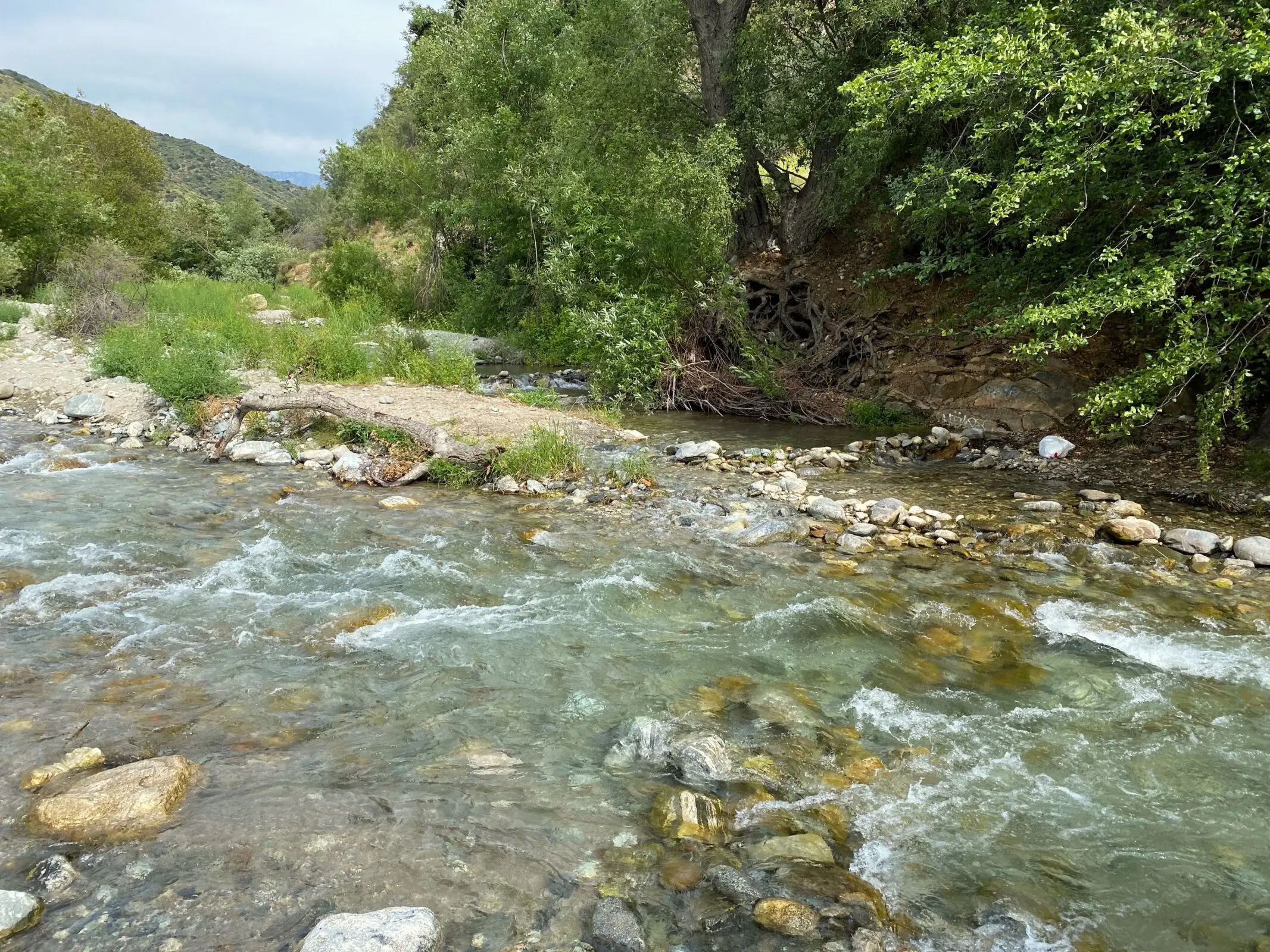
Highlights from the River Report Card
Heal the Bay graded 28 freshwater recreation areas in Los Angeles County within the L.A. River, San Gabriel River, and Malibu Creek Watersheds during summer 2020. 70% of the freshwater grades indicated a low risk of illness, 17% indicated a moderate risk of illness, and 13% indicated a high risk of illness.
L.A.’s Freshwater Fails List
Top 9 river recreation sites in Los Angeles County that are high-risk places to swim or boat.
1. Tujunga Wash at Hansen Dam – Upper L.A. River Watershed
2. L.A. River at Rattlesnake Park – L.A. River Watershed: Recreation Zones
3. San Gabriel River Below North and West Forks – San Gabriel River Watershed
4. L.A. River at Middle of Sepulveda Basin Recreation Zone – L.A. River Watershed: Recreation Zones
5-6. Bull Creek – Upper L.A. River Watershed
5-6. Lake Balboa Boat Ramp – Upper L.A. River Watershed
7. Lake Balboa Outlet – Upper L.A. River Watershed
8. L.A. River at Balboa Blvd. – L.A. River Watershed: Recreation Zones
9. Switzer Falls – Upper L.A. River Watershed
L.A.’s Freshwater Honor Roll List
Top 10 river recreation sites in Los Angeles County that are low-risk places to swim or boat.
1-8. San Gabriel River East Fork at Graveyard Canyon – San Gabriel River Watershed
1-8. L.A. River at Benedict St. (formerly Frogspot) – L.A. River Watershed: Recreation Zones
1-8. Gould Mesa – Upper L.A. River Watershed
1-8. Hansen Dam Lake – Upper L.A. River Watershed
1-8. San Gabriel River Lower North Fork – San Gabriel River Watershed
1-8. Sturtevant Falls – Upper L.A. River Watershed
1-8. San Gabriel River Upper North Fork – San Gabriel River Watershed
1-8. Big Tujunga Creek at Vogel Flats – Upper L.A. River Watershed
8-10. San Gabriel River Upper East Fork – Upper L.A. River Watershed
8-10. San Gabriel River Upper West Fork – San Gabriel River Watershed
Equity and Access
The COVID-19 pandemic, a record-setting wildfire season, and extreme heat during summer 2020 highlighted the dire need for equity in our waters, and exposed major systemic failures; open spaces, including beaches and rivers, are not equally accessible to all people. Low-income communities of color tend to be the most burdened communities, bearing the brunt of environmental pollution and limited access to open space.
“A day at the beach and the river shouldn’t make anyone sick,” said Dr. Shelley Luce, President and CEO of Heal the Bay. “With the closures, stress, and uncertainty of the pandemic, it is no surprise that people sought out our local waters in 2020. While we’re thrilled about the excellent water quality across California, our marine ecosystems are still threatened by climate change and other pollution sources. This is alarming as we expect people to increasingly seek out ocean shorelines and freshwater swimming holes to cool off as temperatures rise. Heal the Bay’s Beach Report Card and River Report Card give access to the latest water quality information and are a critical part of our science-based advocacy work in support of strong environmental and public health policies that improve the health and resilience of our ocean, our rivers, and our communities.”
Avoid shallow, enclosed beaches and freshwater areas with poor water circulation.
Swim at least 100 yards away from flowing storm drains, creeks, and piers.
Stay out of the water for at least 72-hours after a rain event.
Follow all local health and safety regulations, including all local pandemic-related regulations.
Check in with the lifeguard or ranger on duty for more information about the best places to swim.
About Heal the Bay
Heal the Bay is a 501(c)3 nonprofit organization founded in 1985. We use science, education, community action, and advocacy to fulfill our mission to protect coastal waters and watersheds in Southern California. Heal the Bay Aquarium, located at the Santa Monica Pier, welcomes 100,000 guests annually and hosts a variety of public programs and events that highlight local environmental issues and solutions. Learn more at healthebay.org and follow @healthebay on social media.
About Beach Report Card
Beach Report Card with NowCast, in partnership with World Surf League, is Heal the Bay’s flagship scientific water quality monitoring program that started in the 1990s. For thirty years, the Beach Report Card has influenced the improvement of water quality by increasing monitoring efforts and helping to enact strong environmental and public health policies. Learn more at beachreportcard.org and download the free app on iPhone and Android devices.
The Beach Report Card is made possible in part through generous support from SIMA Environmental Fund, Swain Barber Foundation, SONY Pictures Entertainment, and World Surf League.
About River Report Card
Currently, there is no statewide water quality monitoring mandate for rivers and streams in California, like we have for the ocean as a result of the Beach Report Card. Heal the Bay started the River Report Card in 2017 to push for new public health protections for freshwater areas in addition to serving the immediate need for increased public awareness about the risks at popular freshwater recreation areas in Los Angeles County. Learn more at healthebay.org/riverreportcard.
The River Report Card is made possible in part by generous support from Alice C. Tyler Perpetual Trust and Garfield Foundation.
Las playas de California tuvieron una excelente calidad de agua durante los meses de verano del 2020. De más de 500 playas en todo el estado, el 93% obtuvieron buenas calificaciones (A y B). Las precipitaciones del año pasado estuvieron drásticamente por debajo del promedio, lo que generalmente conlleva a una mejor calidad del agua debido a las cantidades reducidas de contaminantes que fluyen hacia el océano. Sin embargo, las calificaciones durante la temporada de lluvias fueron peores al promedio en este año, probablemente debido al hecho de que la mayoría de los datos durante la temporada de lluvias se recopilaron cuando se registraron las primeras lluvias (que son las más importantes) las cuales llevan más contaminación.
• La desembocadura del río Tijuana y la playa que se encuentra a menos de una milla al norte se encuentran en nuestra lista de las Peores Playas. Estas playas se ven afectadas por las aguas residuales que fluyen desde el río Tijuana y de la Planta de Tratamiento Punta Bandera. Las aguas residuales tienen su origen en la infraestructura del alcantarillado deteriorado e insuficiente en la ciudad de Tijuana.
• El condado de San Mateo continúa luchando con la calidad del agua, ya que tres playas en el área de Foster City se encuentran en la lista de las Peores Playas: Erckenbrack Park, Gull Park y Marlin Park. Erckenbrack Park apareció en la lista de las peores playas el año pasado junto con otras cinco playas del condado de San Mateo. Cuatro de esas peores playas del 2019 no fueron monitoreados en absoluto en 2020. Esto es alarmante ya que este tramo de costa ha experimentado altos niveles de contaminación fecal y es muy popular entre los bañistas que ahora no tienen información sobre la potencial contaminación.
• Capitola Beach en el Condado de Santa Cruz es la playa número tres en la lista de este año. El arroyo de Soquel Creek desemboca en el océano cerca de esta playa, descargando bacterias contaminantes de toda la cuenca. Esta playa ha sido un fastidio desde que se lanzó el Boletín de Calificaciones de Playas.
• La unica Peor Playa del condado de Los Ángeles es la palaya Mother’s Beach en Marina Del Rey, que no es ajena a la lista de las playas más contaminadas del estado. Esta playa está encerrada y experimenta poca acción de las olas, por lo que la contaminación bacteriana no se elimina facilmente.
• Clam Beach en el condado de Humboldt ha recibido el estatus de la Peor Playa en siete de los últimos 11 años. La calidad del agua en esta playa del norte de California se ve afectada negativamente por la escorrentía agrícola que fluye hacia el océano a través de los arroyos de Patrick Creek y Strawberry Creek.
• El Candlestick Point de San Francisco en Windsurfer Circle regresa a la lista después de una pausa de siete años. Candlestick Point se encuentra en la Bahía de San Francisco, y aunque no es un área encerrada, es probable que no experimente tanta circulación de agua como una playa de mar abierto.
• East Beach en Santa Bárbara está haciendo su primera aparición en la lista de las Peores Playas. La contaminación bacteriana del área de Santa Bárbara fluye en el océano hacia la playa de East Beach a través del arroyo de Mission Creek.
Las playas de Oregon no fueron monitoreadas con la frecuencia suficiente para recibir una calificación este verano, y no se monitorearon sus playas durante los meses de invierno. Solo cuatro condados de Oregon recibieron calificaciones durante la temporada de lluvias, que fueron mediocres y muy por debajo del promedio en temporada lluviosa del estado de 82% que recibieron calificaciones de A y B.
Las calificaciones durante la temporada seca de verano en el estado deWashington fueron excelentes y el 96% de las playas recibieron calificaciones de A y B. Las calificaciones en temporada lluviosa fueron excepcionales y por encima del promedio, con un 91% que recibieron calificaciones de A y B. Las playas del estado de Washington no fueron monitoreadas durante los meses de invierno, por lo que no se pudieron calcular las calificaciones durante la temporada seca de invierno.
El verano 2020 fue el primer año en que las playas de Tijuana, México se incluyeron en el Boletín de Calificaciones de Playas. Las playas de El Faro y El Vigía recibieron una B para las calificaciones durante la temporada seca de verano, mientras que Playas Blanca recibió una D. Las calificaciones durante la temporada seca de invierno mostraron un patrón similar donde El Faro y El Vigía recibieron una D, y Playas Blanca recibió una F. Las tres playas recibieron F para la temporada lluviosa. Este tramo de costa recibe a millones de visitantes cada año y se ve muy afectado por la contaminación de las aguas residuales durante todo el año, incluso durante la temporada seca. La fuente principal de contaminación es la planta de tratamiento Punta Bandera ubicada al sur de Tijuana, que regularmente libera aguas residuales no tratadas o parcialmente tratadas al océano.
El Boletín de Calificaciones de Playas se enfoca en la calidad del agua de las playas océanicas. Sin embargo, monitorear la calidad del agua en los sitios de agua dulce, como ríos, lagos y arroyos, y hacer que esa información esté disponible para el público también es importante para proteger la salud pública en sitios recreacionales. Heal the Bay creó el Boletín de Calificaciones de Ríos (River Report Card) para informar al público de la calidad del agua en nuestros ríos y arroyos. Heal the Bay recolecta muestras y analiza la calidad del agua en seis sitios recreacionales en el condado de Los Angeles, recopila datos de monitoreo de 22 stios adicionales del condado de Los Ángeles; y transforma los datos en grados codificados por colores de fácil comprensión. Antes de dirigirse a una área de recreación de agua dulce en el condado de Los Ángeles, consulte nuestro River Report Card en , que se actualiza regularmente durante los meses de verano.
Heal the Bay también patrocina el Proyecto de Ley 1066 de la Asamblea (Bloom) en California, que es el primer paso para garantizar que los sitios de recreación de agua dulce en el estado sean monitoreados para detectar contaminación fecal y que se informe a la comunidad.


")